| Mount Shaw Trail Maps |
Top |
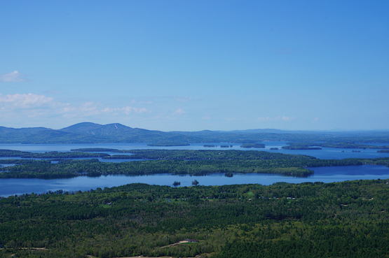
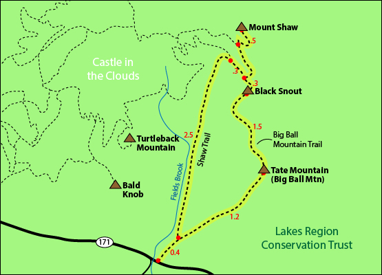
The map below shows how to get to the summit of Mount Shaw as well as Black Snout and Tate Mountain (Big Ball Mountain) via the Shaw Trail.
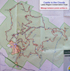
(NOTE: Most of the trails in the route below are NOT on the Castle in the Clouds Estate trail map, so if you are trying to get the hiker achievement patch, click here to see a trail map of appropriate trails.)
Starting on the Shaw Trail, hike for 0.4 miles until you come to a fork with the Italian Trail. (You can go either way since this is a loop hike, but the rest of these directions will go right, counter-clock-wise).
Go right at the fork onto the Italian Trail. Hike for 1.2 miles until you reach the summit of Tate Mountain (also known as Big Ball Mountain). After enjoying the summit, continue along the blue-blazed trail, which not turns into the Big Ball Mountain Trail, for 1.5 miles until you reach the summit of Black Snout. From the Black Snout outlook, follow the Black Snout Spur Trail for 0.3 miles where it will lead straight/right into High Ridge Trail. After 0.5 miles on the High Ridge Trail, you will be at the summit of Mount Shaw.
To get back down to the parking lot, retrace your steps on the High Ridge Trail for 0.5 miles going straight/left onto the Black Snout Trail (where High Ridge Trail continues to the right). Follow Black Snout Trail for 0.5 miles, (skipping the spur trail on the left after 0.3 miles and then turning left onto the Shaw Trail while Black Snout Trail continues straight). Hike down the Shaw Trail for 2.5 miles until you reach the road.
Click to download PDF Trail Map of Mount Shaw.
|