|
|
| Mount Eisenhower |
| |
| On this page: Information | Trail maps | View Photos | Driving Directions |
| |
| Mount Eisenhower Information |
Elevation: 4,780 feet (1,456.9 meters)
Prominence:  350 feet (106.7 meters) 350 feet (106.7 meters)
Location: Carroll, NH (Coös County, New Hampshire, USA)
Range: Presidential Range
Coordinates: 44°14.44′North 71°21.02′West
Rating: Moderate/Difficult
Features: Alpine Zone , Brooks, Cascades, Crawford Cliff, Peak Bagging , Mizpah Spring Hut, 360 Degree Views
Distance of highlighted hike below: 10.4 miles
|
 |
Mount Pierce (Formerly named Mount Pleasant) is a 4,780 foot mountain in the Presidential Range in Carroll, New Hampshire, Coös County in the White Mountains. It's summit offers 360 degree views of the New Hampshire mountains including Mount Washington. It was named after President Dwight D.Eisenhower. The two most common routes to Mount Eisenhower's summit are the Crawford Path and Edmands Path, both beginning on Mount Clinton Road (in different parking lots).
Many people choose to hike Mount Pierce and Mount Eisenhower on the same hike by making a loop, this is known as Peak-Bagging (also mountain bagging, hill bagging, summit to summit). It is a great way to cross multiple mountains off your list in one day, and not to mention have multiple views!
. |
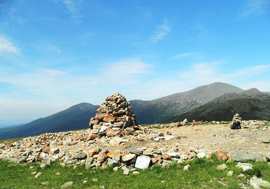
Cairn at the top of Mount Eisenhower on June 19, 2010, overlooking Mount Washington. |
| |
| Mount Eisenhower Trail Maps - Directions from the parking lot to the summit |
Top |
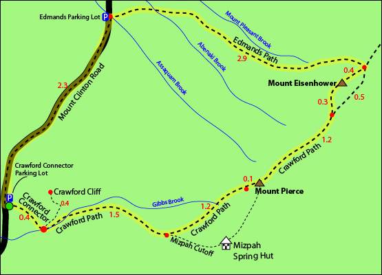
The map below shows how to get to the summit of Mount Eisenhower, as well as Mount Pierce.
This is a loop hike (see map below) and there are 2 parking lots you can park at: the Edmands parking lot or the Crawford Connector parking lot. (both on Mount Clinton Road) The directions below are based on parking in the Crawford Connector parking lot, hiking up to Mount Pierce then over to Mount Eisenhower, and back to the same parking lot.
Begin on the Crawford Connector Trail for 0.4 miles.You will come to a foot bridge over Gibbs Brook, where there are beautiful cascades to look at. Just after you cross the bridge, follow the signs vearing left/straight to begin the Crawford Path Trail up to the summit of Mount Pierce (going right will bring you to Route 302).
After 0.2 miles on the Crawford Path, you will see a sign on the left for Gibbs Fall. Follow the path for about 40 yards to see the amazing Gibbs Falls. Retrace your steps back the 40 yards to the Crawford Path to continue your hike up to the summit. After 1.3 miles, you will arrive at a junction where you will want to stay left (right will bring you to the Mizpah Cutoff). Continue on the Crawford Path for an additional 1.2 miles where you will reach a junction with the Webster Cliff Trail. Turn right on the Webster Cliff Trail, which is part of the Appalachian Trail. The summit of Mount Pierce is only 0.1 miles up. Descend 0.1 miles down the Webster Cliff Trail to get back onto the Crawford Path Trail by turning right. Follow for 1.2 miles until it meets up with the Eisenhower Loop. Bear left to follow the loop for 0.4 miles up to the summit of Mount Eisenhower. Here you will see its 360 degree fantastic views! To get back to your car from here, you can either retrace your steps back to Mount Pierce, then back down to the parking lot, or you can hike down the Edmand's Path. To take the Edmand's Path down, first continue along the Mount Eisenhower Loop Trail, descending Mount Eisenhower on the opposite side you climbed up. You will meet up with the Edmand's Path Trail in 0.4 miles. Turn left and follow for 2.9 miles where you will land at a parking lot (Edmands parking). You will need to walk on Mount Clinton Road by turning left for 2.3 miles until you reach the Crawford Connector parking lot, where you began your hike. (It is a quiet scenic road walk. Not alot of traffic.)
Click to download PDF Trail Map of Mount Eisenhower
|
| |
| Mount Eisenhower Photos |
Top |
|
|
| Mount Eisenhower Driving Directions |
Top |
Both parking lots for this hike are located on Mount Clinton Road off Route 302 in Carroll, New Hampshire.
To the Crawford Connector parking lot
From the junction of Route 3 and Route 302 in Twin Mountain, New Hampshire, follow Route 302 East bound for 8.0 miles. Turn left onto Mount Clinton Road. If you are traveling from the East, Mount Clinton Road will be on the right hand side of the road .20 miles past the AMC Highland Center (or roughly 3.0 miles West of the Willey House Historical Site.) Take your first left on Mount Clinton Road into a parking lot. The Crawford Connector Trail begins at the far end of the parking lot (to the right of the toilets).
To the Edmands Path parking lot
From the Crawford Connector parking lot (directions above) continue down Mount Clinton Road for 2.3 miles until you reach a parking lot on the right. |
|
On this page: Information | Trail maps | View Photos | Driving Directions | Top
.
|
|
|