| View all NH 4,000 Footers |
| Mount Adams |
| Mount Bond |
| Bondcliff |
| Mount Bond, West Peak |
| Mount Cabot |
| Cannon Mountain |
| Mount Carrigain |
| Carter Dome |
| Carter, Middle |
| Carter, South |
| Mount Eisenhower |
| Mount Field |
| Mount Flume |
| Mount Galehead |
| Mount Garfield |
| Mount Hale |
| Mount Hancock |
| Mount Hancock, South Peak |
| Mount Isolation |
| Mount Jackson |
| Mount Jefferson |
| Mount Kinsman, North Peak |
| Mount Kinsman, South Peak |
| Mount Lafayette |
| Mount Liberty |
| Mount Lincoln |
| Mount Madison |
| Mount Monroe |
| Mount Moosilauke |
| Mount Moriah |
| Mount Osceola |
| Mount Osceola, East Peak |
| Owl's Head |
| Mount Passaconway |
| Mount Pierce |
| Mount Tecumseh |
| Mount Tom |
| Mount Tripyramid, Middle Peak |
| Mount Tripyramid, North Peak |
| Mount Twin, North Peak |
| Mount Twin, South Peak |
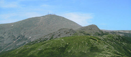
| Mount Washington |
| Mount Waumbek |
| Mount Whiteface |
| Mount Wildcat, A Peak |
| Mount Wildcat, D Peak |
| Mount Willey |
| Zealand Mountain |
| NH Mountain Ranges/ Areas ↓ |
| View all NH Mountain Ranges |
| Baldface-Royce Range |
| Carter-Moriah Range |
| Dartmouth Range |
| Franconia Range |
| Kinsman Range |
| Mahoosuc Range |
| Northern Ranges |
| Ossipee Mountains |
| Pemigewasset Wilderness |
| Pilot Range |
| Pliny Range |
| Presidential Range |
| Sandwich Range |
| Twin Range |
| Wapack Range |
| Willey Range |
|
|
Hike Mount Washington |
| |
| On this page: Information | Trail maps | View Photos | Driving Directions | Cog Railway | Auto Road |
| |
| Mount Washington Information |
Elevation: 6,288 feet (1,917 meters)
Prominence:  6,138 feet (1,871 meters) 6,138 feet (1,871 meters)
Location: Pinkham's Grant, NH (Coös County, New Hampshire)
Range: Presidential Range
Coordinates: 44°16'13" North 71°18'12" West
Rating: Difficult
Features: Waterfalls, Cascades, Brooks, Lakes of the Clouds Hut + Lakes, 360 Degree Views, Peak Bagging
Distance of highlighted hike below: 9.5 miles (You can add in Mount Monroe by adding 0.8 miles to the hike)
|
 |
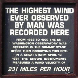
Mount Washington is a 6,288 foot mountain in the Presidential Range of the White Mountains. It is the highest mountain (in both elevation and prominence) in New Hampshire, as well as New England. The worlds highest wind gusts were recorded at the summit on April 12, 1934 at a whopping 231 miles per hour! The main building was built to withstand wind gusts of up to 300 mph, while the other structures on the summit are chained down right into the mountain. The weather at the summit and along trails leading up to it can change in an instant, so if you plan on being on the summit, via hiking, riding the cog train or driving, dress appropriately and bring extra clothes.
 |
Mt. Washington Weather Averages + Records |
| Average high temperature |
33.9° f |
| Average low temperature |
20.4° f |
| Record high temperature |
72° f |
| Record low temperature |
-50° f |
| Average precipitation |
101 in |
| Average precipitation days/year |
215 |
| Average snowfall |
311 in |
| Average snowfall days/year |
125 |
| |
| For peak-baggers: |
Mount Clay is roughly 1.8 miles from the summit of Mount Washington
Mount Monroe is 1.9 miles from the summit of Mount Washington
|
|
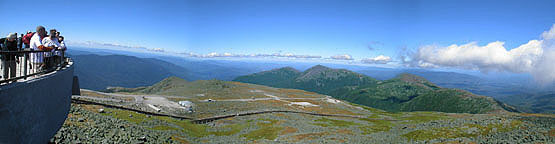
Observation Deck on Mount Washington. September 11, 2010.
|
| |
| Mount Washington Trail Maps - Directions from the parking lot to the summit |
Top |
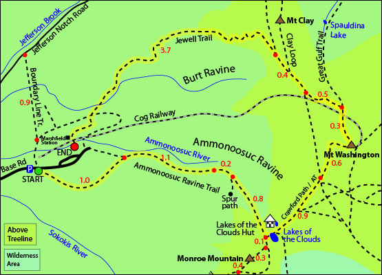
The map below shows how to get to the summit of Mount Washington, as well as the Lakes of the Clouds Hut and Lakes via the Ammonoosuc Ravine Trail with the Jewell Trail as a loop hike.
Begin at the Marshfield Station Parking Lot off Base Road in Pinkham's Grant, New Hampshire on the Ammonoosuc Raving Trail. Follow for 1.0 miles until you reach a junction. Left will take you back to the parking lot, and right / straight will continue up the trail. Continue straight / right up the Ammonoosuc Ravine Trail for 2.1 miles until you reach the Lakes of the Clouds Hut and lakes. From the hut, take the Crawford Trail towards the left for 1.5 miles until you reach the summit of Mount Washington. You will come to a junction 0.9 miles after the hut with the West Side Trail and Davis Path, but stay on the Crawford Path to reach the summit.
To descend down the Jewell Trail, begin on the Great Gulf Trail from the summit. Hike roughly 0.3 miles until you reach the Jewell Trail junction. Continue down for 0.5 miles until you reach a junction with the West Side Trail. Continue straight / right for 0.4 miles until you reach another junction with the Gulfside Trail. Stay left to continue down the Jewell Trail for 3.7 miles until you reach the parking lot.
Click to download PDF Trail Map of Mount Washington
|
| |
| |
| Mount Washington Photos |
Top |
|
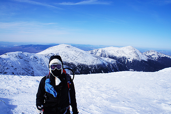
Hiker with Mount Washington in the background on March 7, 2012.
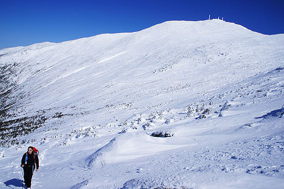
Hiking down the Jewell Trail on March 7, 2012.
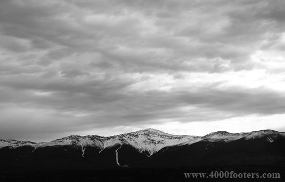
Photo taken from the Omni Mount Washington Hotel in April.
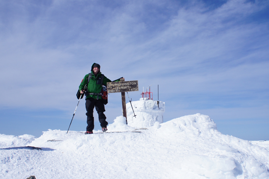
Mount Washington Winter summit photo.
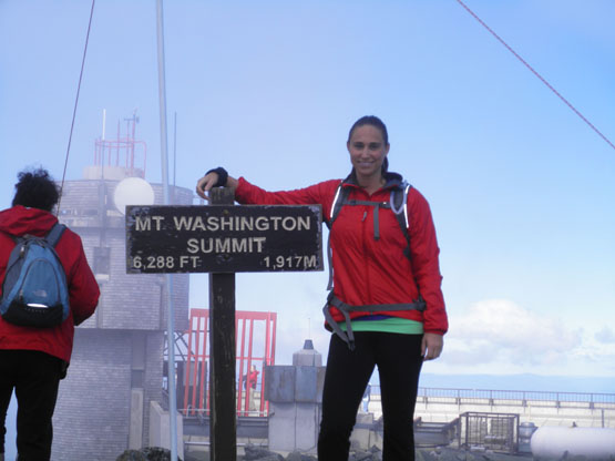
Mount Washington Fall summit photo. Taken on September 11, 2010.
|
| Mount Washington Driving Directions |
Top |
The parking lot for this hike is located at the Marshfield Station parking area in Pinkham's Grant, New Hampshire (where the Cog Railway begins).
If you are traveling North on I-93
Take I-93 North or I-293 North through Franconia Notch Parkway to Exit 35, Route 3N. Take Route 3N for approximately 10-12 miles to Twin Mountain, NH. Follow Route 302E for five miles to Bretton Woods, NH. Turn left at Fabyan's Station Restaurant onto the Base Road. Continue six miles on Base Road to the Cog Base Station / Marshfield Station parking lot.
If you are traveling South on I-93
Take Route 302W to Bretton Woods, NH. Turn right at Fabyan's Station Restaurant onto the Base Road. Continue six miles on Base Road to the Cog Base Station / Marshfield Station parking lot.
Mount Washington From Mount Eisenhower. June 19, 2010.
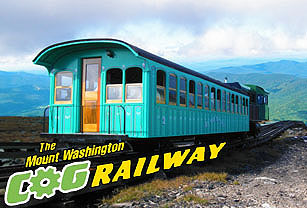
| Mount Washington Cog Railway Information |
Top |
The Cog Railway has provided tourists with a train journey to the summit of Mount Washington since 1869. It was the world's first mountain-climbing Cog Railway Train and uses a Marsh rack system. This slow train allows riders to view the incredible views of Mount Washington and its surrounding Mountains along the steepest railroad tracks in North America.
|
|
Mount Washington cog railway
Base Road
Six miles off Route 302
Bretton Woods, New Hampshire 03575
Phone: 800-922-8825
Local phone: 603-278-5404 |
Directions to the Cog Railway
From Boston, MA and Manchester, NH
• Take I-93 North or I-293 North through Franconia Notch Parkway to Exit 35, Route 3N.
• Take Route 3N for roughly 10-12 miles to Twin Mountain, NH.
• Follow Route 302E for five miles to Bretton Woods, NH.
• Turn left at Fabyan's Station Restaurant onto the Base Road.
• Continue six miles on Base Road to the Cog Base Station.
From Portland, ME
• Take Route 302W to Bretton Woods, NH.
• Turn right at Fabyan's Station Restaurant onto the Base Road.
• Continue six miles on Base Road to the Cog Base Station.
From New York, NY and Hartford, CT
• Take I-95 North to I-91 North.
• Take I-91 North to I-93 South, Follow I-93 to Exit 40.
• Follow Route 302E roughly 15 miles to Bretton Woods, NH.
• Turn left at Fabyan's Station Restaurant onto the Base Road.
• Continue six miles on Base Road to the Cog Base Station.
From Montreal, Québec
• Take Auto Route 10E to Auto Route 55S.
• Take Auto Route to I-91 South.
• Take I-91 South to I-93 South, Follow I-93 to Exit 40.
• Follow Route 302E roughly 15 miles to Bretton Woods, NH.
• Turn left at Fabyan's Station Restaurant onto the Base Road.
• Continue six miles on Base Road to the Cog Base Station.
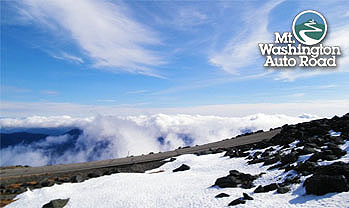
| Mount Washington Auto Road Information |
Top |
Drive into the clouds on New England's tallest mountain with your own car up Mount Washington!
|
|
Mount. Washington Auto Road
Route 16, Pinkham Notch
P.O. Box 278
Gorham, NH 03581
Phone: 603-466-3988
Fax:
603-466 3328 |
|
|
On this page: Information | Trail maps | View Photos | Driving Directions | Cog Railway | Auto Road
|
|
|
|
|
|
|
|
|
|
|
|
|
|
|
|
|
|
| |
| |
|
| New Hampshire 4,000 Footers |
Vermont + Maine 4,000 Footers |
Other Hiking Lists / Patches |
New England Mountain Ranges |
Stay Involved in New England |
New Hampshire
Mount Adams
Mount Bond
Bondcliff
Mount Bond, West Peak
Mount Cabot
Cannon Mountain
Mount Carrigain
Carter Dome
Carter, Middle
Carter, South
Mount Eisenhower
Mount Field
Mount Flume
Mount Galehead
Mount Garfield
Mount Hale
Mount Hancock
Mount Hancock, South Peak
Mount Isolation
Mount Jackson
Mount Jefferson
Mount Kinsman, North Peak
Mount Kinsman, South Peak
Mount Lafayette
Mount Liberty
Mount Lincoln
Mount Madison
Mount Monroe
Mount Moosilauke
Mount Moriah
Mount Osceola
Mount Osceola, East Peak
Owl's Head
Mount Passaconway
Mount Pierce
Mount Tecumseh
Mount Tom
Mount Tripyramid, Middle Peak
Mount Tripyramid, North Peak
Mount Twin, North Peak
Mount Twin, South Peak
Mount Washington
Mount Waumbek
Mount Whiteface
Mount Wildcat, A Peak
Mount Wildcat, D Peak
Mount Willey
Zealand Mountain |
Vermont
Mount Abraham
Camel's Hump
Mount Ellen
Killington Peak
Mount Mansfield
Maine
Mount Abraham
Mount Bigelow, Avery Peak
Mount Bigelow, West Peak
Crocker Mountain
Crocker Mountain, South
Mount Katahdin, Baxter Peak
Mount Katahdin, Hamlin Peak
North Brother Mountain
Old Speck Mountain
Mount Redington
Saddleback Mountain
Saddleback Mountain, The Horn
Spaulding Mountain
Sugarloaf Mountain |
NH 4,000 footers
NH 4,000 footers in Winter
New England 4,000 footers
NE 4,000 footers in Winter
NH Hundred Highest
New England Fifty Finest
52 With a view
Trailwrights 72 summit club
New England Hundred highest
NE Hundred highest in Winter
Northeast 111
48x12 "The Grid"
Red Lining
Belknap Range
LRCT / Castle in the Clouds
NH Fire Tower Quest
Hike by - Alphabetically
Hike by - Elevation
Hike by - Prominence
Hike by - Mountain Range |
Ranges in New Hampshire
View all NH mountain ranges
Baldface-Royce Range
Carter-Moriah Range
Dartmouth Range
Franconia Range
Kinsman Range
Mahoosuc
Range
Ossipee Mountains
Northern Ranges
Pemigewasset Wilderness
Pilot Range
Pliny Range
Presidential Range
Sandwich Range
Twin Range
Wapack Range
Western White Mountains
Willey Range
Ranges in Maine
View all ME mountain ranges
Baxter State Park
High Peaks
Bigelow Range
Eastern White Mountains
Ranges in Vermont
Green Mountains
Other VT mountain ranges |
NH Waterfalls
NH AMC Huts
Hiker's store |
New England 4,000 Footers | NH 4,000 Footers | VT 4,000 Footers | ME 4,000 Footers | Hiking Lists & Patches | Hiker's Store | Contact by email
© www.4000footers.com 2015. All rights reserved. We are not affiliated with the AMC or the AMC Four Thousand Footer Club |
|
|


