|
|
| Mount Field |
| |
| On this page: Information | Trail maps | View Photos | Driving Directions |
| |
Elevation: 4,331 feet (1,320 meters)
Prominence:  1,706 feet (520 meters) 1,706 feet (520 meters)
Location: Whitefield, NH (Grafton County, New Hampshire)
Range: Willey Range
Coordinates: 44°11'77" North 71°26'00" West
Rating: Easy/Moderate
Features: Brooks, Ripley Falls, Limited summit views Peak Bagging 
Distance of highlighted hike below: 11.2 miles
|
 |
Mount Field is a 4,331 foot mountain in the Willeyl Range of the White Mountains. It is the highest peak in the Willey Range.The mountain is named after Darby Field, who made the first known ascent up the tallest mountain in New England, Mount Washington, in 1642. This mountain is an easy/moderate hike and can be peak bagged along with Mount Tom and Mount Willey.
|
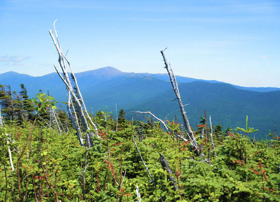
Photo taken from the summit of Mount Field on August 8, 2010. |
| |
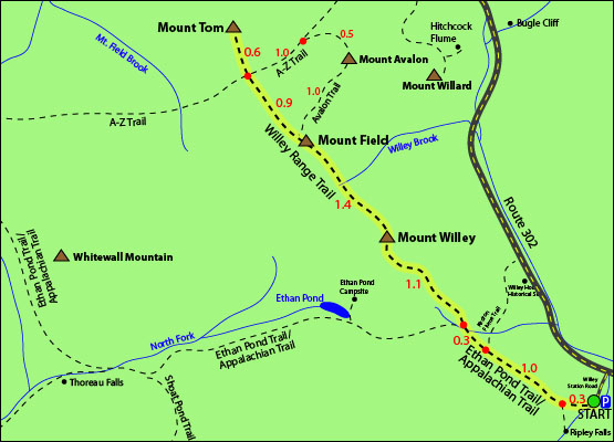
| Mount Field Trail Maps - Directions from the parking lot to the summit |
Top |
The map below shows how to get to the summit of Mount Field, as well as Mount Tom and Mount Willey.
The parking lot for this hike is on the end of Willey Station Road off Route 302 in Whitefield, New Hampshire. Your hike begins on the Ethan Pond Trail, which is also part of the Appalachian Trail. Follow this trail for 0.3 miles (you will cross railroad tracks close to the parking lot). Continue straight up for 2.7 miles until you reach the summit of Mount Willey. Continue over the summit of Mount Willey via the Willey Range Trail, and hike for 1.4 miles until you reach the summit of Mount Field. To continue your hike up to the summit of Mount Tom, continue along the Willey Range Trail for 0.9 miles until you come to an intersection with the A-Z Trail. You will see a sign for Mount Tom Spur ahead. Head up that trail and you will reach Mount Tom's summit in 0.6 miles. To get back to the parking lot, retrace your steps back down the Willey Range Trail for 4 miles, and the remaining 1.6 miles on the Ethan Pond Trail/Appalachian Trail.
For a spectacular waterfall view, hike down the Ripley Falls Trail, 0.3 miles from the parking lot. The trail is 0.4 miles long and leads to Ripley Falls, a 100 foot avalanche brook.
Click to download PDF Trail Map of Mount Jefferson
|
| |
|
|
| Mount Field Driving Directions |
Top |
The parking lot for this hike is located on Willey Station Road off of Route 302 in Whitefield, New Hampshire. Go to the end of the road, where there is a small parking lot. (You are allowed to park along Willey Station Road if the parking area is full.) |
|
On this page: Information | Trail maps | View Photos | Driving Directions | Top
.
|
|
|