| New Hampshire 4,000 Footers |
| Mount Adams |
| Mount Bond |
| Bondcliff |
| Mount Bond, West Peak |
| Mount Cabot |
| Cannon Mountain |
| Mount Carrigain |
| Carter Dome |
| Carter, Middle |
| Carter, South |
| Mount Eisenhower |
| Mount Field |
| Mount Flume |
| Mount Galehead |
| Mount Garfield |
| Mount Hale |
| Mount Hancock |
| Mount Hancock, South Peak |
| Mount Isolation |
| Mount Jackson |
| Mount Jefferson |
| Mount Kinsman, North Peak |
| Mount Kinsman, South Peak |
| Mount Lafayette |
| Mount Liberty |
| Mount Lincoln |
| Mount Madison |
| Mount Monroe |
| Mount Moosilauke |
| Mount Moriah |
| Mount Osceola |
| Mount Osceola, East Peak |
| Owl's Head |
| Mount Passaconway |
| Mount Pierce |
| Mount Tecumseh |
| Mount Tom |
| Mount Tripyramid, Middle Peak |
| Mount Tripyramid, North Peak |
| Mount Twin, North Peak |
| Mount Twin, South Peak |
| Mount Washington |
| Mount Waumbek |
| Mount Whiteface |
| Mount Wildcat |
| Mount Wildcat, D Peak |
| Mount Willey |
| Zealand Mountain |
|
| Mount Tom |
| |
| On this page: Information | Trail maps | View Photos | Driving Directions |
| |
Elevation: 4,052 feet (1,235 meters)
Prominence:  331 feet (101 meters) 331 feet (101 meters)
Location: Whitefield, NH (Grafton County, New Hampshire)
Range: Willey Range
Coordinates: 44°12.64′North 71°26.77′West
Rating: Easy/Moderate
Features: Brooks, Ripley Falls, Limited summit views Peak Bagging
Distance of highlighted hike below: 11.2 miles
|
 |
Mount Tom is a 4,052 foot mountain in the Willey Range in Whitefield, New Hampshire, Grafton County in the White Mountains. The mountain is named after Thomas Crawford, whose family ran the Crawford House.
The shortest trail up to the summit of Mount Tom is the Willey Range Trail. This mountain is a great peak-bagger to do along with Mount Field and Mount Willey, (both 4,000 footers) as they are all roughly 1.5 miles apart. Mount Avalon is also a short distance (1 mile) away, but its elevation is 3,399 feet, so it is not included on the New Hampshire 4,000 footers list. Mount Willey is popular for hand-feeding the birds at the summit. Many people simply hold out their hand with a piece of food lodged inbetween their fingers, and wait for a bird to land for a snack.
|
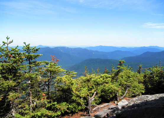
Photo taken from standing on the carin at the summit of Mount Hale on August 8, 2010. |
| |
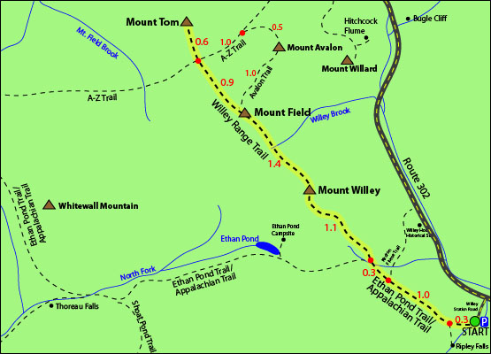
| Mount Tom Trail Maps - Directions from the parking lot to the summit |
The map below shows how to get to the summit of Mount Tom, as well as Mount Field and Mount Willey.
The parking lot for this hike is on the end of Willey Station Road off Route 302 in Whitefield, New Hampshire. Your hike begins on the Ethan Pond Trail, which is also part of the Appalachian Trail. Follow this trail for 0.3 miles (you will cross railroad tracks close to the parking lot). Continue straight up for 2.7 miles until you reach the summit of Mount Willey. Continue over the summit of Mount Willey via the Willey Range Trail, and hike for 1.4 miles until you reach the summit of Mount Field. To continue your hike up to the summit of Mount Tom, continue along the Willey Range Trail for 0.9 miles until you come to an intersection with the A-Z Trail. You will see a sign for Mount Tom Spur ahead. Head up that trail and you will reach Mount Tom's summit in 0.6 miles. To get back to the parking lot, retrace your steps back down the Willey Range Trail for 4 miles, and the remaining 1.6 miles on the Ethan Pond Trail/Appalachian Trail.
For a spectacular waterfall view, hike down the Ripley Falls Trail, 0.3 miles from the parking lot. The trail is 0.4 miles long and leads to Ripley Falls, a 100 foot avalanche brook.
Click to download PDF Trail Map of Mount Tom
|
| |
|
| |
| Mount Tom Driving Directions |
The parking lot for this hike is located on Willey Station Road off of Route 302 in Whitefield, New Hampshire. Go to the end of the road, where there is a small parking lot. (You are allowed to park along Willey Station Road if the parking area is full.) |
| |
| On this page: Information | Trail maps | View Photos | Driving Directions |
|
|