| New Hampshire 4,000 Footers |
| Mount Adams |
| Mount Bond |
| Bondcliff |
| Mount Bond, West Peak |
| Mount Cabot |
| Cannon Mountain |
| Mount Carrigain |
| Carter Dome |
| Carter, Middle |
| Carter, South |
| Mount Eisenhower |
| Mount Field |
| Mount Flume |
| Mount Galehead |
| Mount Garfield |
| Mount Hale |
| Mount Hancock |
| Mount Hancock, South Peak |
| Mount Isolation |
| Mount Jackson |
| Mount Jefferson |
| Mount Kinsman, North Peak |
| Mount Kinsman, South Peak |
| Mount Lafayette |
| Mount Liberty |
| Mount Lincoln |
| Mount Madison |
| Mount Monroe |
| Mount Moosilauke |
| Mount Moriah |
| Mount Osceola |
| Mount Osceola, East Peak |
| Owl's Head |
| Mount Passaconway |
| Mount Pierce |
| Mount Tecumseh |
| Mount Tom |
| Mount Tripyramid, Middle Peak |
| Mount Tripyramid, North Peak |
| Mount Twin, North Peak |
| Mount Twin, South Peak |
| Mount Washington |
| Mount Waumbek |
| Mount Whiteface |
| Mount Wildcat |
| Mount Wildcat, D Peak |
| Mount Willey |
| Zealand Mountain |
|
| Mount Hale |
| |
| On this page: Information | Trail maps | View Photos | Driving Directions |
| |
Elevation: 4,055 feet (1,236 meters)
Prominence:  614 feet (187 meters) 614 feet (187 meters)
Location: Bethlehem, NH (Grafton County, New Hampshire)
Range: Twin Range
Coordinates: 44°13.30′North 71°30.73′West
Rating: Easy
Features: Brooks, Cascades, Limited summit views
Distance of highlighted hike below: 4.6 miles
|
 |
Mount Hale is a 4,055 foot mountain in the Twin Range in Bethlehem, New Hampshire, Grafton County in the White Mountains. The mountain is named after Reverend Edward Everett Hale.
The shortest trail up to the summit of Mount Hale is the Hale Brook Trail. Mount Hale is considered one of the easiest hikes out of all the 4,000 footers. It is a short 2.2 mile hike to the summit, and a relatively straight path. This is not one of the more popular 4,000 footers because of it's very limited summit views. The summit is basically an open circle field with a big carin (rock pile, usually a summit indicator) in the center, surrounded by trees. There is evidence of a fire tower that used to be there. Your best bet to see any views is to climb up the carin and look out, but even then, the views are limited.
. |
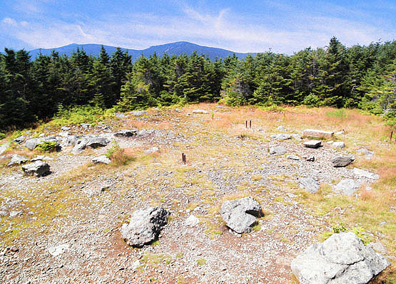
Photo taken from standing on the carin at the summit of Mount Hale on August 8, 2010. |
| |
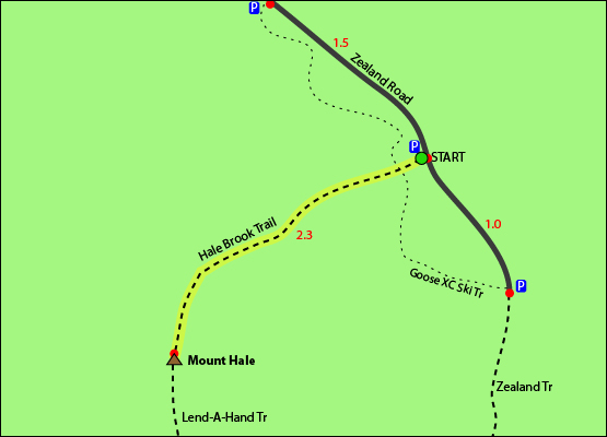
| Mount Hale Trail Maps - Directions from the parking lot to the summit |
The map below shows how to get to the summit of Mount Hale.
This is an easy to follow hike. You begin on the Hale Brook Trail and follow for 2.3 miles until you reach the summit of Mount Hale. It is a fairly straight trail with no intersections or forks. To break the hike up into sections, 0.8 miles from the parking lot, you will cross the brook, and again at 0.5 miles, and again at 0.4 miles, leaving 0.6 miles left to hike to the summit. To get back to the parking lot, retrace your steps and descend the Hale Brook Trail for 2.3 miles.
Click to download PDF Trail Map of Mount Hale
|
| |
|
| |
| Mount Hale Driving Directions |
The parking lot for this hike is located on Zealand Road in Bethlehem, New Hampshire. It is roughly 2.5 miles up Zealand Road on the right hand side. You will pass several Sugarloaf Mountain campground sites before reaching the parking lot. The trail begins slighty to the right (when standing on the road looking at the parking lot) behind the Brown wooden information station. |
| |
| On this page: Information | Trail maps | View Photos | Driving Directions |
|
|