| New Hampshire 4,000 Footers |
| Mount Adams |
| Mount Bond |
| Bondcliff |
| Mount Bond, West Peak |
| Mount Cabot |
| Cannon Mountain |
| Mount Carrigain |
| Carter Dome |
| Carter, Middle |
| Carter, South |
| Mount Eisenhower |
| Mount Field |
| Mount Flume |
| Mount Galehead |
| Mount Garfield |
| Mount Hale |
| Mount Hancock |
| Mount Hancock, South Peak |
| Mount Isolation |
| Mount Jackson |
| Mount Jefferson |
| Mount Kinsman, North Peak |
| Mount Kinsman, South Peak |
| Mount Lafayette |
| Mount Liberty |
| Mount Lincoln |
| Mount Madison |
| Mount Monroe |
| Mount Moosilauke |
| Mount Moriah |
| Mount Osceola |
| Mount Osceola, East Peak |
| Owl's Head |
| Mount Passaconway |
| Mount Pierce |
| Mount Tecumseh |
| Mount Tom |
| Mount Tripyramid, Middle Peak |
| Mount Tripyramid, North Peak |
| Mount Twin, North Peak |
| Mount Twin, South Peak |
| Mount Washington |
| Mount Waumbek |
| Mount Whiteface |
| Mount Wildcat |
| Mount Wildcat, D Peak |
| Mount Willey |
| Zealand Mountain |
|
| Mount Osceola |
| |
| On this page: Information | Trail maps | View Photos | Driving Directions |
| |
| Mount Osceola Information |
Elevation: 4,340 feet (1,315.2 meters)
Prominence:  2,080 feet (634 meters) 2,080 feet (634 meters)
Location: Lincoln, NH (Grafton County, New Hampshire)
Range: Sandwich Range
Coordinates: 44°05.81′North 32°08.21′West
Rating: Easy/Moderate
Features: Brooks, Cascades, 180 Degree Views,
Peak Bagging
Distance of highlighted hikes below: 6.4 and 7.6 miles
|
 |
Mount Osceola is a 4,340 foot mountain in the Sandwich Range in Lincoln, New Hampshire, Grafton County in the White Mountains. The mountain is named after a seminole (a Native American tribe). There used to be a fire tower atop Mount Osceola, but was removed in the 1970s, but even without the tower, the views are incredible. Mount Osceola overlooks most of the White Mountains, including Mount Washington and the town of Waterville Valley, New Hampshire. Its summit is bare rock, and only has trees in the way of the view for roughly 180 degrees, leaving another 180 degrees exposed to the views.
The easiest and most common trail used to reach Mount Osceola's summit is the Greeley Pond Trail begginging on the Kancamagus Highway (Route 112) in Lincoln, New Hampshire. Shortly after a mile on the trail, there is a fork at the Mount Osceola Trail that goes up to the summit of Mount Osceola, after crossing over East Osceola Mountain. Great peak bagging mountains. Another option to get to the summit of Mount Osceola without East Osceola Mountain is the Mount Osceola Trail via Tripoli Road in Livermore, New Hampshire (just north of Waterville Valley).
. |
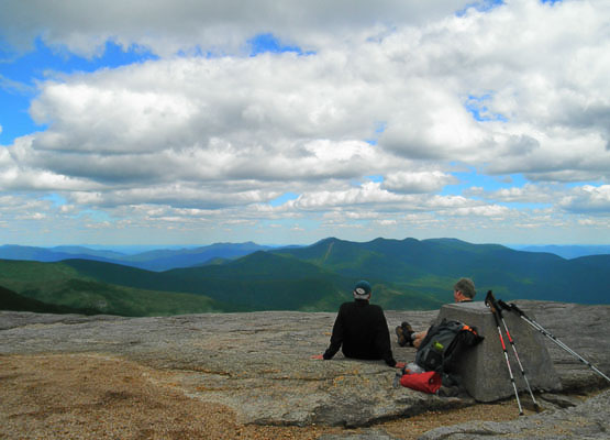
Photo taken from standing on the carin at the summit of Mount Hale on August 8, 2010. |
| |
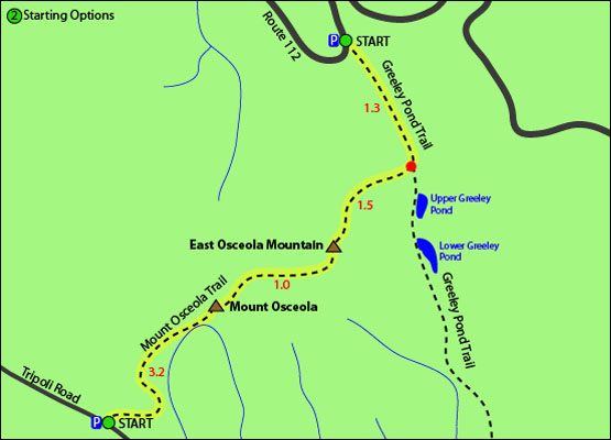
| Mount Osceola Trail Maps - Directions from the parking lot to the summit |
The map below shows how to get to the summit of Mount Osceola as well as East Osceola Mountain.
There are 2 different routes you can choose to hike Mount Osceola, one includes peak baggging it along with East Osceola Mountain.
To hike both mountains
Begin on the Greeley Pond Trail via the Kancamagus Highway (Route 112) in Lincoln, New Hampshire and hike for 1.3 miles until you come to a fork in the trail with Mount Osceola Trail, where you will bear right to switch trails. Follow this trail up for 1.5 miles to the summit of East Osceola Mountain. From there, continue over the summit on Mount Osceola Trail for 1.0 miles where you will find yourself on the summit of Mount Osceola. To get back to the parking lot, retrace your steps the same way you came up.
To hike just Mount Osceola
Begin
on Mount Osceola Trail via Tripoli Road in Livermore, New Hampshire. Hike for 3.2 miles until you reach the summit of Mount Osceola. To get back to the parking lot, retrace your steps down Mount Osceola Trail for 3.2 miles.
Click to download PDF Trail Map of Mount Osceola
|
| |
| Mount Osceola View Photos |
|
| |
| Mount Osceola Driving Directions |
There are 2 different parking lots you can park at for these hikes (refer to map above).
The parking lot to hike both Osceola mountains (via the shorter hike) is located on the Kancamagus Highway (Route 112) in Lincoln, New Hampshire.
From I-93, take exit 32 and follow the Kancamagus Highway (Route 112) for 9.7 miles East. The parking lot will be on the right hand side of the road, just after Big Rock Campground.
From Route 16 in Conway, New Hampshire, follow the Kancamagus Highway (Route 112) West for 26 miles. The parking lot will be on the left hand side of the road, just after the Hancock Overlook turn.
The parking lot to hike both Osceola mountains (via the longer hike) is located on Tripoli Road in Livermore, New Hampshire. From I-93 take exit 31, and head East off the exit onto Tripoli Road. Follow for 7 miles. The parking area is located on the left hand side of the road.
The parking lot to hike only Osceola mountain (via the shorter hike) is located on Tripoli Road in Livermore, New Hampshire. From I-93 take exit 31, and head East off the exit onto Tripoli Road. Follow for 7 miles. The parking area is located on the left hand side of the road.
|
| |
| On this page: Information | Trail maps | View Photos | Driving Directions |
|
|