| New Hampshire 4,000 Footers |
| Mount Adams |
| Mount Bond |
| Bondcliff |
| Mount Bond, West Peak |
| Mount Cabot |
| Cannon Mountain |
| Mount Carrigain |
| Carter Dome |
| Carter, Middle |
| Carter, South |
| Mount Eisenhower |
| Mount Field |
| Mount Flume |
| Mount Galehead |
| Mount Garfield |
| Mount Hale |
| Mount Hancock |
| Mount Hancock, South Peak |
| Mount Isolation |
| Mount Jackson |
| Mount Jefferson |
| Mount Kinsman, North Peak |
| Mount Kinsman, South Peak |
| Mount Lafayette |
| Mount Liberty |
| Mount Lincoln |
| Mount Madison |
| Mount Monroe |
| Mount Moosilauke |
| Mount Moriah |
| Mount Osceola |
| Mount Osceola, East Peak |
| Owl's Head |
| Mount Passaconway |
| Mount Pierce |
| Mount Tecumseh |
| Mount Tom |
| Mount Tripyramid, Middle Peak |
| Mount Tripyramid, North Peak |
| Mount Twin, North Peak |
| Mount Twin, South Peak |
| Mount Washington |
| Mount Waumbek |
| Mount Whiteface |
| Mount Wildcat |
| Mount Wildcat, D Peak |
| Mount Willey |
| Zealand Mountain |
|
| Mount Lafayette |
| |
| On this page: Information | Trail maps | View Photos | Driving Directions |
| |
| Mount Lafayette Information |
Elevation: 5,260 feet (1,603.2 meters)
Prominence:  3,350 feet (1,021.1 meters) 3,350 feet (1,021.1 meters)
Location: Lincoln, NH (Grafton County, New Hampshire, USA)
Range: Franconia Range
Coordinates: 44°9.65′North 71°38.68′West
Rating: Difficult
Features: Cascades, Shining Rock, Greenleaf Hut,
Alpine Zone , 360 Degree Views, Peak Bagging
Distance of highlighted hike below: 9 miles
|
 |
Mount Lincoln is a 5,260 foot mountain in the Franconia Range of the White Mountains. You can hike this mountain by itself, or do a loop hike including Mount Lincoln (5,089 feet, another New Hampshire 4,000 footer) and Little Haystack Mountain (4,800 feet, but not considered a 4,000 footer because of it's less than 200 foot prominence.) Mount Lafayette is one of the most hiked mountains in the White Mountains because of its amazing 360 degree views and easy accessiblilty to the parking lot.
The quickest trail up to the summit of Mount Lafayette is Old Bridle Path, which passes the Greenleaf Hut and Eagle Lake. The more popular trail up to the summit is Falling Waters Trail, also part of the Appalachian Trail.
. |
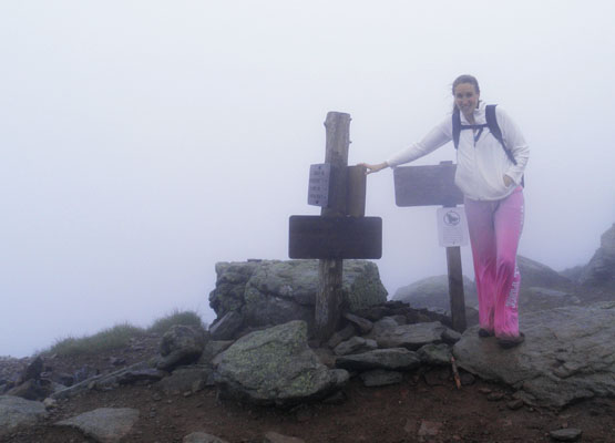
Top of Mount Lafayette on a very windy, rainy, foggy, hailing day! Photo taken on June 26, 2010. |
| |
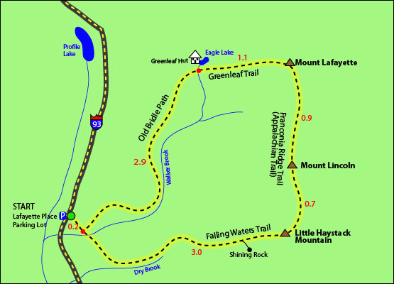
| Mount Lafayette Trail Maps - Directions from the parking lot to the summit |
The map below shows how to get to the summit of Mount Lafayette, as well as Mount Lincoln and Little Haystack Mountain by a loop hike, but you could also hike Mount Lafayette by itself and retrace your steps back to the parking lot, eliminating Mount Lafayette and Little Haystack Mountain for a shorter hike.
This loop hike begins and ends on Old Bridle Path from the Lafayette Place parking lot. You begin hiking on Old Bridle Path for 0.2 miles until you reach a fork where you will want to stay right onto Falling Waters Trail. Follow for 3 miles where you will find yourself on the summit of Little Haystack Mountain. (If you would like to get a great view of Franconia Notch before reaching any summits, turn right down a 100 yard spur trail leading to Shining Rock after being on Falling Waters Trail for 2.6 miles. This ledge provides excellent views, but also be careful on a rainy day, it can be very slippery.) From Little Haystack Mountains's summit, turn left to Franconia Ridge Trail (which is also part of the Appalachian Trail) and continue along for 0.7 miles until you reach the summit of Mount Lincoln. (here you can decide whether to continue the loop hike by heading over to Mount Lafayette, or by retracing your steps back to the parking lot to end your hike.) To continue the loop hike, you will keep following the Franconia Ridge Trail for 0.9 miles until you reach the summit of Mount Lafayette. To start your desent down to the parking lot, turn left onto the Greenleaf Trail. After 1.1 miles you will reach Eagle Lake and the Greeleaf Hut (where you can grab some food and drink, as well as use the restrooms). Turn left to get onto Old Bridle Path and contiune your hike down for 3.1 miles until you reach the parking lot you began at.
Click to download PDF Trail Map of Mount Lafayette
|
| |
| Mount Lafayette View Photos |
|
| |
| Mount Lafayette Driving Directions |
The parking lot for this hike is located in Franconia Notch on I-93. You can park on either side of the Interstate, because there is a foot tunnel connecting the two.
If you are traveling North on I-93
Take the first exit after The Basin. After passing The Basin's parking lot, you will see a sign for Trailhead parking 1/4 mile, this is where you should park.
If you are traveling South on I-93
Take the first exit after 34B called Lafayette Place Campground Trailhead Parking. To begin the hike, follow the foot tunnel under I-93 to the parking lot on the opposite side of the highway. |
| |
| On this page: Information | Trail maps | View Photos | Driving Directions |
|
|