| View all NH 4,000 Footers |
| Mount Adams |
| Mount Bond |
| Bondcliff |
| Mount Bond, West Peak |
| Mount Cabot |
| Cannon Mountain |
| Mount Carrigain |
| Carter Dome |
| Carter, Middle |
| Carter, South |
| Mount Eisenhower |
| Mount Field |
| Mount Flume |
| Mount Galehead |
| Mount Garfield |
| Mount Hale |
| Mount Hancock |
| Mount Hancock, South Peak |
| Mount Isolation |
| Mount Jackson |
| Mount Jefferson |
| Mount Kinsman, North Peak |
| Mount Kinsman, South Peak |
| Mount Lafayette |
| Mount Liberty |
| Mount Lincoln |
| Mount Madison |
| Mount Monroe |
| Mount Moosilauke |
| Mount Moriah |
| Mount Osceola |
| Mount Osceola, East Peak |
| Owl's Head |
| Mount Passaconway |
| Mount Pierce |
| Mount Tecumseh |
| Mount Tom |
| Mount Tripyramid, Middle Peak |
| Mount Tripyramid, North Peak |
| Mount Twin, North Peak |
| Mount Twin, South Peak |
| Mount Washington |
| Mount Waumbek |
| Mount Whiteface |
| Mount Wildcat, A Peak |
| Mount Wildcat, D Peak |
| Mount Willey |
| Zealand Mountain |
| NH Mountain Ranges/ Areas ↓ |
| View all NH Mountain Ranges |
| Baldface-Royce Range |
| Carter-Moriah Range |
| Dartmouth Range |
| Franconia Range |
| Kinsman Range |
| Mahoosuc Range |
| Northern Ranges |
| Ossipee Mountains |
| Pemigewasset Wilderness |
| Pilot Range |
| Pliny Range |
| Presidential Range |
| Sandwich Range |
| Twin Range |
| Wapack Range |
| Willey Range |
|
|
Hiking Mount Adams |
| |
| On this page: Information | Trail maps | View Photos | Driving Directions |
| |
Elevation: 5,774 feet (1,760 meters)
Prominence:  804 feet (245 meters) 804 feet (245 meters)
Location: Low and Burbank's Grant, Thompson and Meserves Purchase, New Hampshire
Range: Presidential Range
Coordinates: 44°19'14" North 71°17'29" West
Rating: Difficult
Features: Rock Scrambles, Mossy Falls, Madison Spring Hut, Ice Caves, 360 degree views on a clear day, Alpine Zone, Star Lake, Peak Bagging
Distance of highlighted hike below: 10 miles with Mt. Madison (but you could always just hike Adams.) |
 |
Mount Adams is a 5,774 foot mountain in the Presidential Range of the White Mountains, making it the second highest mountain in New England after Mount Washington.
There are two major subsidiary peaks of Mount Adams: Mount Sam Adams (named after John Adams' cousin and Revolutionary Leader Samuel Adams) and Mount Quincy Adams, (named after President John Quincy Adams, Sam Adams' son).
The Northern side of Mount Adams is located in the town of Low and Burbank's Grant, NH, while the Southern side is located in Thompson and Meserve's Purchase, NH.
The Appalachian Trail traverses the area between Mount Adams and Mount Sam Adams on the Gulfside Trail.
The Randolph Mountain Club (RMC) maintains the trails and many shelters on the North side of Mount Adams including the Perch, Crag Camp, The Log Cabin and Gray Knob.
Mount Madison (5,367 feet) is a great mountain to Peak Bag Mount Adams with, because they are only 1.4 miles apart, but you have to take the weather conditions into consideration when deciding if this is right for you.
Mossy Falls are a great waterfall to visit on the way up to Mount Adams if you take the Short Line Trail. The Ice Caves are also a great alternative to "normal" hiking, as you have to make your way over, under and through tight squeezes in caves and giant boulders. When hiking on the Short Line Trail, you will see signs for the Subway which leads to and through the Ice Caves, then meets back up with the Short Line Trail. The Madison Spring Hut is 1.0 mile away from Mount Adams and 0.4 miles from Mount Madison.
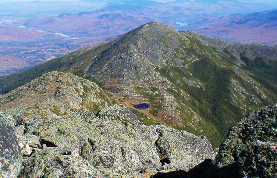
The views from the summit of Mount Adams. Looking at Mount Madison and Star Lake.
|
| |
| Mount Adams Trail Maps - Directions from the parking lot to the summit |
Top |
The map below shows how to get to the summit of Mount Adams and Mount Madison via the Appalachia Trail head Parking Lot.
There are many trail routes you can take to reach the summit of Mount Adams and Mount Madison, but the one below takes you by Mossy Falls, the Ice Caves, Star Lake and the Madison Spring Hut.
Begin at the Appalachia Trail head Parking Lot. The trails begin behind the wooden information booth. Stay right to begin the Air Line Trail for 0.9 miles. (You will cross an intersection about 0.2 miles into the hike for The Link, and Sylvan Way, then another intersection about 0.4 miles after that for Beechwood Way.) After you pass the Beechwood Way sign, stay slight right at the next intersection to cross over to Short Line Trail and continue for 1.9 miles until you reach Mossy Falls.
After enjoying Mossy Falls, continue up for 0.4 miles until you come to an intersection where you can go left to see the Ice Caves, or left for a slightly easier hike. (Each way till be 0.9 miles and meet up together at the Gulfside Trail.) Once you reach the Gulfside Trail sign you will see a sign pointing to Mount Adams. Continue up for 0.8 miles until you reach the summit.
After you are done at the top of Mount Adams, take the Star Lake Trail down to the Madison Spring Hut, passing Star Lake on your right. It will be 1 mile from Mount Adams to the hut. From the hut, take the Gulfside Trail up the bald rockyness of Mount Madison for 0.4 miles where you can enjoy great summit views on a clear day. Views of the Mount Washington Auto Road are also visible if you look just left of the direction of the Madison Spring Hut.
From Mount Madison, take the Watson Path for 1.5 mils (passing a junction at 0.3 miles with the Pine Link). Connect onto the Valley Way Trail and continue until you reach the parking lot, which is roughly 2.4 miles.
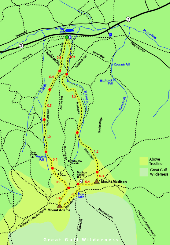
Click to download PDF Trail Map of Mount Madison and Mount Adams
|
| |
| |
|
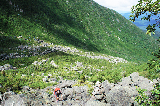
Photo of a hiker heading up the Air Line Trail on July 25, 2012
|
| Mount Adams Driving Directions |
Top |
From I-93
The parking lot for the above hike begins at the Appalachia Trail head Parking Lot. From I-93, take exit 35 (just North of Franconia Notch) or exit 40 if you're coming from the North. You will be on route 115 after exiting the highway. Follow it to route 2, where you will turn right. The parking lot is right on the road. It is a long parking lot, hard to miss. There are generally always cars parked there.
From Conway
Take route 16 North until it meets Route 2 in Gorham, NH where you will turn left. You will pass Dolly Copp road. The parking lot will be on the left.
|
|
On this page: Information | Trail maps | View Photos | Driving Directions | Top
|
|
|
|
|
|
|
|
|
|
|
|
|
|
|
|
| |
| |
|
| New Hampshire 4,000 Footers |
Vermont + Maine 4,000 Footers |
Other Hiking Lists / Patches |
New England Mountain Ranges |
Stay Involved in New England |
New Hampshire
Mount Adams
Mount Bond
Bondcliff
Mount Bond, West Peak
Mount Cabot
Cannon Mountain
Mount Carrigain
Carter Dome
Carter, Middle
Carter, South
Mount Eisenhower
Mount Field
Mount Flume
Mount Galehead
Mount Garfield
Mount Hale
Mount Hancock
Mount Hancock, South Peak
Mount Isolation
Mount Jackson
Mount Jefferson
Mount Kinsman, North Peak
Mount Kinsman, South Peak
Mount Lafayette
Mount Liberty
Mount Lincoln
Mount Madison
Mount Monroe
Mount Moosilauke
Mount Moriah
Mount Osceola
Mount Osceola, East Peak
Owl's Head
Mount Passaconway
Mount Pierce
Mount Tecumseh
Mount Tom
Mount Tripyramid, Middle Peak
Mount Tripyramid, North Peak
Mount Twin, North Peak
Mount Twin, South Peak
Mount Washington
Mount Waumbek
Mount Whiteface
Mount Wildcat, A Peak
Mount Wildcat, D Peak
Mount Willey
Zealand Mountain |
Vermont
Mount Abraham
Camel's Hump
Mount Ellen
Killington Peak
Mount Mansfield
Maine
Mount Abraham
Mount Bigelow, Avery Peak
Mount Bigelow, West Peak
Crocker Mountain
Crocker Mountain, South
Mount Katahdin, Baxter Peak
Mount Katahdin, Hamlin Peak
North Brother Mountain
Old Speck Mountain
Mount Redington
Saddleback Mountain
Saddleback Mountain, The Horn
Spaulding Mountain
Sugarloaf Mountain |
NH 4,000 footers
NH 4,000 footers in Winter
New England 4,000 footers
NE 4,000 footers in Winter
NH Hundred Highest
New England Fifty Finest
52 With a view
Trailwrights 72 summit club
New England Hundred highest
NE Hundred highest in Winter
Northeast 111
48x12 "The Grid"
Red Lining
Belknap Range
LRCT / Castle in the Clouds
NH Fire Tower Quest
Hike by - Alphabetically
Hike by - Elevation
Hike by - Prominence
Hike by - Mountain Range |
Ranges in New Hampshire
View all NH mountain ranges
Baldface-Royce Range
Carter-Moriah Range
Dartmouth Range
Franconia Range
Kinsman Range
Mahoosuc
Range
Ossipee Mountains
Northern Ranges
Pemigewasset Wilderness
Pilot Range
Pliny Range
Presidential Range
Sandwich Range
Twin Range
Wapack Range
Western White Mountains
Willey Range
Ranges in Maine
View all ME mountain ranges
Baxter State Park
High Peaks
Bigelow Range
Eastern White Mountains
Ranges in Vermont
Green Mountains
Other VT mountain ranges |
NH Waterfalls
NH AMC Huts
Hiker's store |
New England 4,000 Footers | NH 4,000 Footers | VT 4,000 Footers | ME 4,000 Footers | Hiking Lists & Patches | Hiker's Store | Contact by email
© www.4000footers.com 2015. All rights reserved. We are not affiliated with the AMC or the AMC Four Thousand Footer Club |
|
|


