|
|
|
Hiking Mount Redington |
| |
| On this page: Information | Trail maps | View Photos | Driving Directions |
| |
| Mount Redington Information |
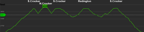
Elevation: 4,010 feet (1,222 meters)
Prominence:  440 feet (134 meters) 440 feet (134 meters)
Location: Redington, Maine (Franklin County)
Range: High Peaks
Coordinates: 45°1.50' North 70°23.32' West
Rating: Difficult
Features: Peak bag , no river crossings, bushwhack, Crocker Cirque Tentsite
Distance of highlighted hike below: 8.6 miles with Crocker Mountain, and South Crocker Mountain (or leave out Crocker making it 6.6 miles)
|
 |
Mount Redington is a 4,010 foot mountain in the High Peaks in Franklin County, Maine.
The Appalachian Trail, which spans from Georgia to Maine, is routed around Redington to go over Sugarloaf Mountain.
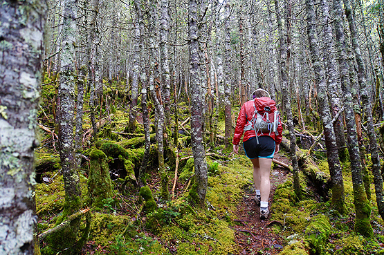
Mount Redington and Owl's Head in New Hampshire are the only 2 New England 4,000 Footers without maintained trails to the summits. But in reality, the trail to Owl's Head summit is so heavily hiked that the trail is obvious the entire way, while the trail to the summit of Mt. Redington is not as obvious. Since Mount Redington is on the Maine 4,000 footers list, so many people have hiked it, thus creating a herd path, which looks like a trail and is easy to follow in some areas, and difficult in others. The first half of this 1.20 mile stretch is a bit more tricky to stay on the path than the obvious second half heading up.
(NOTE THIS IS A BUSHWHACK HIKE. THERE IS NO MAINTAINED TRAIL TO THE SUMMIT OF REDINGTON, SO ONLY ATTEMPT THIS IF YOU ARE SMART WITH A NAVIGATION SYSTEM AND/OR KNOW WHAT YOU ARE DOING.)
There is a white canister on the summit strapped onto a tree that can be very hard to find. But if you find it, usually there is a notebook with little notes and names of the people who have summited it.
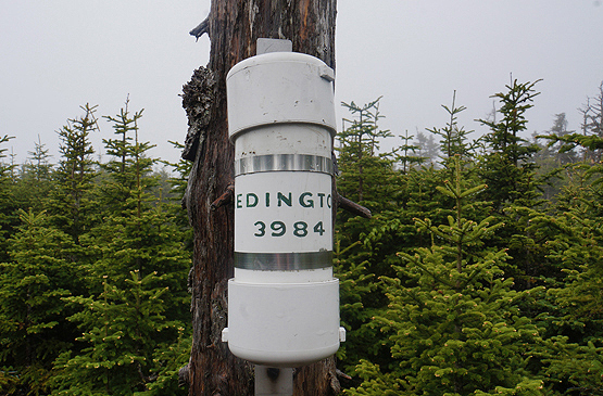
Canister on the summit of Redington on June 15, 2014.
|
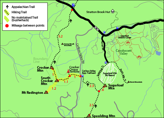
| Mount Redington Trail Maps - Directions from the parking lot to the summit |
Top |
The map below shows how to get to the summit of Mount Redington as well as Crocker Mountain, and South Crocker Mountain. (starting with the two Crockers, and Redington last)
From Caribou Valley Road in Carrabassett Valley, ME, the trail starts on the right side of the road if you are coming from Route 16 / 27. It can be hard to miss, but we built a cairn in June 2014 at the start of the trail to make it more visible from the road. When you are driving on the road, you will pass several bridges (two that are wood, and in terrible condition, and one that is metal right before a hill), so you will have to use your judgment whether or not your vehicle can drive over this. If you are able to drive to the trail head, there is a small clearing that can fit several cars about 50 feet before it where you can park. Some people prefer to park before the bridges and walk the rest.
From the trail head, where there is currently no sign on the road (but there is one that is easily missed about 20 feet in the trail up high), hike on the Appalachian Trail for 1.0 miles until you reach the turn for the Crocker Cirque Tentsite, which goes right. This first mile is easy. Flat and very little incline in some areas. From the tentsite junction, stay straight on the Appalachian Trail for another 1.1 miles where you will find yourself on the summit of South Crocker Mountain.
From the summit of S.Crocker, turn right to stay on the Appalachian Trail to head over to North Crocker Mountain. It is 1 mile away. This trail is relatively easy/moderate.
To add Mount Redington onto this hike, head back over to South Crocker Mountain.
(NOTE THIS IS A BUSHWHACK HIKE. THERE IS NO MAINTAINED TRAIL TO THE SUMMIT OF REDINGTON, SO ONLY ATTEMPT THIS IF YOU ARE SMART WITH A NAVIGATION SYSTEM AND/OR KNOW WHAT YOU ARE DOING.)
Near the summit of South Crocker Mountain, there is a viewpoint off to the left. If you are looking at the path to head up to the viewpoint, there is also a worn down path on your right. That is the path you will take to head over to Redington. While this hike is the only Maine 4,000 footer with no trail to the summit, so many people have already hiked it, that their foot prints have worn in a herd path. The herd path is certainly obvious in alot of areas where the path leads, and in other areas, it is not so obvious. After you begin the herd path, hike until you come to what looks like a junction with another overgrown trail (this is the boundary line trail). Go right onto this and hike a couple hundred feet where you will then turn left into the woods. (no sign). DO NOT CONTINUE HIKING ON THE BOUNDARY LINE. It is a rough path that is not meant for hikers. After your turn into the woods, you will hike on this herd path for just over a mile where you will reach the summit of Mount Redington.
To get back to the road, hike back over to South Crocker Mountain, then down the Appalachian Trail for 2.1 miles.
Rollover the map below for a closer view
Click to download PDF Trail Map of Mount Redington.
|
|
| |
| Mount Redington View Photos |
Top |
|
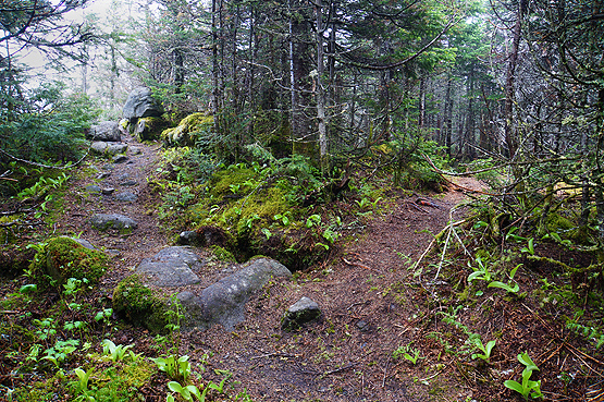
Photo of the viewpoint off South Crocker Mountain on the left, and the bushwhack herd path to Redington on the right on June 15, 2014.
This part of the herd path is tight and narrow, but quite obvious on June 15, 2014.
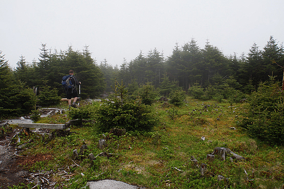
This is the open summit area of Mount Redington on June 15, 2014.
|
| Mount Redington Driving Directions |
Top |
To get to the trail head, take Route 27 northwest from the entrance to Sugarloaf ski area. It is roughly 1 mile from the Sugarloaf entrance to Caribou Valley Road (also called Caribou Pond Road) and will be on the left. This road was not signed in June 2014. The trail for this hike is 4.4 miles up the road. There is a small clearing for parking just before this.
When you are driving on the road, you will pass several bridges (two that are wood, and in terrible condition, and one that is metal right before a hill), so you will have to use your judgment whether or not your vehicle can drive over this, otherwise some people opt to park before the bridges and walk the rest.
Need a car spot or taxi?
There is a local small business called All Points Transportation run by a man named Greg in the Carrabassett Valley area who can help! If you need a car spot to a trailhead or for any other reason, give him a call to see if he is available. 207-329-3482. |
|
| |
On this page: Information | Trail maps | View Photos | Driving Directions | Top
|
|
|
|
|
|
| |
|
|
|
|
|
|
|
|
|
| |
| |
| New Hampshire 4,000 Footers |
Vermont + Maine 4,000 Footers |
Other Hiking Lists / Patches |
New England Mountain Ranges |
Stay Involved in New England |
New Hampshire
Mount Adams
Mount Bond
Bondcliff
Mount Bond, West Peak
Mount Cabot
Cannon Mountain
Mount Carrigain
Carter Dome
Carter, Middle
Carter, South
Mount Eisenhower
Mount Field
Mount Flume
Mount Galehead
Mount Garfield
Mount Hale
Mount Hancock
Mount Hancock, South Peak
Mount Isolation
Mount Jackson
Mount Jefferson
Mount Kinsman, North Peak
Mount Kinsman, South Peak
Mount Lafayette
Mount Liberty
Mount Lincoln
Mount Madison
Mount Monroe
Mount Moosilauke
Mount Moriah
Mount Osceola
Mount Osceola, East Peak
Owl's Head
Mount Passaconway
Mount Pierce
Mount Tecumseh
Mount Tom
Mount Tripyramid, Middle Peak
Mount Tripyramid, North Peak
Mount Twin, North Peak
Mount Twin, South Peak
Mount Washington
Mount Waumbek
Mount Whiteface
Mount Wildcat, A Peak
Mount Wildcat, D Peak
Mount Willey
Zealand Mountain |
Vermont
Mount Abraham
Camel's Hump
Mount Ellen
Killington Peak
Mount Mansfield
Maine
Mount Abraham
Mount Bigelow, Avery Peak
Mount Bigelow, West Peak
Crocker Mountain
Crocker Mountain, South
Mount Katahdin, Baxter Peak
Mount Katahdin, Hamlin Peak
North Brother Mountain
Old Speck Mountain
Mount Redington
Saddleback Mountain
Saddleback Mountain, The Horn
Spaulding Mountain
Sugarloaf Mountain |
NH 4,000 footers
NH 4,000 footers in Winter
New England 4,000 footers
NE 4,000 footers in Winter
NH Hundred Highest
New England Fifty Finest
52 With a view
Trailwrights 72 summit club
New England Hundred highest
NE Hundred highest in Winter
Northeast 111
48x12 "The Grid"
Red Lining
Belknap Range
LRCT / Castle in the Clouds
NH Fire Tower Quest
Hike by - Alphabetically
Hike by - Elevation
Hike by - Prominence
Hike by - Mountain Range |
Ranges in New Hampshire
View all NH mountain ranges
Baldface-Royce Range
Carter-Moriah Range
Dartmouth Range
Franconia Range
Kinsman Range
Mahoosuc
Range
Ossipee Mountains
Northern Ranges
Pemigewasset Wilderness
Pilot Range
Pliny Range
Presidential Range
Sandwich Range
Twin Range
Wapack Range
Western White Mountains
Willey Range
Ranges in Maine
View all ME mountain ranges
Baxter State Park
High Peaks
Bigelow Range
Eastern White Mountains
Ranges in Vermont
Green Mountains
Other VT mountain ranges |
NH Waterfalls
NH AMC Huts
Hiker's store |
New England 4,000 Footers | NH 4,000 Footers | VT 4,000 Footers | ME 4,000 Footers | Hiking Lists & Patches | Hiker's Store | Contact by email
© www.4000footers.com 2015. All rights reserved. We are not affiliated with the AMC or the AMC Four Thousand Footer Club |
|


