| View all NH 4,000 Footers |
| Mount Adams |
| Mount Bond |
| Bondcliff |
| Mount Bond, West Peak |
| Mount Cabot |
| Cannon Mountain |
| Mount Carrigain |
| Carter Dome |
| Carter, Middle |
| Carter, South |
| Mount Eisenhower |
| Mount Field |
| Mount Flume |
| Mount Galehead |
| Mount Garfield |
| Mount Hale |
| Mount Hancock |
| Mount Hancock, South Peak |
| Mount Isolation |
| Mount Jackson |
| Mount Jefferson |
| Mount Kinsman, North Peak |
| Mount Kinsman, South Peak |
| Mount Lafayette |
| Mount Liberty |
| Mount Lincoln |
| Mount Madison |
| Mount Monroe |
| Mount Moosilauke |
| Mount Moriah |
| Mount Osceola |
| Mount Osceola, East Peak |
| Owl's Head |
| Mount Passaconway |
| Mount Pierce |
| Mount Tecumseh |
| Mount Tom |
| Mount Tripyramid, Middle Peak |
| Mount Tripyramid, North Peak |
| Mount Twin, North Peak |
| Mount Twin, South Peak |
| Mount Washington |
| Mount Waumbek |
| Mount Whiteface |
| Mount Wildcat, A Peak |
| Mount Wildcat, D Peak |
| Mount Willey |
| Zealand Mountain |
| NH Mountain Ranges/ Areas ↓ |
| View all NH Mountain Ranges |
| Baldface-Royce Range |
| Carter-Moriah Range |
| Dartmouth Range |
| Franconia Range |
| Kinsman Range |
| Mahoosuc Range |
| Northern Ranges |
| Ossipee Mountains |
| Pemigewasset Wilderness |
| Pilot Range |
| Pliny Range |
| Presidential Range |
| Sandwich Range |
| Twin Range |
| Wapack Range |
| Willey Range |
|
|
Hike Mount Monroe |
| |
| On this page: Information | Trail maps | View Photos | Driving Directions |
| |
Elevation: 5,372 feet (1,637 meters)
Prominence:  254 feet (77 meters) 254 feet (77 meters)
Location: Thompson and Meserves Purchase, NH
Range: Presidential Range
Coordinates: 44°15'20" North 71°19'21" West
Rating: Difficult
Features: Alpine Zone , Waterfalls, Gorge, Peak Bagging ,
Lakes of the Clouds, Lakes of the Clouds Hut, , 360 Degree Views
Distance of highlighted hike below: 7 miles
|
 |
Mount Monroe is a 5,372 foot mountain in the Presidential Range of the White Mountains. It is the 4th highest mountain on the 4,000 footers official list of New Hampshire. There are 2 small lakes and a hut between Mount Monroe and Mount Washington called Lakes of the Clouds, and Lakes of the Clouds Hut. The summit offers 360 degree amazing views that include Mount washington and the rest of the Presidential Range Mountains.
|
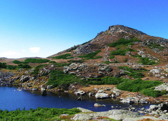
Looking at Mount Monroe and one of the Lakes of the Clouds. Photo taken on September 11, 2010. |
| |
| Mount Monroe Trail Maps - Directions from the parking lot to the summit |
Top |
The map below shows how to get to the summit of Mount Monroe, but also shown on the map: Mount Washington, Mount Franklin (not considered a 4,000 footer) and Mount Eisenhower.
You start on the Ammonoosuc Ravine Trail located in the parking area off of Base Road in Thompson and Meserves Purchase, NH. Hike 1 mile which is fairly flat, but rocky. You will come to a small junction with a 0.3 mile trail leading to Base Station. Stay right here to stay on the Ammonoosuc Ravine Trail. Continue for 1.1 miles where you will reach Gem Pool and its waterfall. Continue for 0.2 miles where you will see a sign for a gorge. Take that path on the right if you want to see am amazing set of 2 waterfalls side by side. (That path is only about 80 yards.) Once you get back on the Ammonoosuc Ravine Trail, hike up for 0.8 miles where you will find yourself at the Lakes of the Clouds Hut and the junction of the Crawford Path, which is also part of the Appalachian Trail. Follow the Crawford Path for 0.1 and bear right to go to the Mount Monroe Loop. The summit is only 0.3 miles from there. You can choose to descend Mount Monroe on either side of the loop trail pictured below.
You can choose to get back to your car in the parking lot by retracing your steps back down, or you can peak bag and hike Mount Washington.To do this, take the Crawford Path from the Lakes of the Clouds Hut towards the right for 1.5 miles to the summit.
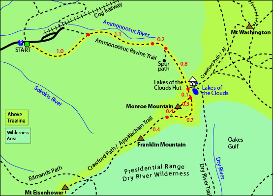
Click to download PDF Trail Map of Mount Monroe
|
| |
|
| |
|
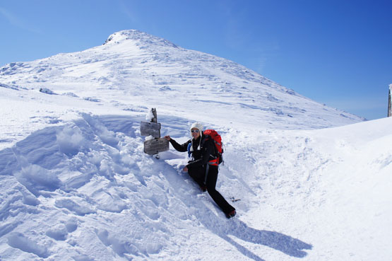
Looking up to Mount Monroe from the Lakes of the Clouds Hut in the Winter.
|
| Mount monroe Driving Directions |
Top |
The parking lot for this hike is located on Base Road in Thompson and Meserves Purchase, NH. From the junction of Route 3 and Route 302, head East on Route 302 for 5 miles. Turn left onto Base Road. (You will see a billboard for the Cog Railroad, and a restaurant on the corner.) Drive 5 miles and turn right into the WMNF parking area. Sometimes you can park up the hill, other times they require you to park at the bottom, and walk up. The trail begins up the paved road, behind all the buildings on the right side. It is signed. |
|
On this page: Information | Trail maps | View Photos | Driving Directions | Top
|
|
|
|
|
|
|
|
|
|
|
|
|
|
| |
| |
|
| New Hampshire 4,000 Footers |
Vermont + Maine 4,000 Footers |
Other Hiking Lists / Patches |
New England Mountain Ranges |
Stay Involved in New England |
New Hampshire
Mount Adams
Mount Bond
Bondcliff
Mount Bond, West Peak
Mount Cabot
Cannon Mountain
Mount Carrigain
Carter Dome
Carter, Middle
Carter, South
Mount Eisenhower
Mount Field
Mount Flume
Mount Galehead
Mount Garfield
Mount Hale
Mount Hancock
Mount Hancock, South Peak
Mount Isolation
Mount Jackson
Mount Jefferson
Mount Kinsman, North Peak
Mount Kinsman, South Peak
Mount Lafayette
Mount Liberty
Mount Lincoln
Mount Madison
Mount Monroe
Mount Moosilauke
Mount Moriah
Mount Osceola
Mount Osceola, East Peak
Owl's Head
Mount Passaconway
Mount Pierce
Mount Tecumseh
Mount Tom
Mount Tripyramid, Middle Peak
Mount Tripyramid, North Peak
Mount Twin, North Peak
Mount Twin, South Peak
Mount Washington
Mount Waumbek
Mount Whiteface
Mount Wildcat, A Peak
Mount Wildcat, D Peak
Mount Willey
Zealand Mountain |
Vermont
Mount Abraham
Camel's Hump
Mount Ellen
Killington Peak
Mount Mansfield
Maine
Mount Abraham
Mount Bigelow, Avery Peak
Mount Bigelow, West Peak
Crocker Mountain
Crocker Mountain, South
Mount Katahdin, Baxter Peak
Mount Katahdin, Hamlin Peak
North Brother Mountain
Old Speck Mountain
Mount Redington
Saddleback Mountain
Saddleback Mountain, The Horn
Spaulding Mountain
Sugarloaf Mountain |
NH 4,000 footers
NH 4,000 footers in Winter
New England 4,000 footers
NE 4,000 footers in Winter
NH Hundred Highest
New England Fifty Finest
52 With a view
Trailwrights 72 summit club
New England Hundred highest
NE Hundred highest in Winter
Northeast 111
48x12 "The Grid"
Red Lining
Belknap Range
LRCT / Castle in the Clouds
NH Fire Tower Quest
Hike by - Alphabetically
Hike by - Elevation
Hike by - Prominence
Hike by - Mountain Range |
Ranges in New Hampshire
View all NH mountain ranges
Baldface-Royce Range
Carter-Moriah Range
Dartmouth Range
Franconia Range
Kinsman Range
Mahoosuc
Range
Ossipee Mountains
Northern Ranges
Pemigewasset Wilderness
Pilot Range
Pliny Range
Presidential Range
Sandwich Range
Twin Range
Wapack Range
Western White Mountains
Willey Range
Ranges in Maine
View all ME mountain ranges
Baxter State Park
High Peaks
Bigelow Range
Eastern White Mountains
Ranges in Vermont
Green Mountains
Other VT mountain ranges |
NH Waterfalls
NH AMC Huts
Hiker's store |
New England 4,000 Footers | NH 4,000 Footers | VT 4,000 Footers | ME 4,000 Footers | Hiking Lists & Patches | Hiker's Store | Contact by email
© www.4000footers.com 2015. All rights reserved. We are not affiliated with the AMC or the AMC Four Thousand Footer Club |
|
|


