| View all NH 4,000 Footers |
| Mount Adams |
| Mount Bond |
| Bondcliff |
| Mount Bond, West Peak |
| Mount Cabot |
| Cannon Mountain |
| Mount Carrigain |
| Carter Dome |
| Carter, Middle |
| Carter, South |
| Mount Eisenhower |
| Mount Field |
| Mount Flume |
| Mount Galehead |
| Mount Garfield |
| Mount Hale |
| Mount Hancock |
| Mount Hancock, South Peak |
| Mount Isolation |
| Mount Jackson |
| Mount Jefferson |
| Mount Kinsman, North Peak |
| Mount Kinsman, South Peak |
| Mount Lafayette |
| Mount Liberty |
| Mount Lincoln |
| Mount Madison |
| Mount Monroe |
| Mount Moosilauke |
| Mount Moriah |
| Mount Osceola |
| Mount Osceola, East Peak |
| Owl's Head |
| Mount Passaconway |
| Mount Pierce |
| Mount Tecumseh |
| Mount Tom |
| Mount Tripyramid, Middle Peak |
| Mount Tripyramid, North Peak |
| Mount Twin, North Peak |
| Mount Twin, South Peak |
| Mount Washington |
| Mount Waumbek |
| Mount Whiteface |
| Mount Wildcat, A Peak |
| Mount Wildcat, D Peak |
| Mount Willey |
| Zealand Mountain |
| NH Mountain Ranges/ Areas ↓ |
| View all NH Mountain Ranges |
| Baldface-Royce Range |
| Carter-Moriah Range |
| Dartmouth Range |
| Franconia Range |
| Kinsman Range |
| Mahoosuc Range |
| Northern Ranges |
| Ossipee Mountains |
| Pemigewasset Wilderness |
| Pilot Range |
| Pliny Range |
| Presidential Range |
| Sandwich Range |
| Twin Range |
| Wapack Range |
| Willey Range |
|
|
Hike Wildcat Mountain, A Peak |
| |
| On this page: Information | Trail maps | View Photos | Driving Directions |
| |
| Wildcat Mountain, A Peak, Information |
Elevation: 4,422 feet (1,348 meters)
Prominence:  1,034 feet (315 meters) 1,034 feet (315 meters)
Location: Gorham, NH (Coös County, New Hampshire, USA)
Range: Carter-Moriah Range
Coordinates: 44°15'32" North 71°12'05" West
Rating: Moderate/Difficult
Features: Peak Bagging , Gondola, Glen Ellis Falls
Distance of highlighted hike below: 8.4 miles with Wildcat D
|
 |
Wildcat A Mountain, or just known as Wildcat Mountain is 4,422 feet tall with a prominence of 1,034 feet located in Gorham, New Hampshire in Coös County in the White Mountains on the East side of Pinkham Notch. It is one of 6 mountains in the Carter-Moriah Range along with Wildcat D Mountain.
Wildcat has 5 summits: A, B, C, D and E. Only A and D are considered part of the 4,000 footers. Summits B, C and E lack the 200 foot minimum topographic prominence to be considered a 4,000 footer. The E peak was formally believed to be taller than the D peak, and used to be on the official 4,000 footers list, but current topographic maps prove the D peak to be the taller summit.
This hike is a great opportunity to peak bag 2 official 4,000 footer mountains in one hike: Wildcat A and Wildcat D (along with B,C and E peaks). If you follow the highlighted portion of the trail below on the map, you can achieve this by following the Wildcat Ridge Trail from Route 16. After only 0.1 miles on the trail, you will reach Glen Ellis Falls. Between Peaks D and E, you will see the Wildcat Mountain Ski Area, which also has a gondola ride going to the bottom. (most often they won't let you ride it down because you are suppose to pay at the bottom first, but sometimes you can get lucky.)
The view from Wildcat A are not 360 degrees, but rather more like a 150 degree view from a lookout point. The view includes Carter-Dome Mountain, Carter Notch Hut and the Carter Lakes.
| For peak-baggers: |
Wildcat B Peak is roughly 0.8 miles from the summit of Wildcat A Mountain
Wildcat C Peak is roughly 1.5 miles from the summit of Wildcat A Mountain
Wildcat D Mountain is roughly 1.8 miles from the summit of Wildcat A Mountain
Carter Dome Mountain is 2.1 miles from the summit of Wildcat A Mountain
Wildcat E Peak is roughly 2.1 miles from the summit of Wildcat A Mountain
|
|
| Wildcat Mountain, A Peak, Trail Maps - Directions from the parking lot to the summit |
Top |
The map below shows how to get to the summit of Wildcat A Mountain as well as Wildcat B, C, D and E via an in-and-out hike on the Wildcat Ridge Trail (beginning and ending at the same parking lot). You could also get to Carter-Dome Mountain if you add an additional 2.1 miles each way.
You begin at the Glen Ellis Parking lot located in Gorham, New Hampshire on Route 16. From the parking lot you will cross under the road through the foot tunnel and cross over the Ellis River. Not even 0.1 miles into the hike you will come to a path on the right hand side leading to Glen Ellis Falls. You will want to go left and continue for 2.0 miles, where you will land in between Wildcat peaks E and D, and will get a good view of Wildcat Mountain Ski Area and the gondola ride. Continue up a rocky hill to Peak D, where there is a newly built lookout deck with a great view of Mount Washington. Continue along the Wildcat Ridge Trail for 1.2 miles where you will find yourself on the C peak. It is not marked, so you might not even realize you are there. From C peak, another 0.9 miles will bring you past B peak and onto Wildcat A peak. There is a sign for a viewing area on the right. There are great views of Carter-Dome Mountain, Carter Notch Hut and the Carter Lakes. To get back to the same parking lot, retrace your steps back 4.2 miles.
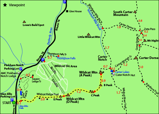
Click to download PDF Trail Map of Wildcat Mountain, A Peak
|
| |
|
| |
| Wildcat Mountain, A Peak, Photos |
Top |
|
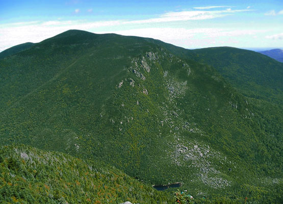
View from Wildcat Mountain. The Carter Notch Hut and Carter Lakes both visible. Taken on 8/28/10.
|
| Wildcat Mountain, A Peak, Driving Directions |
Top |
The parking lot for this hike is located in Gorham, New Hampshire on Route 16 in the Glen Ellis parking lot.
From the South heading North on I-93
Take exit 35 to merge onto US-3 N / Daniel Webster Highway towards Twin Mountain/Lancaster. Drive 10.3 miles and turn right on US-302 E / Dartmouth College Road. Continue for 29.1 miles and turn left at NH-16 N / Pinkham Notch Road and continue for 10.8 miles until you reach the parking lot on the right hand side of the road. There is a sign indicating Glen Ellis Falls.
From the West
Heading East on US-2, merge onto I-91 S via the ramp to the White River Junction. Take exit 19 after 2.3 miles to merge onto I-93 S towards Littleton, New Hampshire. Continue for 22.2 miles and take exit 40 for US-302/NH-10 E towards Bethlehem, Twin Mountain. Merge onto NH-10 N/NH-116 W/NH-18 S/US-302 E/Dartmouth College Road/Main Street. Continue for 40.1 miles and turn left at NH-16 N/Pinkham Notch Road. Continue 10.8 miles. The parking lot will be on the right hand side of the road. The parking lot is signed as Glen Ellis Falls. |
|
On this page: Information | Trail maps | View Photos | Driving Directions | Top
|
|
|
|
|
|
|
|
|
|
|
|
|
| |
| |
|
| New Hampshire 4,000 Footers |
Vermont + Maine 4,000 Footers |
Other Hiking Lists / Patches |
New England Mountain Ranges |
Stay Involved in New England |
New Hampshire
Mount Adams
Mount Bond
Bondcliff
Mount Bond, West Peak
Mount Cabot
Cannon Mountain
Mount Carrigain
Carter Dome
Carter, Middle
Carter, South
Mount Eisenhower
Mount Field
Mount Flume
Mount Galehead
Mount Garfield
Mount Hale
Mount Hancock
Mount Hancock, South Peak
Mount Isolation
Mount Jackson
Mount Jefferson
Mount Kinsman, North Peak
Mount Kinsman, South Peak
Mount Lafayette
Mount Liberty
Mount Lincoln
Mount Madison
Mount Monroe
Mount Moosilauke
Mount Moriah
Mount Osceola
Mount Osceola, East Peak
Owl's Head
Mount Passaconway
Mount Pierce
Mount Tecumseh
Mount Tom
Mount Tripyramid, Middle Peak
Mount Tripyramid, North Peak
Mount Twin, North Peak
Mount Twin, South Peak
Mount Washington
Mount Waumbek
Mount Whiteface
Mount Wildcat, A Peak
Mount Wildcat, D Peak
Mount Willey
Zealand Mountain |
Vermont
Mount Abraham
Camel's Hump
Mount Ellen
Killington Peak
Mount Mansfield
Maine
Mount Abraham
Mount Bigelow, Avery Peak
Mount Bigelow, West Peak
Crocker Mountain
Crocker Mountain, South
Mount Katahdin, Baxter Peak
Mount Katahdin, Hamlin Peak
North Brother Mountain
Old Speck Mountain
Mount Redington
Saddleback Mountain
Saddleback Mountain, The Horn
Spaulding Mountain
Sugarloaf Mountain |
NH 4,000 footers
NH 4,000 footers in Winter
New England 4,000 footers
NE 4,000 footers in Winter
NH Hundred Highest
New England Fifty Finest
52 With a view
Trailwrights 72 summit club
New England Hundred highest
NE Hundred highest in Winter
Northeast 111
48x12 "The Grid"
Red Lining
Belknap Range
LRCT / Castle in the Clouds
NH Fire Tower Quest
Hike by - Alphabetically
Hike by - Elevation
Hike by - Prominence
Hike by - Mountain Range |
Ranges in New Hampshire
View all NH mountain ranges
Baldface-Royce Range
Carter-Moriah Range
Dartmouth Range
Franconia Range
Kinsman Range
Mahoosuc
Range
Ossipee Mountains
Northern Ranges
Pemigewasset Wilderness
Pilot Range
Pliny Range
Presidential Range
Sandwich Range
Twin Range
Wapack Range
Western White Mountains
Willey Range
Ranges in Maine
View all ME mountain ranges
Baxter State Park
High Peaks
Bigelow Range
Eastern White Mountains
Ranges in Vermont
Green Mountains
Other VT mountain ranges |
NH Waterfalls
NH AMC Huts
Hiker's store |
New England 4,000 Footers | NH 4,000 Footers | VT 4,000 Footers | ME 4,000 Footers | Hiking Lists & Patches | Hiker's Store | Contact by email
© www.4000footers.com 2015. All rights reserved. We are not affiliated with the AMC or the AMC Four Thousand Footer Club |
|
|


