| View all NH 4,000 Footers |
| Mount Adams |
| Mount Bond |
| Bondcliff |
| Mount Bond, West Peak |
| Mount Cabot |
| Cannon Mountain |
| Mount Carrigain |
| Carter Dome |
| Carter, Middle |
| Carter, South |
| Mount Eisenhower |
| Mount Field |
| Mount Flume |
| Mount Galehead |
| Mount Garfield |
| Mount Hale |
| Mount Hancock |
| Mount Hancock, South Peak |
| Mount Isolation |
| Mount Jackson |
| Mount Jefferson |
| Mount Kinsman, North Peak |
| Mount Kinsman, South Peak |
| Mount Lafayette |
| Mount Liberty |
| Mount Lincoln |
| Mount Madison |
| Mount Monroe |
| Mount Moosilauke |
| Mount Moriah |
| Mount Osceola |
| Mount Osceola, East Peak |
| Owl's Head |
| Mount Passaconway |
| Mount Pierce |
| Mount Tecumseh |
| Mount Tom |
| Mount Tripyramid, Middle Peak |
| Mount Tripyramid, North Peak |
| Mount Twin, North Peak |
| Mount Twin, South Peak |
| Mount Washington |
| Mount Waumbek |
| Mount Whiteface |
| Mount Wildcat, A Peak |
| Mount Wildcat, D Peak |
| Mount Willey |
| Zealand Mountain |
| NH Mountain Ranges/ Areas ↓ |
| View all NH Mountain Ranges |
| Baldface-Royce Range |
| Carter-Moriah Range |
| Dartmouth Range |
| Franconia Range |
| Kinsman Range |
| Mahoosuc Range |
| Northern Ranges |
| Ossipee Mountains |
| Pemigewasset Wilderness |
| Pilot Range |
| Pliny Range |
| Presidential Range |
| Sandwich Range |
| Twin Range |
| Wapack Range |
| Willey Range |
|
|
Hike Mount Osceola |
| |
| On this page: Information | Trail maps | View Photos | Driving Directions |
| |
| Mount Osceola Information |
Elevation: 4,315 feet (1,315 meters)
Prominence:  2000 feet (610 meters) 2000 feet (610 meters)
Location: Lincoln, NH (Grafton County, New Hampshire)
Range: Sandwich Range
Coordinates: 44°0'5.81" North 71°32'8.21" West
Rating: Easy/Moderate
Features: Brooks, Cascades, Limited Summit View,
Peak Bagging  , Greeley Ponds , Greeley Ponds
Distance of highlighted hike below: 8.4 and 7.6 miles with East Osceola Mountain
|
 |
Mount Osceola is a 4,315 foot mountain located in Lincoln, New Hampshire in the White Mountains. It is one of 7 mountains in the Sandwich Range. The mountain is named after a Native American Tribe chief.
The views from the summit are not 360 degrees, but still amazing at around 220 degrees of clear views of Mount Washington in the Northeast and most of the rest of the White Mountains. There used to be a fire lookout tower at the summit, but was removed in the 1970s. The summit is a large rock slab which is perfect to grab lunch or hang out on!
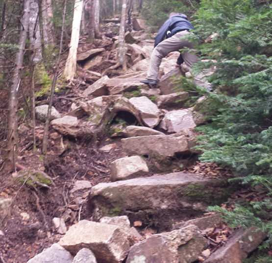
Though this hike is considered easy to moderate, if you choose to hike both Mount Osceola and East Osceola Mountain, the connecting trail between the 2 is more difficult with rock scrambles and areas where a less experienced hiker will need to use their hands, feet (and sometimes butt) to get over and around the rocks). The most challenging part between the two mountains is known as "The Chimney". It is almost vertical rock climbing, but there is a by-pass trail on the side of it to avoid the rocks.
|
| Mount Osceola Trail Maps - Directions from the parking lot to the summit |
Top |
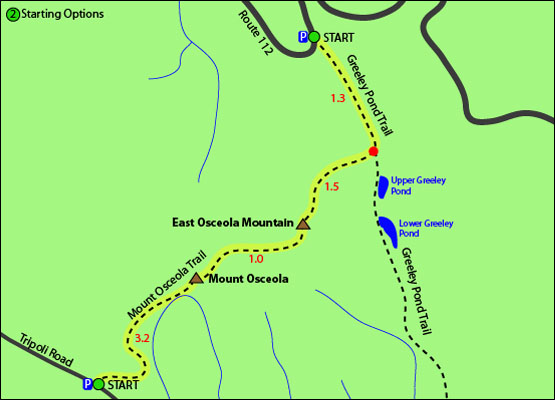
The map below shows how to get to the summit of Mount Osceola as well as East Osceola Mountain.
There are 2 different routes you can choose to hike Mount Osceola, one includes peak bagging it along with East Osceola Mountain.
To hike both mountains via Greeley Pond Parking area
Begin on the Greeley Pond Trail via the Kancamagus Highway (Route 112) in Lincoln, New Hampshire and hike for 1.3 miles until you come to a fork in the trail with Mount Osceola Trail, where you will bear right to switch trails. Follow this trail up for 1.5 miles to the summit of East Osceola Mountain. From there, continue over the summit on the Mount Osceola Trail for 1.0 miles where you will find yourself on the summit of Mount Osceola. To get back to the parking lot, retrace your steps the same way you came up.
To hike just Osceola Mountain via Tripoli Road parking area
Begin on the Mount Osceola Trail and hike for 3.2 miles where you will find yourself on the summit of Mount Osceola. To get back to the parking lot, retrace your steps back.
You can also summit both Osceola mountains by a traverse, making the hike 7 miles, but you would need a car spot at one of the parking areas.
Click to download PDF Trail Map of Osceola Mountain
|
| |
|
| |
|
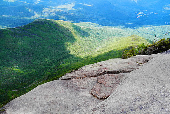
Photo taken near the summit of Osceola Mountain from the look-out ledges. Photo taken 6-30-2010.
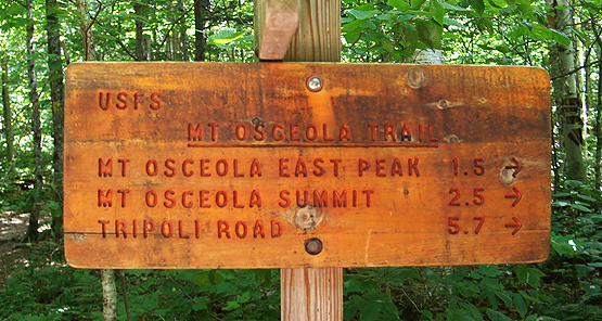
Trail sign on July 20, 2014.
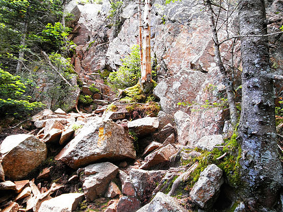
The "Chimney" on the Mount Osceola Trail between the 2 Osceola Mountains. Taken on 6-30-10.
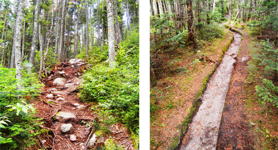
Parts of the Greeley Pond trail and the Mount Osceola Trail. Photo taken on June 30, 2010.
Greeley Pond trail. Photo taken by Andrew Kladder in November, 2014.
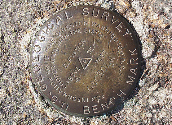
Summit benchmark on July 20, 2014.
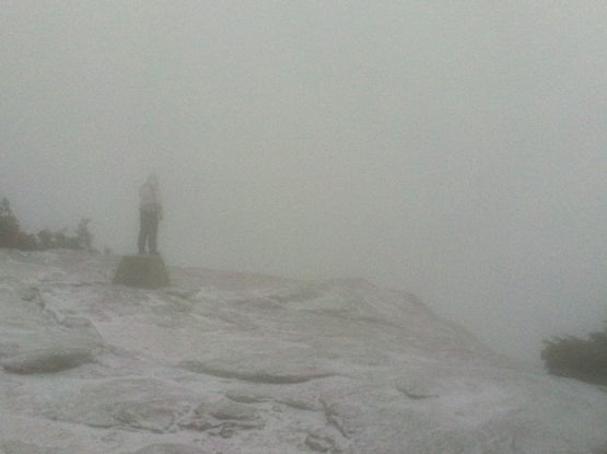
Photo taken near the summit of Osceola on the look-out ledges. Photo taken by Andrew Kladder in November, 2014.
|
| Mount Osceola Driving Directions |
Top |
There are 2 different parking lots you can park at for these hikes (refer to map above).
The parking lot to hike both Osceola mountains (via the shorter hike) is located on the Kancamagus Highway (Route 112) in Lincoln, New Hampshire.
From I-93, take exit 32 and follow the Kancamagus Highway (Route 112) for 9.7 miles East. The parking lot will be on the right hand side of the road, just after Big Rock Campground.
From Route 16 in Conway, New Hampshire, follow the Kancamagus Highway (Route 112) West for 26 miles. The parking lot will be on the left hand side of the road, just after the Hancock Overlook turn.
The parking lot to hike both Osceola mountains (via the longer hike) is located on Tripoli Road in Livermore, New Hampshire. From I-93 take exit 31, and head East off the exit onto Tripoli Road. Follow for 7 miles. The parking area is located on the left hand side of the road.
The parking lot to hike just East Osceola Mountain (via the shorter hike) is located on Tripoli Road in Livermore, New Hampshire. From I-93 take exit 31, and head East off the exit onto Tripoli Road. Follow for 7 miles. The parking area is located on the left hand side of the road. |
|
On this page: Information | Trail maps | View Photos | Driving Directions | Top
|
|
|
|
|
|
|
|
|
|
|
|
|
|
|
|
| |
| |
|
| New Hampshire 4,000 Footers |
Vermont + Maine 4,000 Footers |
Other Hiking Lists / Patches |
New England Mountain Ranges |
Stay Involved in New England |
New Hampshire
Mount Adams
Mount Bond
Bondcliff
Mount Bond, West Peak
Mount Cabot
Cannon Mountain
Mount Carrigain
Carter Dome
Carter, Middle
Carter, South
Mount Eisenhower
Mount Field
Mount Flume
Mount Galehead
Mount Garfield
Mount Hale
Mount Hancock
Mount Hancock, South Peak
Mount Isolation
Mount Jackson
Mount Jefferson
Mount Kinsman, North Peak
Mount Kinsman, South Peak
Mount Lafayette
Mount Liberty
Mount Lincoln
Mount Madison
Mount Monroe
Mount Moosilauke
Mount Moriah
Mount Osceola
Mount Osceola, East Peak
Owl's Head
Mount Passaconway
Mount Pierce
Mount Tecumseh
Mount Tom
Mount Tripyramid, Middle Peak
Mount Tripyramid, North Peak
Mount Twin, North Peak
Mount Twin, South Peak
Mount Washington
Mount Waumbek
Mount Whiteface
Mount Wildcat, A Peak
Mount Wildcat, D Peak
Mount Willey
Zealand Mountain |
Vermont
Mount Abraham
Camel's Hump
Mount Ellen
Killington Peak
Mount Mansfield
Maine
Mount Abraham
Mount Bigelow, Avery Peak
Mount Bigelow, West Peak
Crocker Mountain
Crocker Mountain, South
Mount Katahdin, Baxter Peak
Mount Katahdin, Hamlin Peak
North Brother Mountain
Old Speck Mountain
Mount Redington
Saddleback Mountain
Saddleback Mountain, The Horn
Spaulding Mountain
Sugarloaf Mountain |
NH 4,000 footers
NH 4,000 footers in Winter
New England 4,000 footers
NE 4,000 footers in Winter
NH Hundred Highest
New England Fifty Finest
52 With a view
Trailwrights 72 summit club
New England Hundred highest
NE Hundred highest in Winter
Northeast 111
48x12 "The Grid"
Red Lining
Belknap Range
LRCT / Castle in the Clouds
NH Fire Tower Quest
Hike by - Alphabetically
Hike by - Elevation
Hike by - Prominence
Hike by - Mountain Range |
Ranges in New Hampshire
View all NH mountain ranges
Baldface-Royce Range
Carter-Moriah Range
Dartmouth Range
Franconia Range
Kinsman Range
Mahoosuc
Range
Ossipee Mountains
Northern Ranges
Pemigewasset Wilderness
Pilot Range
Pliny Range
Presidential Range
Sandwich Range
Twin Range
Wapack Range
Western White Mountains
Willey Range
Ranges in Maine
View all ME mountain ranges
Baxter State Park
High Peaks
Bigelow Range
Eastern White Mountains
Ranges in Vermont
Green Mountains
Other VT mountain ranges |
NH Waterfalls
NH AMC Huts
Hiker's store |
New England 4,000 Footers | NH 4,000 Footers | VT 4,000 Footers | ME 4,000 Footers | Hiking Lists & Patches | Hiker's Store | Contact by email
© www.4000footers.com 2015. All rights reserved. We are not affiliated with the AMC or the AMC Four Thousand Footer Club |
|
|


