| View all NH 4,000 Footers |
| Mount Adams |
| Mount Bond |
| Bondcliff |
| Mount Bond, West Peak |
| Mount Cabot |
| Cannon Mountain |
| Mount Carrigain |
| Carter Dome |
| Carter, Middle |
| Carter, South |
| Mount Eisenhower |
| Mount Field |
| Mount Flume |
| Mount Galehead |
| Mount Garfield |
| Mount Hale |
| Mount Hancock |
| Mount Hancock, South Peak |
| Mount Isolation |
| Mount Jackson |
| Mount Jefferson |
| Mount Kinsman, North Peak |
| Mount Kinsman, South Peak |
| Mount Lafayette |
| Mount Liberty |
| Mount Lincoln |
| Mount Madison |
| Mount Monroe |
| Mount Moosilauke |
| Mount Moriah |
| Mount Osceola |
| Mount Osceola, East Peak |
| Owl's Head |
| Mount Passaconway |
| Mount Pierce |
| Mount Tecumseh |
| Mount Tom |
| Mount Tripyramid, Middle Peak |
| Mount Tripyramid, North Peak |
| Mount Twin, North Peak |
| Mount Twin, South Peak |
| Mount Washington |
| Mount Waumbek |
| Mount Whiteface |
| Mount Wildcat, A Peak |
| Mount Wildcat, D Peak |
| Mount Willey |
| Zealand Mountain |
| NH Mountain Ranges/ Areas ↓ |
| View all NH Mountain Ranges |
| Baldface-Royce Range |
| Carter-Moriah Range |
| Dartmouth Range |
| Franconia Range |
| Kinsman Range |
| Mahoosuc Range |
| Northern Ranges |
| Ossipee Mountains |
| Pemigewasset Wilderness |
| Pilot Range |
| Pliny Range |
| Presidential Range |
| Sandwich Range |
| Twin Range |
| Wapack Range |
| Willey Range |
|
|
Hike Cannon Mountain |
| |
| On this page: Information | Trail maps | View Photos | Driving Directions |
| |
| Cannon Mountain Information |
Elevation: 4,100 feet (1,250 meters)
Prominence:  740 feet (226 meters) 740 feet (226 meters)
Location: Franconia, Franconia Notch State Park, NH
Range: Kinsman Range
Coordinates: 44°9'23" North 71°41'54" West
Rating: Moderate / Difficult (Due to steep and loose dirt trail)
Features :Cannon Mountain Ski Area, Old Man of the Mountain Site, Shortest 4,000 Footer Hike
Distance of highlighted hike below: 4 miles, or 5.6 miles |
 |
Mount Cannon, formally known as Profile Mountain, is a 4,100 foot mountain located within Franconia Notch State Park of the White Mountains. It is in the Western White Mountains in the Kinsman Range. Cannon Mountain is home of the state-owned Cannon Mountain Ski Area, and used to be the home to the Old Man of the Mountain site until it collapsed on May 3, 2003. The mountain appears to be layered, like an onion, due to its exfoliating granite dome formation.
Cannon Mountain is also known for its difficult and technical rock climbing and ice climbing, mainly on the Cannon Cliff on the Southeast portion of the mountain. It is also the main mountain of a group of 3, called the Cannon Balls.
The shortest trail up to Cannon Mountain is the Hi-Cannon Trail from the Cannon Mountain Ski Area parking lot off I-93. The trail is a short 2 miles, but also very difficult due to its steep and loose dirt trail.
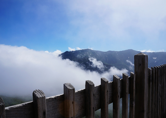
Cannon Mountain summit views. Photo taken on July 27, 2013.
|
| |
| |
| Cannon Mountain Trail Maps - Directions from the parking lot to the summit |
Top |
The map below shows how to get to the summit of Mount Cannon via the Kinsman Ridge Trail.
Begin on the Kinsman Ridge Trail from the Cannon Mountain Ski Area parking lot right off I-93, exit 34B. The trail is almost parallel to the Cannon Aerial Tram. Hike up for 2 miles until you reach the summit. There is a view point roughly 3/4 of the way up on the left. Descend by retracing your steps down the same trail.
Rollover map for an alternative route.
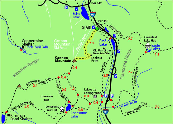 Click to download PDF Trail Map of Cannon Mountain Click to download PDF Trail Map of Cannon Mountain |
| |
| |
| Cannon Mountain Photos |
Top |
|
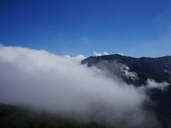
Views from the summit of Mount Cannon on a beautiful day. Photo taken on July 27, 2013.
|
| Cannon Mountain Driving Directions |
Top |
For the above mapped hike, the parking lot is located directly off of I-93 and is easy to find. Take exit 34B off I-93 where you will see a parking area for Cannon Mountain Ski Area (right after Profile Lakes if you are heading North, and right after Echo Lake if you are heading South.) The trail starts to the left of the Skiing buildings.
|
|
On this page: Information | Trail maps | View Photos | Driving Directions | Top
|
|
|
|
|
|
|
|
|
|
|
|
|
|
| |
|
| New Hampshire 4,000 Footers |
Vermont + Maine 4,000 Footers |
Other Hiking Lists / Patches |
New England Mountain Ranges |
Stay Involved in New England |
New Hampshire
Mount Adams
Mount Bond
Bondcliff
Mount Bond, West Peak
Mount Cabot
Cannon Mountain
Mount Carrigain
Carter Dome
Carter, Middle
Carter, South
Mount Eisenhower
Mount Field
Mount Flume
Mount Galehead
Mount Garfield
Mount Hale
Mount Hancock
Mount Hancock, South Peak
Mount Isolation
Mount Jackson
Mount Jefferson
Mount Kinsman, North Peak
Mount Kinsman, South Peak
Mount Lafayette
Mount Liberty
Mount Lincoln
Mount Madison
Mount Monroe
Mount Moosilauke
Mount Moriah
Mount Osceola
Mount Osceola, East Peak
Owl's Head
Mount Passaconway
Mount Pierce
Mount Tecumseh
Mount Tom
Mount Tripyramid, Middle Peak
Mount Tripyramid, North Peak
Mount Twin, North Peak
Mount Twin, South Peak
Mount Washington
Mount Waumbek
Mount Whiteface
Mount Wildcat, A Peak
Mount Wildcat, D Peak
Mount Willey
Zealand Mountain |
Vermont
Mount Abraham
Camel's Hump
Mount Ellen
Killington Peak
Mount Mansfield
Maine
Mount Abraham
Mount Bigelow, Avery Peak
Mount Bigelow, West Peak
Crocker Mountain
Crocker Mountain, South
Mount Katahdin, Baxter Peak
Mount Katahdin, Hamlin Peak
North Brother Mountain
Old Speck Mountain
Mount Redington
Saddleback Mountain
Saddleback Mountain, The Horn
Spaulding Mountain
Sugarloaf Mountain |
NH 4,000 footers
NH 4,000 footers in Winter
New England 4,000 footers
NE 4,000 footers in Winter
NH Hundred Highest
New England Fifty Finest
52 With a view
Trailwrights 72 summit club
New England Hundred highest
NE Hundred highest in Winter
Northeast 111
48x12 "The Grid"
Red Lining
Belknap Range
LRCT / Castle in the Clouds
NH Fire Tower Quest
Hike by - Alphabetically
Hike by - Elevation
Hike by - Prominence
Hike by - Mountain Range |
Ranges in New Hampshire
View all NH mountain ranges
Baldface-Royce Range
Carter-Moriah Range
Dartmouth Range
Franconia Range
Kinsman Range
Mahoosuc
Range
Ossipee Mountains
Northern Ranges
Pemigewasset Wilderness
Pilot Range
Pliny Range
Presidential Range
Sandwich Range
Twin Range
Wapack Range
Western White Mountains
Willey Range
Ranges in Maine
View all ME mountain ranges
Baxter State Park
High Peaks
Bigelow Range
Eastern White Mountains
Ranges in Vermont
Green Mountains
Other VT mountain ranges |
NH Waterfalls
NH AMC Huts
Hiker's store |
New England 4,000 Footers | NH 4,000 Footers | VT 4,000 Footers | ME 4,000 Footers | Hiking Lists & Patches | Hiker's Store | Contact by email
© www.4000footers.com 2015. All rights reserved. We are not affiliated with the AMC or the AMC Four Thousand Footer Club |
|
|


