| View all NH 4,000 Footers |
| Mount Adams |
| Mount Bond |
| Bondcliff |
| Mount Bond, West Peak |
| Mount Cabot |
| Cannon Mountain |
| Mount Carrigain |
| Carter Dome |
| Carter, Middle |
| Carter, South |
| Mount Eisenhower |
| Mount Field |
| Mount Flume |
| Mount Galehead |
| Mount Garfield |
| Mount Hale |
| Mount Hancock |
| Mount Hancock, South Peak |
| Mount Isolation |
| Mount Jackson |
| Mount Jefferson |
| Mount Kinsman, North Peak |
| Mount Kinsman, South Peak |
| Mount Lafayette |
| Mount Liberty |
| Mount Lincoln |
| Mount Madison |
| Mount Monroe |
| Mount Moosilauke |
| Mount Moriah |
| Mount Osceola |
| Mount Osceola, East Peak |
| Owl's Head |
| Mount Passaconway |
| Mount Pierce |
| Mount Tecumseh |
| Mount Tom |
| Mount Tripyramid, Middle Peak |
| Mount Tripyramid, North Peak |
| Mount Twin, North Peak |
| Mount Twin, South Peak |
| Mount Washington |
| Mount Waumbek |
| Mount Whiteface |
| Mount Wildcat, A Peak |
| Mount Wildcat, D Peak |
| Mount Willey |
| Zealand Mountain |
| NH Mountain Ranges/ Areas ↓ |
| View all NH Mountain Ranges |
| Baldface-Royce Range |
| Carter-Moriah Range |
| Dartmouth Range |
| Franconia Range |
| Kinsman Range |
| Mahoosuc Range |
| Northern Ranges |
| Ossipee Mountains |
| Pemigewasset Wilderness |
| Pilot Range |
| Pliny Range |
| Presidential Range |
| Sandwich Range |
| Twin Range |
| Wapack Range |
| Willey Range |
|
|
Hike South Kinsman Mountain |
| |
| On this page: Information | Trail maps | View Photos | Driving Directions |
| |
| Kinsman South Information |
Elevation: 4,358 feet (1,328 meters)
Prominence:  2,240 feet (683 meters) 2,240 feet (683 meters)
Location: Franconia, NH (Grafton County)
Range: Kinsman Range
Coordinates: 44°7.38' North 71°44.20' West
Rating: Difficult
Features: Cascades, Rock Scrambles , Peak Bagging , Lonesome Lake Hut, Lonesome Lake, Kinsman Pond, Kinsman Pond Shelter, Appalachian Trail
Distance of highlighted hike below: 11.2 miles with North Kinsman Mountain
|
 |
South Kinsman Mountain is a 4,358' (683 m) mountain in the Kinsman Range in Franconia, NH, Grafton County. It is part of the Western White Mountains.
The mountain is named after Nathan Kinsman, who was an early resident of Easton, NH. This mountain, along with North Kinsman Mountain, are both considered 4,000 footers because there is more than 200 feet of topographic prominence between the two.
Because it is the highest point between Franconia Notch and the Kinsman Notch, South Kinsman Mountain is the sixth most prominent mountain of the White Mountains.
There is no views to look at on the summit of South Kinsman Mountain because trees are in the way.
|
| Kinsman South Trail Maps - Directions from the parking lot to the summit |
Top |
The trail map below shows how to get to the summit of North and South Kinsman Mountains.
Begin at the Lafayette Place Parking Lot. Hike along the Lonesome Lake Trail for 0.4 miles until you reach a fork, where you will bare left to stay on the same trail for 0.8 miles. Hike along the Cascade Brook Trail around Lonesome Lake for 0.3 miles until you see a sign to switch over to the Fishin' Jimmy Trail. (You will see signs for the Lonesome Lake Hut here. Take a stop in if you wish!) Hike up the Fishin' Jimmy Trail for 2.2 miles. (crossing over the junction with the Kinsman Pond Trail.) Turn left onto the Kinsman Ridge Trail, which is also the Appalachian Trail, and hike for 0.4 miles until you reach the summit of North Kinsman Mountain.
After enjoying the views on North Kinsman, continue hiking over the summit along the Kinsman Ridge Trail for 0.9 miles where you will reach the summit of South Kinsman Mountain.
To head back tot he Lafayette Place parking lot, you can retrace your steps the same way you came up, or switch some of the trails up for fun by taking the Kinsman Pond Trail instead of the Fishin' Jimmy Trail. Then turn left to hike along the Cascade Brook Trail for 0.8 miles back to the Lonesome Lake area, and continue the last 1.5 miles the same way you hiked in.
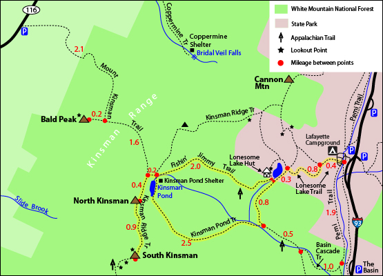
Rollover map above for a closer view. Click to download PDF Trail Map of North and South Kinsman
|
| |
| |
|
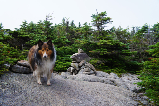
Rock cairn on the summit of Kinsman South Mountain on August 5, 2012.
|
| Kinsman South Driving Directions |
Top |
The parking lot for the highlighted hike above is at the Lafayette Place Campground parking area. It is exit 34B off I-93. If you are coming from the South, you will need to turn left back onto I-93 South after taking exit 34B. Drive 2.1 miles on I-93 South then take the exit towards the Lafayette Place Campground / Railhead Parking. Merge onto the Recreational Trail. Turn left onto Lafayette Campground.
|
|
On this page: Information | Trail maps | View Photos | Driving Directions | Top
|
|
|
|
|
|
|
|
|
|
|
|
|
|
| |
| |
|
| New Hampshire 4,000 Footers |
Vermont + Maine 4,000 Footers |
Other Hiking Lists / Patches |
New England Mountain Ranges |
Stay Involved in New England |
New Hampshire
Mount Adams
Mount Bond
Bondcliff
Mount Bond, West Peak
Mount Cabot
Cannon Mountain
Mount Carrigain
Carter Dome
Carter, Middle
Carter, South
Mount Eisenhower
Mount Field
Mount Flume
Mount Galehead
Mount Garfield
Mount Hale
Mount Hancock
Mount Hancock, South Peak
Mount Isolation
Mount Jackson
Mount Jefferson
Mount Kinsman, North Peak
Mount Kinsman, South Peak
Mount Lafayette
Mount Liberty
Mount Lincoln
Mount Madison
Mount Monroe
Mount Moosilauke
Mount Moriah
Mount Osceola
Mount Osceola, East Peak
Owl's Head
Mount Passaconway
Mount Pierce
Mount Tecumseh
Mount Tom
Mount Tripyramid, Middle Peak
Mount Tripyramid, North Peak
Mount Twin, North Peak
Mount Twin, South Peak
Mount Washington
Mount Waumbek
Mount Whiteface
Mount Wildcat, A Peak
Mount Wildcat, D Peak
Mount Willey
Zealand Mountain |
Vermont
Mount Abraham
Camel's Hump
Mount Ellen
Killington Peak
Mount Mansfield
Maine
Mount Abraham
Mount Bigelow, Avery Peak
Mount Bigelow, West Peak
Crocker Mountain
Crocker Mountain, South
Mount Katahdin, Baxter Peak
Mount Katahdin, Hamlin Peak
North Brother Mountain
Old Speck Mountain
Mount Redington
Saddleback Mountain
Saddleback Mountain, The Horn
Spaulding Mountain
Sugarloaf Mountain |
NH 4,000 footers
NH 4,000 footers in Winter
New England 4,000 footers
NE 4,000 footers in Winter
NH Hundred Highest
New England Fifty Finest
52 With a view
Trailwrights 72 summit club
New England Hundred highest
NE Hundred highest in Winter
Northeast 111
48x12 "The Grid"
Red Lining
Belknap Range
LRCT / Castle in the Clouds
NH Fire Tower Quest
Hike by - Alphabetically
Hike by - Elevation
Hike by - Prominence
Hike by - Mountain Range |
Ranges in New Hampshire
View all NH mountain ranges
Baldface-Royce Range
Carter-Moriah Range
Dartmouth Range
Franconia Range
Kinsman Range
Mahoosuc
Range
Ossipee Mountains
Northern Ranges
Pemigewasset Wilderness
Pilot Range
Pliny Range
Presidential Range
Sandwich Range
Twin Range
Wapack Range
Western White Mountains
Willey Range
Ranges in Maine
View all ME mountain ranges
Baxter State Park
High Peaks
Bigelow Range
Eastern White Mountains
Ranges in Vermont
Green Mountains
Other VT mountain ranges |
NH Waterfalls
NH AMC Huts
Hiker's store |
New England 4,000 Footers | NH 4,000 Footers | VT 4,000 Footers | ME 4,000 Footers | Hiking Lists & Patches | Hiker's Store | Contact by email
© www.4000footers.com 2015. All rights reserved. We are not affiliated with the AMC or the AMC Four Thousand Footer Club |
|
|


