| View all NH 4,000 Footers |
| Mount Adams |
| Mount Bond |
| Bondcliff |
| Mount Bond, West Peak |
| Mount Cabot |
| Cannon Mountain |
| Mount Carrigain |
| Carter Dome |
| Carter, Middle |
| Carter, South |
| Mount Eisenhower |
| Mount Field |
| Mount Flume |
| Mount Galehead |
| Mount Garfield |
| Mount Hale |
| Mount Hancock |
| Mount Hancock, South Peak |
| Mount Isolation |
| Mount Jackson |
| Mount Jefferson |
| Mount Kinsman, North Peak |
| Mount Kinsman, South Peak |
| Mount Lafayette |
| Mount Liberty |
| Mount Lincoln |
| Mount Madison |
| Mount Monroe |
| Mount Moosilauke |
| Mount Moriah |
| Mount Osceola |
| Mount Osceola, East Peak |
| Owl's Head |
| Mount Passaconway |
| Mount Pierce |
| Mount Tecumseh |
| Mount Tom |
| Mount Tripyramid, Middle Peak |
| Mount Tripyramid, North Peak |
| Mount Twin, North Peak |
| Mount Twin, South Peak |
| Mount Washington |
| Mount Waumbek |
| Mount Whiteface |
| Mount Wildcat, A Peak |
| Mount Wildcat, D Peak |
| Mount Willey |
| Zealand Mountain |
| NH Mountain Ranges/ Areas ↓ |
| View all NH Mountain Ranges |
| Baldface-Royce Range |
| Carter-Moriah Range |
| Dartmouth Range |
| Franconia Range |
| Kinsman Range |
| Mahoosuc Range |
| Northern Ranges |
| Ossipee Mountains |
| Pemigewasset Wilderness |
| Pilot Range |
| Pliny Range |
| Presidential Range |
| Sandwich Range |
| Twin Range |
| Wapack Range |
| Willey Range |
|
|
Hike Mount Carrigain |
| |
| On this page: Information | Trail maps | View Photos | Driving Directions |
| |
| Mount Carrigain Information |
Elevation: 4,700 feet (1,433 meters)
Prominence:  2,240 feet (683 meters) 2,240 feet (683 meters)
Location: Livermore, NH (Grafton County)
Range: Pemigewasset Wilderness
Coordinates: 44°05'36" North 71°26'51" West
Rating: 1st two miles are Easy, the last 3 miles are Moderate
Features: Carrigain Brook, Summit fire tower, 360° views
Distance of highlighted hike below: 10 miles
|
 |
Mount Carrigain is a 4,700 foot mountain located in Livermore, New Hampshire. It is located in the Pemigewasset Wilderness in the White Mountains. The mountain is named after Phillip Carrigain, New Hampshire's Secretary of State from 1805-1810. One of the sub peaks of Carrigain is Vose Spur, which is on the New England Hundred Highest hiking list.
The summit has a fire tower providing 360° views of the Pemigewasset Wilderness on a clear day. The first ascent up Mount Carrigain was on August 27, 1857. There is a few stunning viewpoints along the trail.
|
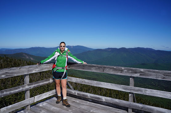
Summit of Mount Carrigain on June 5, 2013. |
|
| Mount Carrigain Trail Maps - Directions from the parking lot to the summit |
Top |
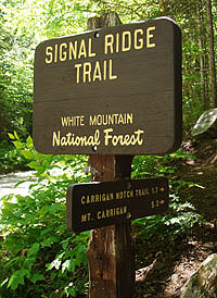
The trail map below shows how to get to the summit of Mount Carrigain via the Signal Ridge Trail.
From the parking lot on Sawyer River Road, head up the Signal Ridge Trail for 1.7 miles until you come to a junction with the Carrigain Notch Trail. Continue up the Signal Ridge Trail for 3.3 miles by bearing left at the junction where you will reach the summit of Mount Carrigain. Retrace your steps to get back down to the parking lot.
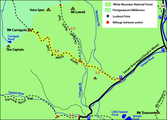
Click to download PDF Trail Map of Mount Carrigain
|
| |
|
| Mount Carrigain Photos |
Top |
|
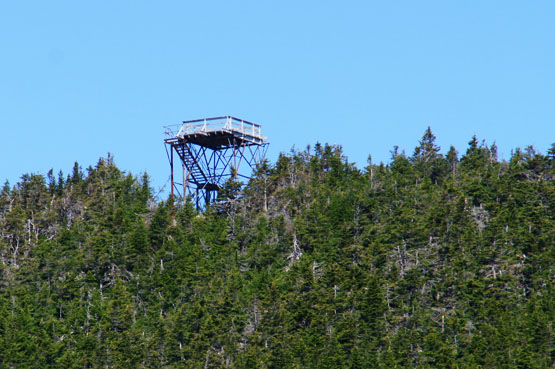
Fire Tower on the summit of Mount Carrigain June 5, 2013.
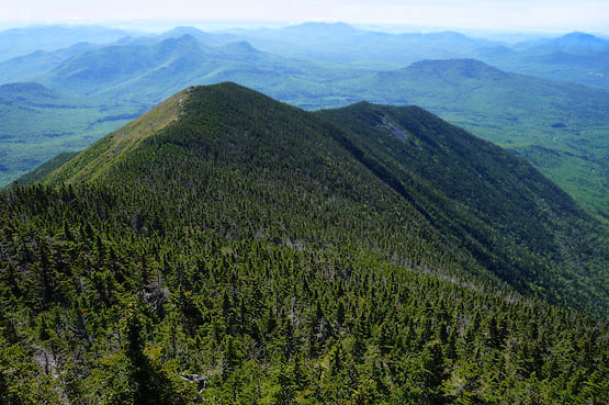
That is what you will hike over before reaching the summit of Mt. Carrigain if you go up the Signal Ridge Trail.
|
| Mount Carrigain Driving Directions |
Top |
The parking lot for the highlighted hike above is located on Sawyer River Road in Livermore, NH. (Some GPSs won't have Livermore, New Hampshire programmed in.)
Take exit 35 off I-93 South. Head North on Route 3 towards Twin Mountain / Lancaster. Drive 10.3 miles and turn right onto Route 302 East. Drive 19 miles on Route 302 until you reach Sawyer River Road. Drive roughly 2 miles until you reach a parking lot on the left side for the Signal Ridge Trail. It is a dirt road that is closed in the Winter.
The Signal Ridge Trail begins across the street from the parking lot. The first 2 miles of this hike are relatively easy, but the difficulty picks up after that for the remaining 3 miles up to the summit of Mount Carrigain. |
|
 |
|
|
On this page: Information | Trail maps | View Photos | Driving Directions | Top
|
|
|
|
|
|
|
|
|
|
|
|
|
|
|
| |
|
| New Hampshire 4,000 Footers |
Vermont + Maine 4,000 Footers |
Other Hiking Lists / Patches |
New England Mountain Ranges |
Stay Involved in New England |
New Hampshire
Mount Adams
Mount Bond
Bondcliff
Mount Bond, West Peak
Mount Cabot
Cannon Mountain
Mount Carrigain
Carter Dome
Carter, Middle
Carter, South
Mount Eisenhower
Mount Field
Mount Flume
Mount Galehead
Mount Garfield
Mount Hale
Mount Hancock
Mount Hancock, South Peak
Mount Isolation
Mount Jackson
Mount Jefferson
Mount Kinsman, North Peak
Mount Kinsman, South Peak
Mount Lafayette
Mount Liberty
Mount Lincoln
Mount Madison
Mount Monroe
Mount Moosilauke
Mount Moriah
Mount Osceola
Mount Osceola, East Peak
Owl's Head
Mount Passaconway
Mount Pierce
Mount Tecumseh
Mount Tom
Mount Tripyramid, Middle Peak
Mount Tripyramid, North Peak
Mount Twin, North Peak
Mount Twin, South Peak
Mount Washington
Mount Waumbek
Mount Whiteface
Mount Wildcat, A Peak
Mount Wildcat, D Peak
Mount Willey
Zealand Mountain |
Vermont
Mount Abraham
Camel's Hump
Mount Ellen
Killington Peak
Mount Mansfield
Maine
Mount Abraham
Mount Bigelow, Avery Peak
Mount Bigelow, West Peak
Crocker Mountain
Crocker Mountain, South
Mount Katahdin, Baxter Peak
Mount Katahdin, Hamlin Peak
North Brother Mountain
Old Speck Mountain
Mount Redington
Saddleback Mountain
Saddleback Mountain, The Horn
Spaulding Mountain
Sugarloaf Mountain |
NH 4,000 footers
NH 4,000 footers in Winter
New England 4,000 footers
NE 4,000 footers in Winter
NH Hundred Highest
New England Fifty Finest
52 With a view
Trailwrights 72 summit club
New England Hundred highest
NE Hundred highest in Winter
Northeast 111
48x12 "The Grid"
Red Lining
Belknap Range
LRCT / Castle in the Clouds
NH Fire Tower Quest
Hike by - Alphabetically
Hike by - Elevation
Hike by - Prominence
Hike by - Mountain Range |
Ranges in New Hampshire
View all NH mountain ranges
Baldface-Royce Range
Carter-Moriah Range
Dartmouth Range
Franconia Range
Kinsman Range
Mahoosuc
Range
Ossipee Mountains
Northern Ranges
Pemigewasset Wilderness
Pilot Range
Pliny Range
Presidential Range
Sandwich Range
Twin Range
Wapack Range
Western White Mountains
Willey Range
Ranges in Maine
View all ME mountain ranges
Baxter State Park
High Peaks
Bigelow Range
Eastern White Mountains
Ranges in Vermont
Green Mountains
Other VT mountain ranges |
NH Waterfalls
NH AMC Huts
Hiker's store |
New England 4,000 Footers | NH 4,000 Footers | VT 4,000 Footers | ME 4,000 Footers | Hiking Lists & Patches | Hiker's Store | Contact by email
© www.4000footers.com 2015. All rights reserved. We are not affiliated with the AMC or the AMC Four Thousand Footer Club |
|
|


