|
|
|
Hike Camel's Hump |
| |
| On this page: Information | Trail maps | View Photos | Driving Directions |
| |
Elevation: 4,083 feet (1,244 meters)
Prominence:  1,860 feet (567 meters) 1,860 feet (567 meters)
Location: Huntington and Duxbury, Vermont
Range: Green Mountains
Coordinates: 44°19'10.37" North 72°53'10.78" West
Rating: Moderate
Features: Long Trail, plane crash site, Burrows Trail
Distance of highlighted hike below: 5.6 miles
|
 |
Camel's Hump is the third highest peak in the Green Mountains of Vermont at 4,083 feet. This mountain is featured on the US Vermont quarter, because of the distinct appearance of the mountain.
In October 1944 during World War II, a B-27J Bomber plane on a training mission crashed into the side of the mountain near the summit. Most of the wreckage has been removed, but parts of a wing still exist on the Alpine Trail just about 0.4 miles from the summit. (Rollover the map below to see where the plane crash site is, where you can still see remains to this day.)
The shortest route up to the summit of Camel's Hump is via the Burrows Trail. This hike is 4.8 miles roundtrip from the Burrows Trail parking lot on Camels Hump Road.
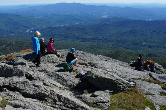
Summit of Camel's Hump on September 7, 2014.
|
| Camel's Hump Trail Maps - Directions from the parking lot to the summit |
Top |
The map below shows how to get to the summit of Camel's Hump.
Starting at the Burrows trail parking lot off Camels Hump Road, hike up the Burrows trail for 2.1 miles where you will come to a junction with the Long Trail. Turn right onto the Long Trail and hike for 0.3 miles where you will find yourself on the summit of Camels Hump.
To continue on to the 1944 plane crash site, continue over the summit on the Long Trail for 0.2 more miles until you reach a junction with the Alpine Trail. Turn left to the Alpine Trail and hike for roughly 0.2 miles and you will find yourself at the plane crash site.
To get back down to the parking lot, retrace your steps back the way you came.
Rollover the map below to see a zoomed in area of the 1944 plane crash site.
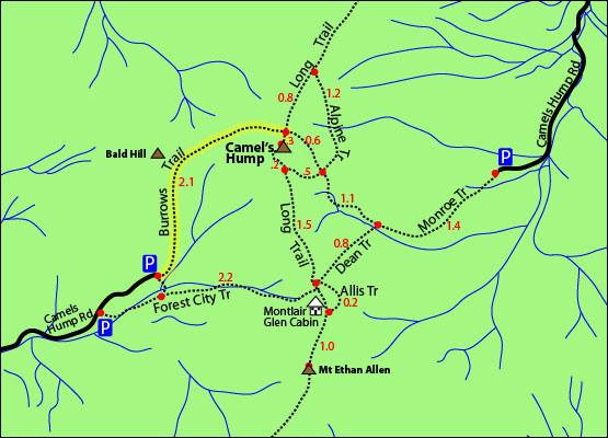 Click to download PDF Trail Map of Camel's Hump Click to download PDF Trail Map of Camel's Hump |
| |
|
| |
| Camel's Hump View Photos |
Top |
|
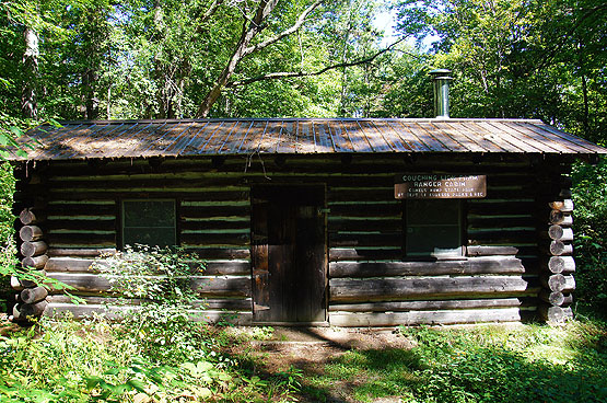
Ranger Cabin near the Monroe Traillhead parking lot on September 7, 2014.
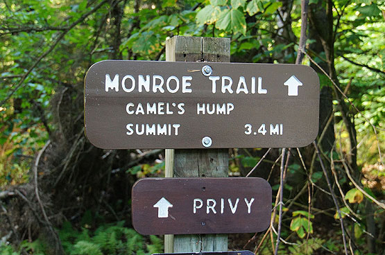
Start of the Monroe Trail to head up to Camel's Hump on September 7, 2014.
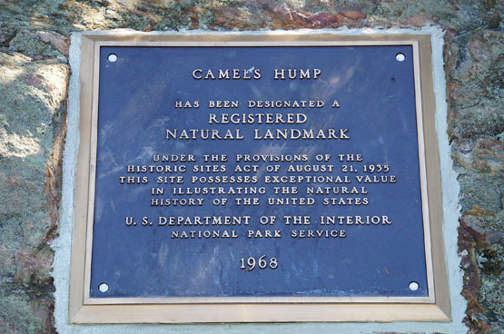
Camel's Hump has been designated a registered natural landmark. Photo taken on 9-7-2014.
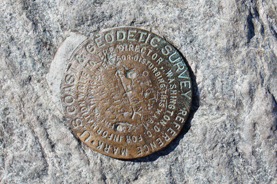
Survey marker on the summit of Camel's Hump on September 7, 2014.
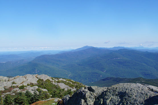
Looking towards Mount Mansfield in the distance from the summit of Camels Hump on 9-7-2014.
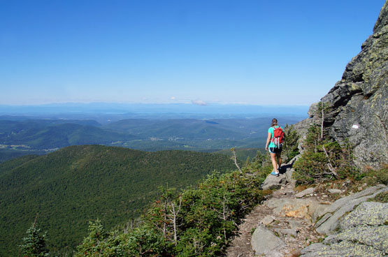
Heading up the Long Trail on Camel's Hump on September 7, 2014.
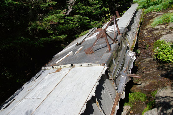
1944 Plane Crash site on the Alpine Trail on Camel's Hump. Photo taken on September 7, 2014.
|
| Camel's Hump Driving Directions |
Top |
The parking lot for the above hike is located on Camels Hump Road in Huntington, Vermont.
From I-89 North, take exit 10 for VT-100 South towards Waturbury/US-2.
Drive 0.3 miles and turn left onto VT-100 South.
Drive 0.5 miles and turn right onto US-2 W/N Main Street. Continue on US-2 West for 9.6 miles.
Turn left onto Cochran Road.
Drive 0.3 miles and turn left onto Wes White Hill.
Drive 3.1 miles and continue on Pond Road.
Drive 1.4 miles and continue on Bridge Street.
Drive 0.6 miles and turn left onto East Street.
Drive 276 feet and turn slight right onto Main Road.
Drive 2.5 miles and turn left onto Camels Hump Road.
Drive 0.6 miles and turn slight right to stay onto Camels Hump Road.
Drive to the end of the road, past the gate. If the gate is closed, you can park in the Winter lot before it.
To hike from the Monroe Trail, and you have a GPS, you can put in Camels Hump Road in Waterbury, Vermont. Once on that road, drive to the end.
|
|
On this page: Information | Trail maps | View Photos | Driving Directions | Top |
|
|
|
|
|
| |
|
|
|
|
|
|
| |
| New Hampshire 4,000 Footers |
Vermont + Maine 4,000 Footers |
Other Hiking Lists / Patches |
New England Mountain Ranges |
Stay Involved in New England |
New Hampshire
Mount Adams
Mount Bond
Bondcliff
Mount Bond, West Peak
Mount Cabot
Cannon Mountain
Mount Carrigain
Carter Dome
Carter, Middle
Carter, South
Mount Eisenhower
Mount Field
Mount Flume
Mount Galehead
Mount Garfield
Mount Hale
Mount Hancock
Mount Hancock, South Peak
Mount Isolation
Mount Jackson
Mount Jefferson
Mount Kinsman, North Peak
Mount Kinsman, South Peak
Mount Lafayette
Mount Liberty
Mount Lincoln
Mount Madison
Mount Monroe
Mount Moosilauke
Mount Moriah
Mount Osceola
Mount Osceola, East Peak
Owl's Head
Mount Passaconway
Mount Pierce
Mount Tecumseh
Mount Tom
Mount Tripyramid, Middle Peak
Mount Tripyramid, North Peak
Mount Twin, North Peak
Mount Twin, South Peak
Mount Washington
Mount Waumbek
Mount Whiteface
Mount Wildcat, A Peak
Mount Wildcat, D Peak
Mount Willey
Zealand Mountain |
Vermont
Mount Abraham
Camel's Hump
Mount Ellen
Killington Peak
Mount Mansfield
Maine
Mount Abraham
Mount Bigelow, Avery Peak
Mount Bigelow, West Peak
Crocker Mountain
Crocker Mountain, South
Mount Katahdin, Baxter Peak
Mount Katahdin, Hamlin Peak
North Brother Mountain
Old Speck Mountain
Mount Redington
Saddleback Mountain
Saddleback Mountain, The Horn
Spaulding Mountain
Sugarloaf Mountain |
NH 4,000 footers
NH 4,000 footers in Winter
New England 4,000 footers
NE 4,000 footers in Winter
NH Hundred Highest
New England Fifty Finest
52 With a view
Trailwrights 72 summit club
New England Hundred highest
NE Hundred highest in Winter
Northeast 111
48x12 "The Grid"
Red Lining
Belknap Range
LRCT / Castle in the Clouds
NH Fire Tower Quest
Hike by - Alphabetically
Hike by - Elevation
Hike by - Prominence
Hike by - Mountain Range |
Ranges in New Hampshire
View all NH mountain ranges
Baldface-Royce Range
Carter-Moriah Range
Dartmouth Range
Franconia Range
Kinsman Range
Mahoosuc
Range
Ossipee Mountains
Northern Ranges
Pemigewasset Wilderness
Pilot Range
Pliny Range
Presidential Range
Sandwich Range
Twin Range
Wapack Range
Western White Mountains
Willey Range
Ranges in Maine
View all ME mountain ranges
Baxter State Park
High Peaks
Bigelow Range
Eastern White Mountains
Ranges in Vermont
Green Mountains
Other VT mountain ranges |
NH Waterfalls
NH AMC Huts
Hiker's store |
New England 4,000 Footers | NH 4,000 Footers | VT 4,000 Footers | ME 4,000 Footers | Hiking Lists & Patches | Hiker's Store | Contact by email
© www.4000footers.com 2015. All rights reserved. We are not affiliated with the AMC or the AMC Four Thousand Footer Club |
|
|


