| View all NH 4,000 Footers |
| Mount Adams |
| Mount Bond |
| Bondcliff |
| Mount Bond, West Peak |
| Mount Cabot |
| Cannon Mountain |
| Mount Carrigain |
| Carter Dome |
| Carter, Middle |
| Carter, South |
| Mount Eisenhower |
| Mount Field |
| Mount Flume |
| Mount Galehead |
| Mount Garfield |
| Mount Hale |
| Mount Hancock |
| Mount Hancock, South Peak |
| Mount Isolation |
| Mount Jackson |
| Mount Jefferson |
| Mount Kinsman, North Peak |
| Mount Kinsman, South Peak |
| Mount Lafayette |
| Mount Liberty |
| Mount Lincoln |
| Mount Madison |
| Mount Monroe |
| Mount Moosilauke |
| Mount Moriah |
| Mount Osceola |
| Mount Osceola, East Peak |
| Owl's Head |
| Mount Passaconway |
| Mount Pierce |
| Mount Tecumseh |
| Mount Tom |
| Mount Tripyramid, Middle Peak |
| Mount Tripyramid, North Peak |
| Mount Twin, North Peak |
| Mount Twin, South Peak |
| Mount Washington |
| Mount Waumbek |
| Mount Whiteface |
| Mount Wildcat, A Peak |
| Mount Wildcat, D Peak |
| Mount Willey |
| Zealand Mountain |
| NH Mountain Ranges/ Areas ↓ |
| View all NH Mountain Ranges |
| Baldface-Royce Range |
| Carter-Moriah Range |
| Dartmouth Range |
| Franconia Range |
| Kinsman Range |
| Mahoosuc Range |
| Northern Ranges |
| Ossipee Mountains |
| Pemigewasset Wilderness |
| Pilot Range |
| Pliny Range |
| Presidential Range |
| Sandwich Range |
| Twin Range |
| Wapack Range |
| Willey Range |
|
|
Hike Mount Moosilauke |
| |
| On this page: Information | Trail maps | View Photos | Driving Directions |
| |
| Mount Moosilauke Information |
Elevation: 4,802 feet (1,464 meters)
Prominence:  2,933 feet (894 meters) 2,933 feet (894 meters)
Location: Benton, NH, Grafton County
Range: Kinsman Range
Coordinates: 44°01'24.57" North 71°49'52.71" West
Rating: Difficult
Features: Alpine Zone , Beaver Brook Waterfall, 360 Degree
Views, Appalachian Trail
Distance of highlighted hike below: 7.6 miles
|
 |
Mount Moosilauke is a 4,802 foot mountain located in Benton, New Hampshire along the Kinsman Range. It is the Western-most 4,000 footer mountain in the White Mountains. The Appalachian Trail passes over the mountain. The summit is above tree line and offers magnificent 360 degree views of the Franconia Ridge and the Kinsmans to the North, Jobildunc Ravine to the Southeast, and the Green Mountains of Vermont to the West. The name Moosilauke means literally bald place from Native American words moosi + auke.
| For peak-baggers: |
Mount Blue is 1 roughly 1 mile from the summit of Mount Moosilauke
South Peak is roughly 1 mile from the summit of Mount Moosilauke
Mount Jim is roughly 2.2 miles from the summit of Mount Moosilauke
|
|
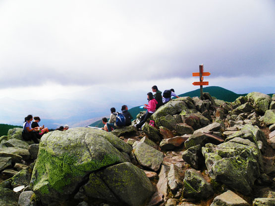
Summit of Mount Moosilauke on a very windy day. Photo taken on September 25, 2010. |
| |
| Mount Moosilauke Trail Maps - Directions from the parking lot to the summit |
Top |
| |
|
The map below shows how to get to the summit of Mount Moosilauke.
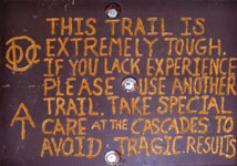
Begin at the Beaver Brook Trail Parking Lot/Kinsman Notch on Route 112. Hike up the Beaver Brook Trail for 1.5 miles. This is a very difficult hike, as signed, so only attempt if you have experience. The path can be very slippery around the falls and difficult to navigate around. Along most of this part of the trail is right next to the beautiful 1,000 foot Beaver Brook Cascades. After 1.5 miles you will reach Beaver Brook Shelter. From there, continue up 0.4 miles until you reach the junction with Asquam Ridge Trail. Stay left/straight to continue up the Beaver Brook Trail for another 1.5 miles until you reach the junction with the Benton Trail. Stay left/straight to continue on the same trail for the last 0.4 miles to the summit of Mount Moosilauke. Retrace your steps back down the same way to get to the parking lot. |
|
 |
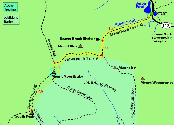
Click to download PDF Trail Map of Mount Moosilauke
|
| |
| |
| Mount Moosilauke Photos |
Top |
|
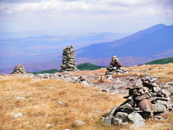
Cairns all along the filed near the summit of Mount Moosilauke on September 25, 2010.
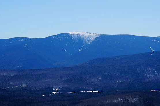
Mount Moosilauke as seen from the summit of Black Mountain in Benton, NH.
|
| Mount Moosilauke Driving Directions |
Top |
The parking lot for this hike is located on Route 112 in North Woodstock, NH. Take exit 32 off I-93. Turn onto 112 West and drive roughly 6 miles to the Beaver Brook Trail parking area. |
|
On this page: Information | Trail maps | View Photos | Driving Directions | Top
|
|
|
|
|
|
|
|
|
|
|
|
|
|
| |
| |
|
| New Hampshire 4,000 Footers |
Vermont + Maine 4,000 Footers |
Other Hiking Lists / Patches |
New England Mountain Ranges |
Stay Involved in New England |
New Hampshire
Mount Adams
Mount Bond
Bondcliff
Mount Bond, West Peak
Mount Cabot
Cannon Mountain
Mount Carrigain
Carter Dome
Carter, Middle
Carter, South
Mount Eisenhower
Mount Field
Mount Flume
Mount Galehead
Mount Garfield
Mount Hale
Mount Hancock
Mount Hancock, South Peak
Mount Isolation
Mount Jackson
Mount Jefferson
Mount Kinsman, North Peak
Mount Kinsman, South Peak
Mount Lafayette
Mount Liberty
Mount Lincoln
Mount Madison
Mount Monroe
Mount Moosilauke
Mount Moriah
Mount Osceola
Mount Osceola, East Peak
Owl's Head
Mount Passaconway
Mount Pierce
Mount Tecumseh
Mount Tom
Mount Tripyramid, Middle Peak
Mount Tripyramid, North Peak
Mount Twin, North Peak
Mount Twin, South Peak
Mount Washington
Mount Waumbek
Mount Whiteface
Mount Wildcat, A Peak
Mount Wildcat, D Peak
Mount Willey
Zealand Mountain |
Vermont
Mount Abraham
Camel's Hump
Mount Ellen
Killington Peak
Mount Mansfield
Maine
Mount Abraham
Mount Bigelow, Avery Peak
Mount Bigelow, West Peak
Crocker Mountain
Crocker Mountain, South
Mount Katahdin, Baxter Peak
Mount Katahdin, Hamlin Peak
North Brother Mountain
Old Speck Mountain
Mount Redington
Saddleback Mountain
Saddleback Mountain, The Horn
Spaulding Mountain
Sugarloaf Mountain |
NH 4,000 footers
NH 4,000 footers in Winter
New England 4,000 footers
NE 4,000 footers in Winter
NH Hundred Highest
New England Fifty Finest
52 With a view
Trailwrights 72 summit club
New England Hundred highest
NE Hundred highest in Winter
Northeast 111
48x12 "The Grid"
Red Lining
Belknap Range
LRCT / Castle in the Clouds
NH Fire Tower Quest
Hike by - Alphabetically
Hike by - Elevation
Hike by - Prominence
Hike by - Mountain Range |
Ranges in New Hampshire
View all NH mountain ranges
Baldface-Royce Range
Carter-Moriah Range
Dartmouth Range
Franconia Range
Kinsman Range
Mahoosuc
Range
Ossipee Mountains
Northern Ranges
Pemigewasset Wilderness
Pilot Range
Pliny Range
Presidential Range
Sandwich Range
Twin Range
Wapack Range
Western White Mountains
Willey Range
Ranges in Maine
View all ME mountain ranges
Baxter State Park
High Peaks
Bigelow Range
Eastern White Mountains
Ranges in Vermont
Green Mountains
Other VT mountain ranges |
NH Waterfalls
NH AMC Huts
Hiker's store |
New England 4,000 Footers | NH 4,000 Footers | VT 4,000 Footers | ME 4,000 Footers | Hiking Lists & Patches | Hiker's Store | Contact by email
© www.4000footers.com 2015. All rights reserved. We are not affiliated with the AMC or the AMC Four Thousand Footer Club |
|
|


