| View all NH 4,000 Footers |
| Mount Adams |
| Mount Bond |
| Bondcliff |
| Mount Bond, West Peak |
| Mount Cabot |
| Cannon Mountain |
| Mount Carrigain |
| Carter Dome |
| Carter, Middle |
| Carter, South |
| Mount Eisenhower |
| Mount Field |
| Mount Flume |
| Mount Galehead |
| Mount Garfield |
| Mount Hale |
| Mount Hancock |
| Mount Hancock, South Peak |
| Mount Isolation |
| Mount Jackson |
| Mount Jefferson |
| Mount Kinsman, North Peak |
| Mount Kinsman, South Peak |
| Mount Lafayette |
| Mount Liberty |
| Mount Lincoln |
| Mount Madison |
| Mount Monroe |
| Mount Moosilauke |
| Mount Moriah |
| Mount Osceola |
| Mount Osceola, East Peak |
| Owl's Head |
| Mount Passaconway |
| Mount Pierce |
| Mount Tecumseh |
| Mount Tom |
| Mount Tripyramid, Middle Peak |
| Mount Tripyramid, North Peak |
| Mount Twin, North Peak |
| Mount Twin, South Peak |
| Mount Washington |
| Mount Waumbek |
| Mount Whiteface |
| Mount Wildcat, A Peak |
| Mount Wildcat, D Peak |
| Mount Willey |
| Zealand Mountain |
| NH Mountain Ranges/ Areas ↓ |
| View all NH Mountain Ranges |
| Baldface-Royce Range |
| Carter-Moriah Range |
| Dartmouth Range |
| Franconia Range |
| Kinsman Range |
| Mahoosuc Range |
| Northern Ranges |
| Ossipee Mountains |
| Pemigewasset Wilderness |
| Pilot Range |
| Pliny Range |
| Presidential Range |
| Sandwich Range |
| Twin Range |
| Wapack Range |
| Willey Range |
|
|
Hike North Tripyramid Mountain |
| |
| On this page: Information | Trail maps | View Photos | Driving Directions |
| |
| North Tripyramid Mountain Information |
Elevation: 4,180 feet (1,270 meters)
Prominence:  1,320 feet (400 meters) 1,320 feet (400 meters)
Location: Waterville Valley, NH (Grafton County, USA)
Range: Sandwich Range
Coordinates: 43°58.40' North 71°26.57' West
Rating: Moderate with some difficult parts
Features: Sabbaday Falls, Sandwich Wilderness Area, Brooks, Cascades, Peak Bagging
Distance of highlighted hike below: 11 miles with Middle
Tripyramid Mountain
|
 |
North Tripyramid Mountain is a 4,180 foot mountain in the Sandwich Range of the White Mountains in Waterville Valley. Scaur Peak and The Fool Killer are other peaks to the Northwest and Northeast of the mountain. South Tripyramid Mountain is Southwest of North Tripyramid Mountain, though well over 4,000 feet, it is not considered an official New Hampshire 4,000 footer because of its low prominence (under 200 feet is too low). Middle Tripyramid Mountain is roughly 0.7 miles away, so one can hike both Tripyramid Mountains in one day by peak bagging.
|
| North Tripyramid Mountain Trail Maps - Directions from the parking lot to the summit |
Top |
The map below shows how to get to the summit of North Tripyramid Mountain as well as Middle Tripyramid Mountain.
There are 2 trails you can choose to start and end at: Pine Bend Brook Trail and Sabbaday Brook Trail. Both begin on Route 112. (Sabbaday Falls parking lot has plenty of parking spaces, unlike the Pine Bend Brook parking area where you just park on the side of Route 112.) These directions are starting from Pine Bend Brook Trail:
Hike for 3.2 miles on the Pine Bend Brook Trail until you come to a junction with the Scaur Ridge Trail. Stay straight to continue along the Pine Bend Brook Trail for another 0.8 miles until you reach the summit of North Tripyramid Mountain. (This mountain does not have very good views as this area is not above tree line. There is also no summit sign, so you might go right past it and not even know it.) From the summit, continue for 0.7 miles passing a junction of Sabbaday Brook Trail after 0.5 miles until you are on the summit of Middle Tripyramid Mountain. (Again, there is no sign indicating you are on the summit, but there is a nice bare rock to sit or stand on with great views. To start your descent down, you will retrace your steps back for 0.3 miles until you are back at the Sabbaday Brook Trail junction. Take that right for 4.6 miles (you will cross the Sabbaday Brook several times closer to the end) until you reach the stunning Sabbaday Falls. After you have stopped to look at the falls, continue down the Sabbaday Brook Trail for another 0.3 miles until you reach the parking area. From there, turn left onto Route 112 and walk for 1 mile until you reach the area you parked.
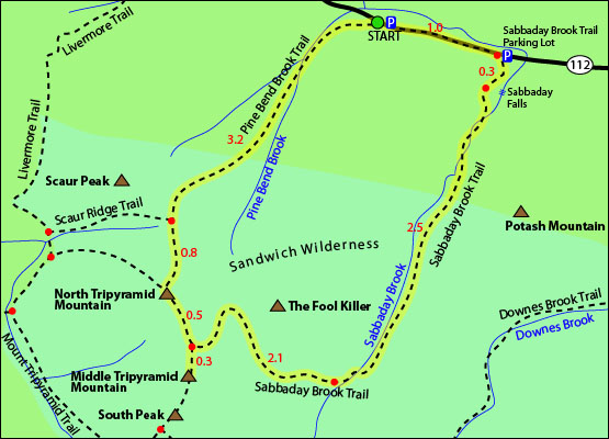
Click to download PDF Trail Map of Middle Tripyramid Mountain
|
| |
|
| |
| North Tripyramid Mountain Photos |
Top |
|
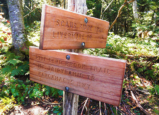
Photo taken near the summit of North Tripyramid Mountain on September 4, 2010.
|
| North Tripyramid Mountain Driving Directions |
Top |
The 2 parking areas for this hike are located on Route 112 in Waterville Valley, New Hampshire.
Sabbaday Brook Trail Parking Area:
If you are coming from the West, the parking area is located about 20 miles East of the junction I-93 and Route 112/Kancamagus Highway, on the right hand side.
If you are coming from the East, the parking area is located about 15.5 miles West of the junction I-93 and Route 112/Kancamagus Highway, on the left hand side.
Pine Bend Brook Trail Parking Area:
If you are coming from the West, the parking area is located about 19 miles East of the junction I-93 and Route 112/Kancamagus Highway, on the right hand side.
If you are coming from the East, the parking areas is located about 16.5 miles West of the junction I-93 and Route 112/Kancamagus Highway, on the left hand side.
**Note**
The Pine Bend Brook Trail parking area is just street parking. Look for a small brown sign indicating a trail head starts, and park as close to it as you can along Route 112/Kancamagus Highway. |
|
On this page: Information | Trail maps | View Photos | Driving Directions | Top
|
|
|
|
|
|
|
|
| |
|
|
|
|
| |
| |
|
| New Hampshire 4,000 Footers |
Vermont + Maine 4,000 Footers |
Other Hiking Lists / Patches |
New England Mountain Ranges |
Stay Involved in New England |
New Hampshire
Mount Adams
Mount Bond
Bondcliff
Mount Bond, West Peak
Mount Cabot
Cannon Mountain
Mount Carrigain
Carter Dome
Carter, Middle
Carter, South
Mount Eisenhower
Mount Field
Mount Flume
Mount Galehead
Mount Garfield
Mount Hale
Mount Hancock
Mount Hancock, South Peak
Mount Isolation
Mount Jackson
Mount Jefferson
Mount Kinsman, North Peak
Mount Kinsman, South Peak
Mount Lafayette
Mount Liberty
Mount Lincoln
Mount Madison
Mount Monroe
Mount Moosilauke
Mount Moriah
Mount Osceola
Mount Osceola, East Peak
Owl's Head
Mount Passaconway
Mount Pierce
Mount Tecumseh
Mount Tom
Mount Tripyramid, Middle Peak
Mount Tripyramid, North Peak
Mount Twin, North Peak
Mount Twin, South Peak
Mount Washington
Mount Waumbek
Mount Whiteface
Mount Wildcat, A Peak
Mount Wildcat, D Peak
Mount Willey
Zealand Mountain |
Vermont
Mount Abraham
Camel's Hump
Mount Ellen
Killington Peak
Mount Mansfield
Maine
Mount Abraham
Mount Bigelow, Avery Peak
Mount Bigelow, West Peak
Crocker Mountain
Crocker Mountain, South
Mount Katahdin, Baxter Peak
Mount Katahdin, Hamlin Peak
North Brother Mountain
Old Speck Mountain
Mount Redington
Saddleback Mountain
Saddleback Mountain, The Horn
Spaulding Mountain
Sugarloaf Mountain |
NH 4,000 footers
NH 4,000 footers in Winter
New England 4,000 footers
NE 4,000 footers in Winter
NH Hundred Highest
New England Fifty Finest
52 With a view
Trailwrights 72 summit club
New England Hundred highest
NE Hundred highest in Winter
Northeast 111
48x12 "The Grid"
Red Lining
Belknap Range
LRCT / Castle in the Clouds
NH Fire Tower Quest
Hike by - Alphabetically
Hike by - Elevation
Hike by - Prominence
Hike by - Mountain Range |
Ranges in New Hampshire
View all NH mountain ranges
Baldface-Royce Range
Carter-Moriah Range
Dartmouth Range
Franconia Range
Kinsman Range
Mahoosuc
Range
Ossipee Mountains
Northern Ranges
Pemigewasset Wilderness
Pilot Range
Pliny Range
Presidential Range
Sandwich Range
Twin Range
Wapack Range
Western White Mountains
Willey Range
Ranges in Maine
View all ME mountain ranges
Baxter State Park
High Peaks
Bigelow Range
Eastern White Mountains
Ranges in Vermont
Green Mountains
Other VT mountain ranges |
NH Waterfalls
NH AMC Huts
Hiker's store |
New England 4,000 Footers | NH 4,000 Footers | VT 4,000 Footers | ME 4,000 Footers | Hiking Lists & Patches | Hiker's Store | Contact by email
© www.4000footers.com 2015. All rights reserved. We are not affiliated with the AMC or the AMC Four Thousand Footer Club |
|
|


