|
|
|
Hike Mount Ellen |
| |
| On this page: Information | Trail maps | View Photos | Driving Directions |
| |
Elevation: 4,083 feet (1,244 meters)
Prominence:  2132 feet (650 meters) 2132 feet (650 meters)
Location: Warren, VT (Washington County)
Range: Green Mountains
Coordinates: 44°9.59' North 72°55.73' West
Rating: Moderate
Features: Long Trail, Peak bag, Glen Ellen cabin close-by, no river crossings, plane crash site
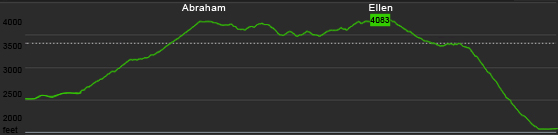
Distance of highlighted hike below: 10.8 miles with Mount Abraham, or 8.2 miles alone.
|
 |
Mount Ellen is a 4,083 foot mountain in the Green Mountains of Vermont. The Long Trail traverses the summit ridge of Mount Abraham. The mountain is situated between Cutts Peak to the South and Gen. Stark Mountain to the North.
Mount Ellen as well as Lincoln Peak provide the slopes for Sugarbush Ski Resort in Mad River Valley.
There is no views on the actual summit of Mount Ellen, but just a few feet North on the Long Trail there are views from the top of the ski lift.
| There was a plane crash on Mount Abraham (between Mount Ellen and Abraham) |
On June 28, 1973, a pilot on his way from Twin Mountain, Vermont to Newburgh, New York was trying to navigate through a thick cloud and struck some trees at roughly 3,000 feet elevation on Mount Abraham. He survived the plane crash, but parts of the place still exist on the mountain today.
Plane info: Cessna 182N Registration Number N92431. To find this plane and other plane crash sites in New England visit our Plane Crashes page. There is a map below with the plane crash site pointed out just after the summit of Mount Abraham to the North. |
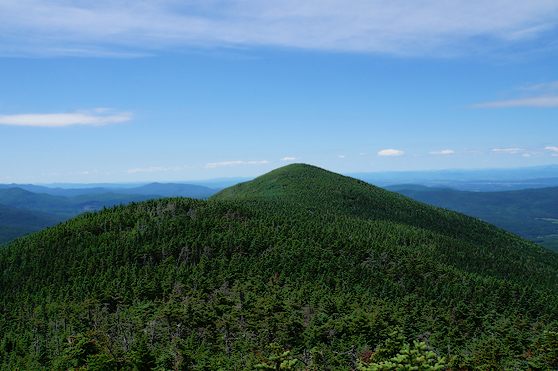
Looking at Cutts Peak and Mount Ellen right behind it on July 5, 2014.
| For peak-baggers: |
Cutts Peak is roughly 0.5 miles from the summit of Mount Ellen
Nancy Hanks Peak is 1.6 miles from the summit of Mount Ellen
Gen. Stark Mountain is 2.2 miles from the summit of Mount Ellen
Lincoln Peak is 2.9 miles from the summit of Mount Ellen
Mount Abraham is 3.7 miles from the summit of Mount Ellen
|
|
| Mount Ellen Trail Maps - Directions from the parking lot to the summit |
Top |
The map below shows how to get to the summit of Mount Ellen as well as Mount Abraham from a traverse of the Jim Dwire Road parking lot and the Lincoln Gap parking lot.
NOTE: This hike requires a car spot. (Hiking in from one parking lot, and ending in another, requiring a car at each parking lot.)
You can begin at either parking lot, but this site will give directions starting from the Dwire Road parking lot. Hike up the Jerusalem Trail for 2.4 miles until you come to a junction with the Long Trail. Turn right onto the Long Trail. Hike for 1.8 miles and you will reach the summit of Mount Ellen. From here you can choose to hike back down the way you came, or continue hiking to peak bag Ellen with Mount Abraham.
Continue straight along the Long Trail for roughly 0.5 miles where you will reach the summit of Cutts Peak at 4,022 feet. Hike another 1.1 miles and you reach the summit of Nancy Hanks Peak at 3,812 feet. From here hike another 1.3 miles where you will find yourself on the summit of Lincoln Peak. After enjoying the views, continue for 0.8 miles on the Long Trail and you will reach the summit of Mount Abraham. When you are ready to start heading down to the road, continue over Mount Abraham's summit on the Long Trail for another 2.6 miles where you will reach the Lincoln Gap Parking Lot. (You will come to a junction after 0.9 miles, but you will just continue straight through it to proceed on the Long Trail.)
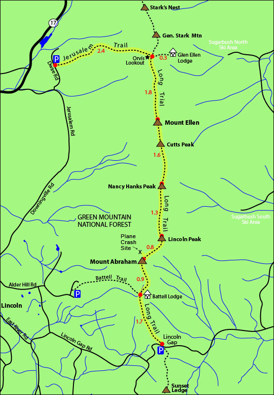
Click to download PDF Trail Map of Mount Ellen
|
| |
| |
| Mount Ellen View Photos |
Top |
|
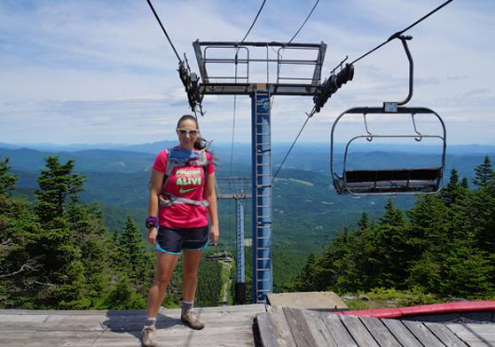
Views right after the summit of Mount Ellen heading North on July 5, 2014.
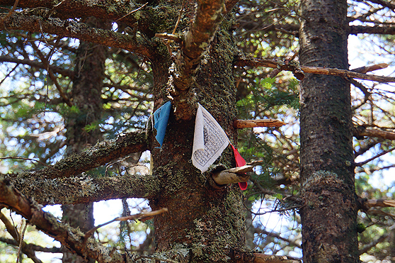
Arrow showing to continue on the Long Trail, follow the arrow. Many people make the mistake of heading down the ski slopes. July 5, 2014.
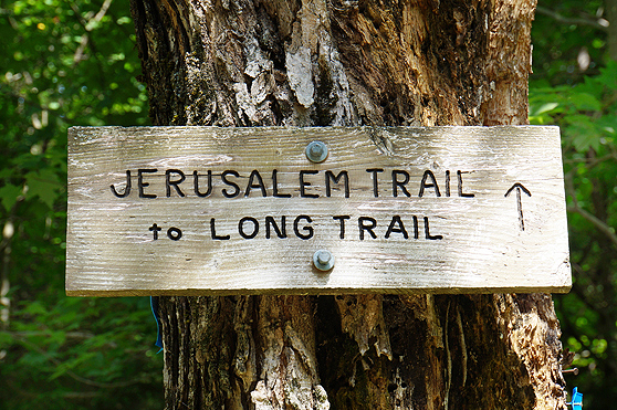
Sign on Dwire Road at the start of the Jerusalem Trail on July 5, 2014.
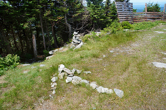
The viewless summit of Mount Ellen on July 5, 2014.
|
| Mount Ellen Driving Directions |
Top |
There are 2 parking lots for the hike mentioned above. You can begin at either parking lot, and end at the other.
To get to the Jerusalem Trail on Jim Dwire Road:
From I-89 North, take exit 9 towards US-2/Middlesex/Moretown/VT-100. Drive 0.2 miles and turn left onto Center Road. Drive 0.1 miles and turn left onto US-2 East. Drive 0.6 miles and turn right onto Vermont 100B South. Drive 7.9 miles and continue straight on VT-100 S/Main Street. Continue to follow VT-100 South for 5.4 miles and take a slight right onto VT-17 West. Drive 12.2 miles and turn left onto Jerusalem Road. Drive 0.7 miles and turn left onto Jim Dwire Road. The parking lot will be roughly a half mile on the right side of the road.
To get to the Lincoln Gap Road parking lot from the Jim Dwire Road parking lot:
From Jim Dwire Road, turn left onto Jerusalem Road. Drive 0.8 miles and continue on Downingville Road. Drive 3.6 miles and turn left onto Quaker Street. Drive 0.9 miles and take the third left onto E River Road. Drive 1.1 miles and continue onto Lincoln Gap Road. Drive roughly 3.5 miles to the Lincoln Gap parking lot which will be on the right side of the road.
|
|
On this page: Information | Trail maps | View Photos | Driving Directions | Top |
|
|
|
|
|
| |
|
|
|
|
|
|
|
|
|
|
|
| |
| New Hampshire 4,000 Footers |
Vermont + Maine 4,000 Footers |
Other Hiking Lists / Patches |
New England Mountain Ranges |
Stay Involved in New England |
New Hampshire
Mount Adams
Mount Bond
Bondcliff
Mount Bond, West Peak
Mount Cabot
Cannon Mountain
Mount Carrigain
Carter Dome
Carter, Middle
Carter, South
Mount Eisenhower
Mount Field
Mount Flume
Mount Galehead
Mount Garfield
Mount Hale
Mount Hancock
Mount Hancock, South Peak
Mount Isolation
Mount Jackson
Mount Jefferson
Mount Kinsman, North Peak
Mount Kinsman, South Peak
Mount Lafayette
Mount Liberty
Mount Lincoln
Mount Madison
Mount Monroe
Mount Moosilauke
Mount Moriah
Mount Osceola
Mount Osceola, East Peak
Owl's Head
Mount Passaconway
Mount Pierce
Mount Tecumseh
Mount Tom
Mount Tripyramid, Middle Peak
Mount Tripyramid, North Peak
Mount Twin, North Peak
Mount Twin, South Peak
Mount Washington
Mount Waumbek
Mount Whiteface
Mount Wildcat, A Peak
Mount Wildcat, D Peak
Mount Willey
Zealand Mountain |
Vermont
Mount Abraham
Camel's Hump
Mount Ellen
Killington Peak
Mount Mansfield
Maine
Mount Abraham
Mount Bigelow, Avery Peak
Mount Bigelow, West Peak
Crocker Mountain
Crocker Mountain, South
Mount Katahdin, Baxter Peak
Mount Katahdin, Hamlin Peak
North Brother Mountain
Old Speck Mountain
Mount Redington
Saddleback Mountain
Saddleback Mountain, The Horn
Spaulding Mountain
Sugarloaf Mountain |
NH 4,000 footers
NH 4,000 footers in Winter
New England 4,000 footers
NE 4,000 footers in Winter
NH Hundred Highest
New England Fifty Finest
52 With a view
Trailwrights 72 summit club
New England Hundred highest
NE Hundred highest in Winter
Northeast 111
48x12 "The Grid"
Red Lining
Belknap Range
LRCT / Castle in the Clouds
NH Fire Tower Quest
Hike by - Alphabetically
Hike by - Elevation
Hike by - Prominence
Hike by - Mountain Range |
Ranges in New Hampshire
View all NH mountain ranges
Baldface-Royce Range
Carter-Moriah Range
Dartmouth Range
Franconia Range
Kinsman Range
Mahoosuc
Range
Ossipee Mountains
Northern Ranges
Pemigewasset Wilderness
Pilot Range
Pliny Range
Presidential Range
Sandwich Range
Twin Range
Wapack Range
Western White Mountains
Willey Range
Ranges in Maine
View all ME mountain ranges
Baxter State Park
High Peaks
Bigelow Range
Eastern White Mountains
Ranges in Vermont
Green Mountains
Other VT mountain ranges |
NH Waterfalls
NH AMC Huts
Hiker's store |
New England 4,000 Footers | NH 4,000 Footers | VT 4,000 Footers | ME 4,000 Footers | Hiking Lists & Patches | Hiker's Store | Contact by email
© www.4000footers.com 2015. All rights reserved. We are not affiliated with the AMC or the AMC Four Thousand Footer Club |
|
|


