| View all NH 4,000 Footers |
| Mount Adams |
| Mount Bond |
| Bondcliff |
| Mount Bond, West Peak |
| Mount Cabot |
| Cannon Mountain |
| Mount Carrigain |
| Carter Dome |
| Carter, Middle |
| Carter, South |
| Mount Eisenhower |
| Mount Field |
| Mount Flume |
| Mount Galehead |
| Mount Garfield |
| Mount Hale |
| Mount Hancock |
| Mount Hancock, South Peak |
| Mount Isolation |
| Mount Jackson |
| Mount Jefferson |
| Mount Kinsman, North Peak |
| Mount Kinsman, South Peak |
| Mount Lafayette |
| Mount Liberty |
| Mount Lincoln |
| Mount Madison |
| Mount Monroe |
| Mount Moosilauke |
| Mount Moriah |
| Mount Osceola |
| Mount Osceola, East Peak |
| Owl's Head |
| Mount Passaconway |
| Mount Pierce |
| Mount Tecumseh |
| Mount Tom |
| Mount Tripyramid, Middle Peak |
| Mount Tripyramid, North Peak |
| Mount Twin, North Peak |
| Mount Twin, South Peak |
| Mount Washington |
| Mount Waumbek |
| Mount Whiteface |
| Mount Wildcat, A Peak |
| Mount Wildcat, D Peak |
| Mount Willey |
| Zealand Mountain |
| NH Mountain Ranges/ Areas ↓ |
| View all NH Mountain Ranges |
| Baldface-Royce Range |
| Carter-Moriah Range |
| Dartmouth Range |
| Franconia Range |
| Kinsman Range |
| Mahoosuc Range |
| Northern Ranges |
| Ossipee Mountains |
| Pemigewasset Wilderness |
| Pilot Range |
| Pliny Range |
| Presidential Range |
| Sandwich Range |
| Twin Range |
| Wapack Range |
| Willey Range |
|
|
Hike Mount Jefferson |
| |
| On this page: Information | Trail maps | View Photos | Driving Directions |
| |
| Mount Jefferson Information |
Elevation: 5,712 feet (1,741 meters)
Prominence:  742 feet (226.2 meters) 742 feet (226.2 meters)
Location: Thompson and Meserves Purchase, NH (Coös County, New Hampshire, USA)
Range: Presidential Range
Coordinates: 44°18'15" North 71°19'01" West
Rating: Difficult
Features: Cascades, Rock Scrambles , Alpine Zone , 360 Degree Views, Peak Bagging
Distance of highlighted hike below: 5 miles
|
 |
Mount Jefferson is a 5,712 foot mountain in the Presidential Range of the White Mountains. It is the third tallest mountain in New Hampshire. The mountain is named after the third President of the United States, Thomas Jefferson. Mount Jefferson sits between Mount Clay (to the South) and Mount Adams (another 4,000 footer, to the North).
Besides the summit of Mount Jefferson having amazing 360 degree views including Mount Washington to the South, it also has several other features, making it a popular hike. There are 2 ridges that lead up to the summit: Ridge of the Caps and Castle Ridge, both offering spectacular views less than a mile into your hike. Mount Jefferson is also surrounded by 3 dramatic glacial cirques of Jefferson Ravine, Castle Ravine and the Great Gulf. There is a large area of alpine grass near the summit called The Monticello Lawn, which is special because this area, near any summit, would normally be covered by talus. When viewed from the South, Jefferson features an arrow-shaped bald patch pointing to its summit
If you want to get an incredible view from a New Hampshire 4,000 footer in one of the shortest hikes (on the 4,000 footer list) to one of the tallest mountains, Mount Jefferson is the one to hike. In just 2.5 miles you can be at the summit via the Caps Ridge Trail. Though short, it is also a difficult hike including lots of rock scrambles and can be very challenging at times. This route only gains 2,700 feet (830 meters) vertically to the summit, making it one of the quickest ascents up any Presidential Range mountain. Another popular hike up to the summit, though longer, is by taking the Jefferson Loop Trail.
| For peak-baggers |
Mount Clay is 1.6 miles from the summit of Mount Jefferson
Mount Adams is 2.3 miles from the summit of Mount Jefferson
Mount Madison is 3.3 miles from the summit of Mount Jefferson
|
|
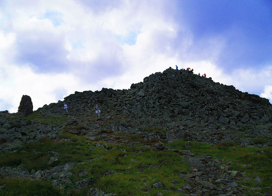
Looking up to the summit of Mount Jefferson from the East side on August 14, 2010. |
| |
| Mount Jefferson Trail Maps - Directions from the parking lot to the summit |
Top |
The map below shows how to get to the summit of Mount Jefferson via the highlighted trail. You can also peak bag Mount Jefferson with Mount Clay and/or Mount Adams via other trails shown below.
Begin on the Caps Ridge Trail on Jefferson Notch Road. Hike up for 2.1 miles until you reach the intersection of The Cornice. Here you will want to stay straight, continuing along the Caps Ridge Trail for another 0.4 miles to the summit of Mount Jefferson. The first half of the hike is fairly easy on dirt/rocky ground, while the second half is much more difficult, including rock scrambles and difficult terrain.
If you choose to hike over to Mount Clay from Jefferson's summit, it is another 1.5 miles via the Gulfside Trail. Mount Washington is another 1.7 miles from Mount Clay via the Caly Loop Trail, then the roughly half a mile on the Great Gulf Trail.
If you choose to hike over to Mount Adams from Jefferson's summit, it is another 2.5 miles via the Gulfside Trail. From Mount Adams, you can reach Mount Madison in 1.4 miles via the Gulfside Trail.
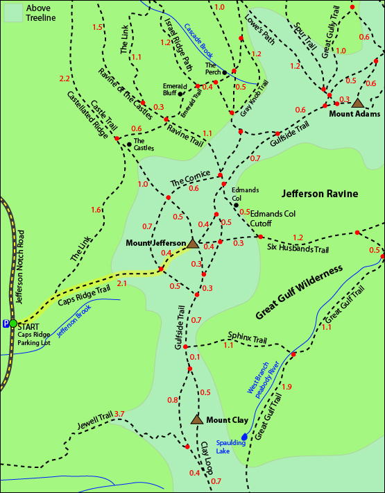
Click to download PDF Trail Map of Mount Jefferson
|
| |
|
| |
| Mount Jefferson Photos |
Top |
|
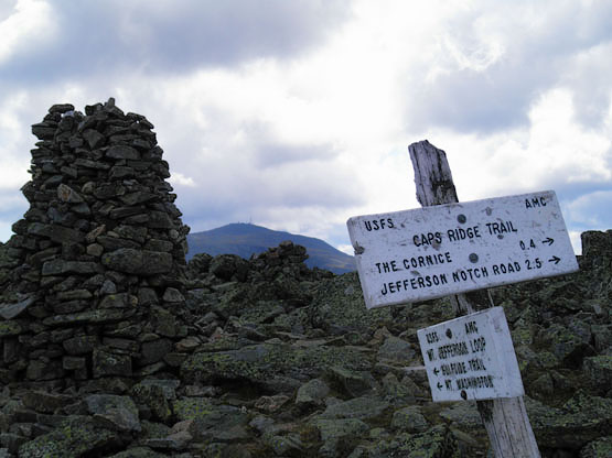
Cairn near the summit of Mount Jefferson on August 14, 2010. Mount Washington in the background.
|
| Mount Jefferson Driving Directions |
Top |
The parking lot for the highlighted hike above is at the Caps Ridge Trail head, located on Jefferson Notch Road in Thompson and Meserves Purchase, New Hampshire.
If you are traveling West on Route 302
Heading West on Route 302, turn Right on Mount Clinton Road (0.2 miles past the AMC Highland Center). Travel 3.6 miles then at a crossroads, go straight onto Jefferson Notch Road and follow for 3.4 miles down the dirt road. The parking area will be on the right hand side of the road.
If you are traveling East on Route 302
Traveling East on Route 302, turn left onto Base Station Road, which is the road that leads to the Cog Railroad). The turn is 4.4 miles East of the junction of Route 3 and 302. Continue 4.5 miles, then at the crossroads, turn left onto Jefferson Notch Road, and follow for 3.4 miles on the dirt road. The parking area will be on the right hand side of the road.
If you are traveling from Route 2 in Randolph
Turn South onto Valley Road, which is 3.3 miles East of the junction of Routes 2 and 115. After 1.2 miles, turn left onto Jefferson Notch Road and follow for 5.3 miles. The parking area will be on the left hand side of the road. |
|
On this page: Information | Trail maps | View Photos | Driving Directions | Top
|
|
|
|
|
|
|
|
|
|
|
|
|
| |
| |
| |
|
| New Hampshire 4,000 Footers |
Vermont + Maine 4,000 Footers |
Other Hiking Lists / Patches |
New England Mountain Ranges |
Stay Involved in New England |
New Hampshire
Mount Adams
Mount Bond
Bondcliff
Mount Bond, West Peak
Mount Cabot
Cannon Mountain
Mount Carrigain
Carter Dome
Carter, Middle
Carter, South
Mount Eisenhower
Mount Field
Mount Flume
Mount Galehead
Mount Garfield
Mount Hale
Mount Hancock
Mount Hancock, South Peak
Mount Isolation
Mount Jackson
Mount Jefferson
Mount Kinsman, North Peak
Mount Kinsman, South Peak
Mount Lafayette
Mount Liberty
Mount Lincoln
Mount Madison
Mount Monroe
Mount Moosilauke
Mount Moriah
Mount Osceola
Mount Osceola, East Peak
Owl's Head
Mount Passaconway
Mount Pierce
Mount Tecumseh
Mount Tom
Mount Tripyramid, Middle Peak
Mount Tripyramid, North Peak
Mount Twin, North Peak
Mount Twin, South Peak
Mount Washington
Mount Waumbek
Mount Whiteface
Mount Wildcat, A Peak
Mount Wildcat, D Peak
Mount Willey
Zealand Mountain |
Vermont
Mount Abraham
Camel's Hump
Mount Ellen
Killington Peak
Mount Mansfield
Maine
Mount Abraham
Mount Bigelow, Avery Peak
Mount Bigelow, West Peak
Crocker Mountain
Crocker Mountain, South
Mount Katahdin, Baxter Peak
Mount Katahdin, Hamlin Peak
North Brother Mountain
Old Speck Mountain
Mount Redington
Saddleback Mountain
Saddleback Mountain, The Horn
Spaulding Mountain
Sugarloaf Mountain |
NH 4,000 footers
NH 4,000 footers in Winter
New England 4,000 footers
NE 4,000 footers in Winter
NH Hundred Highest
New England Fifty Finest
52 With a view
Trailwrights 72 summit club
New England Hundred highest
NE Hundred highest in Winter
Northeast 111
48x12 "The Grid"
Red Lining
Belknap Range
LRCT / Castle in the Clouds
NH Fire Tower Quest
Hike by - Alphabetically
Hike by - Elevation
Hike by - Prominence
Hike by - Mountain Range |
Ranges in New Hampshire
View all NH mountain ranges
Baldface-Royce Range
Carter-Moriah Range
Dartmouth Range
Franconia Range
Kinsman Range
Mahoosuc
Range
Ossipee Mountains
Northern Ranges
Pemigewasset Wilderness
Pilot Range
Pliny Range
Presidential Range
Sandwich Range
Twin Range
Wapack Range
Western White Mountains
Willey Range
Ranges in Maine
View all ME mountain ranges
Baxter State Park
High Peaks
Bigelow Range
Eastern White Mountains
Ranges in Vermont
Green Mountains
Other VT mountain ranges |
NH Waterfalls
NH AMC Huts
Hiker's store |
New England 4,000 Footers | NH 4,000 Footers | VT 4,000 Footers | ME 4,000 Footers | Hiking Lists & Patches | Hiker's Store | Contact by email
© www.4000footers.com 2015. All rights reserved. We are not affiliated with the AMC or the AMC Four Thousand Footer Club |
|
|


