| View all NH 4,000 Footers |
| Mount Adams |
| Mount Bond |
| Bondcliff |
| Mount Bond, West Peak |
| Mount Cabot |
| Cannon Mountain |
| Mount Carrigain |
| Carter Dome |
| Carter, Middle |
| Carter, South |
| Mount Eisenhower |
| Mount Field |
| Mount Flume |
| Mount Galehead |
| Mount Garfield |
| Mount Hale |
| Mount Hancock |
| Mount Hancock, South Peak |
| Mount Isolation |
| Mount Jackson |
| Mount Jefferson |
| Mount Kinsman, North Peak |
| Mount Kinsman, South Peak |
| Mount Lafayette |
| Mount Liberty |
| Mount Lincoln |
| Mount Madison |
| Mount Monroe |
| Mount Moosilauke |
| Mount Moriah |
| Mount Osceola |
| Mount Osceola, East Peak |
| Owl's Head |
| Mount Passaconway |
| Mount Pierce |
| Mount Tecumseh |
| Mount Tom |
| Mount Tripyramid, Middle Peak |
| Mount Tripyramid, North Peak |
| Mount Twin, North Peak |
| Mount Twin, South Peak |
| Mount Washington |
| Mount Waumbek |
| Mount Whiteface |
| Mount Wildcat, A Peak |
| Mount Wildcat, D Peak |
| Mount Willey |
| Zealand Mountain |
| NH Mountain Ranges/ Areas ↓ |
| View all NH Mountain Ranges |
| Baldface-Royce Range |
| Carter-Moriah Range |
| Dartmouth Range |
| Franconia Range |
| Kinsman Range |
| Mahoosuc Range |
| Northern Ranges |
| Ossipee Mountains |
| Pemigewasset Wilderness |
| Pilot Range |
| Pliny Range |
| Presidential Range |
| Sandwich Range |
| Twin Range |
| Wapack Range |
| Willey Range |
|
|
Hike South Twin Mountain |
| |
| On this page: Information | Trail maps | View Photos | Driving Directions |
| |
| South Twin Mountain Information |
Elevation: 4,902 feet (1,494 meters)
Prominence:  1,522 feet (464 meters) 1,522 feet (464 meters)
Location: Grafton County, New Hampshire, USA
Range: Twin Range
Coordinates: 44°11.25' North 71°33.32' West
Rating: Moderate
Features: Little River, Peak Bagging
Distance of highlighted hike below: 11 miles with North Twin Mountain
|
 |
South Twin Mountain is a 4,902 foot mountain in the Twin Range in New Hampshire (Grafton County) in the White Mountains. The summit of South Twin Mountain is rocky, but open. On a clear day, you have great views even though there are many spruce and fir trees surrounding.
There are several trails one can take to get the the summit of South Twin Mountain. To peak bag it easily with North Twin Mountain, you would want to take the North Twin Trail beginning at the end of Haystack Road. This is an 11 mile round-trip hike. See map below.
| For peak-baggers: |
Galehead Hut is 0.9 miles from the summit of North Twin Mountain
North Twin Mountain is 1.3 miles from the summit of North Twin Mountain
Galehead Mountain is 1.4 miles from the summit of North Twin Mountain
Mount Guyot is 2.4 miles from the summit of North Twin Mountain
West Bond is 3.4 miles from the summit of North Twin Mountain
Mount Bond is 3.4 miles from the summit of North Twin Mountain
|
|
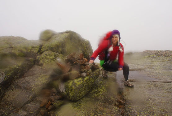
Summit cairn on South Twin Mountain on October 11, 2012 - a VERY windy, rainy, wet day! |
| |
| South Twin Mountain Trail Maps - Directions from the parking lot to the summit |
Top |
The map below shows how to get to the summit of South Twin Mountain as well as North Twin Mountain.
Begin at the North Twin parking lot at the end of Haystack Road. Hike up the North Twin Trail for 4.2 miles where you will reach the summit of North Twin Mountain. There are 3 river crossings within the first 2 miles of this hike, so be prepared. If the water level is high, it makes it really difficult to hop from rock to rock while crossing the river. There are no bridges crossing Little River.
To continue over to South Twin Mountain, continue hiking along the same trail, that changes from North Twin Trail to North Twin Spur. You will reach the summit after 1.2 miles. To get back to the parking lot, retrace your steps for 5.5 miles.
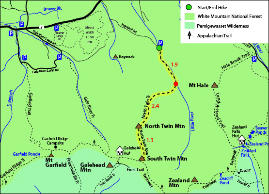
Rollover map for a larger view. Click to download PDF Trail Map of North and South Twin Mountain
|
| |
| South Twin Mountain Photos |
Top |
|
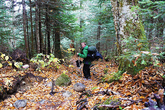
Hiker on the North Twin Spur Trail on October 11, 2012
|
| South Twin Mountain Driving Directions |
Top |
The parking lot for this hike is located on Haystack Road off Route 3 in Bethlehem, New Hampshire.
To get to the North Twin parking lot
Take exit 35 off I-93 onto Route 3 North towards Twin Mountain/Lancaster. Drive 7.9 miles on Route 3 then turn right onto Haystack Road. The parking lot is at the end of the road.
|
|
On this page: Information | Trail maps | View Photos | Driving Directions | Top
|
|
|
|
|
|
|
|
|
|
|
|
|
|
| |
| |
|
| New Hampshire 4,000 Footers |
Vermont + Maine 4,000 Footers |
Other Hiking Lists / Patches |
New England Mountain Ranges |
Stay Involved in New England |
New Hampshire
Mount Adams
Mount Bond
Bondcliff
Mount Bond, West Peak
Mount Cabot
Cannon Mountain
Mount Carrigain
Carter Dome
Carter, Middle
Carter, South
Mount Eisenhower
Mount Field
Mount Flume
Mount Galehead
Mount Garfield
Mount Hale
Mount Hancock
Mount Hancock, South Peak
Mount Isolation
Mount Jackson
Mount Jefferson
Mount Kinsman, North Peak
Mount Kinsman, South Peak
Mount Lafayette
Mount Liberty
Mount Lincoln
Mount Madison
Mount Monroe
Mount Moosilauke
Mount Moriah
Mount Osceola
Mount Osceola, East Peak
Owl's Head
Mount Passaconway
Mount Pierce
Mount Tecumseh
Mount Tom
Mount Tripyramid, Middle Peak
Mount Tripyramid, North Peak
Mount Twin, North Peak
Mount Twin, South Peak
Mount Washington
Mount Waumbek
Mount Whiteface
Mount Wildcat, A Peak
Mount Wildcat, D Peak
Mount Willey
Zealand Mountain |
Vermont
Mount Abraham
Camel's Hump
Mount Ellen
Killington Peak
Mount Mansfield
Maine
Mount Abraham
Mount Bigelow, Avery Peak
Mount Bigelow, West Peak
Crocker Mountain
Crocker Mountain, South
Mount Katahdin, Baxter Peak
Mount Katahdin, Hamlin Peak
North Brother Mountain
Old Speck Mountain
Mount Redington
Saddleback Mountain
Saddleback Mountain, The Horn
Spaulding Mountain
Sugarloaf Mountain |
NH 4,000 footers
NH 4,000 footers in Winter
New England 4,000 footers
NE 4,000 footers in Winter
NH Hundred Highest
New England Fifty Finest
52 With a view
Trailwrights 72 summit club
New England Hundred highest
NE Hundred highest in Winter
Northeast 111
48x12 "The Grid"
Red Lining
Belknap Range
LRCT / Castle in the Clouds
NH Fire Tower Quest
Hike by - Alphabetically
Hike by - Elevation
Hike by - Prominence
Hike by - Mountain Range |
Ranges in New Hampshire
View all NH mountain ranges
Baldface-Royce Range
Carter-Moriah Range
Dartmouth Range
Franconia Range
Kinsman Range
Mahoosuc
Range
Ossipee Mountains
Northern Ranges
Pemigewasset Wilderness
Pilot Range
Pliny Range
Presidential Range
Sandwich Range
Twin Range
Wapack Range
Western White Mountains
Willey Range
Ranges in Maine
View all ME mountain ranges
Baxter State Park
High Peaks
Bigelow Range
Eastern White Mountains
Ranges in Vermont
Green Mountains
Other VT mountain ranges |
NH Waterfalls
NH AMC Huts
Hiker's store |
New England 4,000 Footers | NH 4,000 Footers | VT 4,000 Footers | ME 4,000 Footers | Hiking Lists & Patches | Hiker's Store | Contact by email
© www.4000footers.com 2015. All rights reserved. We are not affiliated with the AMC or the AMC Four Thousand Footer Club |
|
|


