|
|
|
Hiking Saddleback the Horn |
| |
| On this page: Information | Trail maps | View Photos | Driving Directions |
| |
| Saddleback the Horn Information |
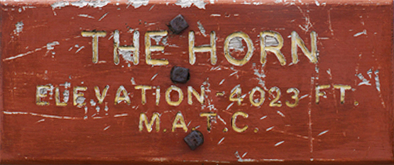
Elevation: 4,041 feet (1,232 meters)
Prominence:  470 feet (143 meters) 470 feet (143 meters)
Location: Rangeley, Maine (Franklin County)
Range: High Peaks
Coordinates: 44°57'05"' North 70°29'14" West
Rating: Moderate
Features: Peak bag , Saddleback Maine Ski Resort
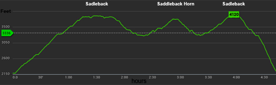
Distance of highlighted hike below: 6.8 miles with Saddleback Mountain
|
 |
Saddleback the Horn is a 4,041 foot mountain in the High Peaks in Rangeley, Maine in Franklin County. The Horn is flanked to the Southwest by Saddleback Mountain, to the Northeast by Saddleback Junior and to the Northwest by Potato Nubble.
The mountain is also known for its ski resort: Saddleback Maine Ski Resort, which is on the north side of Saddleback Mountain. The mountain rock is primarily granodiorite, which is similar to granite, but contains more plagioclase feldspar than orthoclase feldspar and formed more than 400 million years ago.
The Appalachian Trail, which spans from Georgia to Maine, runs along the ridge of Saddleback crossing over the summit of that and the Horn.
This is a great mountain to hike along with Saddleback Mountain, being only 1.6 miles apart. Both summits have 360 degree views on a clear day. Views of the lakes region are breath-taking.
|
| Saddleback the Horn Trail Maps - Directions from the parking lot to the summit |
Top |
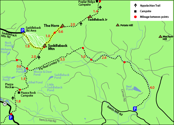
The map below shows how to get to the summit of Saddleback the Horn as well as Saddleback Mountain and will summit Saddleback first.
Begin at the base lodge and follow the road up the Wheeler Slope to the Grey Ghost and Tri Color trails. Tri Color will bring you to the top of the Kenebago Quad, where a short, narrow trail behind the upper building leads to Saddleback's summit.
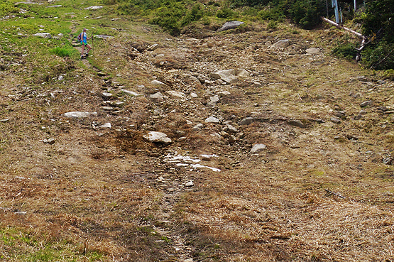
The trail up is rocky, and has a beaten path the entire way. (It is not like a typical ski slope where you would expect grass). At the top, you will be going left onto the Appalachian Trail. (When you first get up there, you have to go back down and over a small bump in the mountain to get to the actual summit.)
To head over to the Horn from the summit of Saddleback Mountain, continue on the Appalachian Trail for 1.6 miles.
To get back to the Saddleback Ski Area parking lot, retrace your steps back over Saddleback Mountain and down the Grey Ghost Ski trail.
Rollover the map below for a closer view
Click to download PDF Trail Map of Saddleback the Horn
|
| |
|
| |
| Saddleback the Horn View Photos |
Top |
|
Heading up the Saddleback ski trails - Grey Ghost Trail
on June 11, 2014.
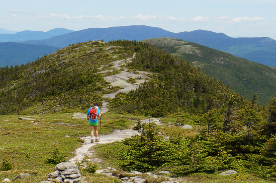
Appalachian Trail between Saddleback Mountain and The Horn on June 11, 2014.
|
| Saddleback the Horn Driving Directions |
Top |
The parking area for this hike is at the Saddleback Maine Ski Resort on Saddleback Mountain Road in Rangeley, Maine. Take Route 16 North, which is East in Maine, to Rangeley, merging and continuing to stay on Route 4 South. Take a left onto Dallas Hill Road, then a right onto the Saddleback Ski Area access road. Parking is available just above the Main Lodge. There are a few parking areas next to the base lodge.
If you have a GPS, just put in Saddleback Mountain Road in Rangeley and drive to the end where the ski area is.
Need a car spot or taxi?
There is a local small business called All Points Transportation run by a man named Greg in the Carrabassett Valley area who can help! If you need a car spot to a trailhead or for any other reason, give him a call to see if he is available. 207-329-3482. |
|
| |
On this page: Information | Trail maps | View Photos | Driving Directions | Top
|
|
|
|
|
|
|
|
|
|
|
|
|
|
| |
| |
|
| New Hampshire 4,000 Footers |
Vermont + Maine 4,000 Footers |
Other Hiking Lists / Patches |
New England Mountain Ranges |
Stay Involved in New England |
New Hampshire
Mount Adams
Mount Bond
Bondcliff
Mount Bond, West Peak
Mount Cabot
Cannon Mountain
Mount Carrigain
Carter Dome
Carter, Middle
Carter, South
Mount Eisenhower
Mount Field
Mount Flume
Mount Galehead
Mount Garfield
Mount Hale
Mount Hancock
Mount Hancock, South Peak
Mount Isolation
Mount Jackson
Mount Jefferson
Mount Kinsman, North Peak
Mount Kinsman, South Peak
Mount Lafayette
Mount Liberty
Mount Lincoln
Mount Madison
Mount Monroe
Mount Moosilauke
Mount Moriah
Mount Osceola
Mount Osceola, East Peak
Owl's Head
Mount Passaconway
Mount Pierce
Mount Tecumseh
Mount Tom
Mount Tripyramid, Middle Peak
Mount Tripyramid, North Peak
Mount Twin, North Peak
Mount Twin, South Peak
Mount Washington
Mount Waumbek
Mount Whiteface
Mount Wildcat, A Peak
Mount Wildcat, D Peak
Mount Willey
Zealand Mountain |
Vermont
Mount Abraham
Camel's Hump
Mount Ellen
Killington Peak
Mount Mansfield
Maine
Mount Abraham
Mount Bigelow, Avery Peak
Mount Bigelow, West Peak
Crocker Mountain
Crocker Mountain, South
Mount Katahdin, Baxter Peak
Mount Katahdin, Hamlin Peak
North Brother Mountain
Old Speck Mountain
Mount Redington
Saddleback Mountain
Saddleback Mountain, The Horn
Spaulding Mountain
Sugarloaf Mountain |
NH 4,000 footers
NH 4,000 footers in Winter
New England 4,000 footers
NE 4,000 footers in Winter
NH Hundred Highest
New England Fifty Finest
52 With a view
Trailwrights 72 summit club
New England Hundred highest
NE Hundred highest in Winter
Northeast 111
48x12 "The Grid"
Red Lining
Belknap Range
LRCT / Castle in the Clouds
NH Fire Tower Quest
Hike by - Alphabetically
Hike by - Elevation
Hike by - Prominence
Hike by - Mountain Range |
Ranges in New Hampshire
View all NH mountain ranges
Baldface-Royce Range
Carter-Moriah Range
Dartmouth Range
Franconia Range
Kinsman Range
Mahoosuc
Range
Ossipee Mountains
Northern Ranges
Pemigewasset Wilderness
Pilot Range
Pliny Range
Presidential Range
Sandwich Range
Twin Range
Wapack Range
Western White Mountains
Willey Range
Ranges in Maine
View all ME mountain ranges
Baxter State Park
High Peaks
Bigelow Range
Eastern White Mountains
Ranges in Vermont
Green Mountains
Other VT mountain ranges |
NH Waterfalls
NH AMC Huts
Hiker's store |
New England 4,000 Footers | NH 4,000 Footers | VT 4,000 Footers | ME 4,000 Footers | Hiking Lists & Patches | Hiker's Store | Contact by email
© www.4000footers.com 2015. All rights reserved. We are not affiliated with the AMC or the AMC Four Thousand Footer Club |
|
|


