| View all NH 4,000 Footers |
| Mount Adams |
| Mount Bond |
| Bondcliff |
| Mount Bond, West Peak |
| Mount Cabot |
| Cannon Mountain |
| Mount Carrigain |
| Carter Dome |
| Carter, Middle |
| Carter, South |
| Mount Eisenhower |
| Mount Field |
| Mount Flume |
| Mount Galehead |
| Mount Garfield |
| Mount Hale |
| Mount Hancock |
| Mount Hancock, South Peak |
| Mount Isolation |
| Mount Jackson |
| Mount Jefferson |
| Mount Kinsman, North Peak |
| Mount Kinsman, South Peak |
| Mount Lafayette |
| Mount Liberty |
| Mount Lincoln |
| Mount Madison |
| Mount Monroe |
| Mount Moosilauke |
| Mount Moriah |
| Mount Osceola |
| Mount Osceola, East Peak |
| Owl's Head |
| Mount Passaconway |
| Mount Pierce |
| Mount Tecumseh |
| Mount Tom |
| Mount Tripyramid, Middle Peak |
| Mount Tripyramid, North Peak |
| Mount Twin, North Peak |
| Mount Twin, South Peak |
| Mount Washington |
| Mount Waumbek |
| Mount Whiteface |
| Mount Wildcat, A Peak |
| Mount Wildcat, D Peak |
| Mount Willey |
| Zealand Mountain |
| NH Mountain Ranges/ Areas ↓ |
| View all NH Mountain Ranges |
| Baldface-Royce Range |
| Carter-Moriah Range |
| Dartmouth Range |
| Franconia Range |
| Kinsman Range |
| Mahoosuc Range |
| Northern Ranges |
| Ossipee Mountains |
| Pemigewasset Wilderness |
| Pilot Range |
| Pliny Range |
| Presidential Range |
| Sandwich Range |
| Twin Range |
| Wapack Range |
| Willey Range |
|
|
Hike Mount Jackson |
| |
| On this page: Information | Trail maps | View Photos | Driving Directions |
| |
| Mount Jackson Information |
Elevation: 4,052 feet (1,235 meters)
Prominence:  331 feet (101 meters) 331 feet (101 meters)
Location: Twin Mountain (Carroll), NH (Coös County, NH)
Range: Presidential Range
Coordinates: 44°12.19' North 71°22.53' West
Rating: Moderate
Features: Cascades, Rock Scrambles , 360 Degree Views,
Peak Bagging
Distance of highlighted hike below: 5.6 miles
|
 |
Mount Jackson is a 4,052 foot mountain located in Coos County, New Hampshire. The mountain is named after Charles Thomas Jackson, a New Hampshire's geologist in the 19th century. The mountain lies in the Presidential Range of the White Mountains and is flanked to the north by Mount Pierce, and to the southwest by Mount Webster.The Appalachian Trail crosses the summit of Mt. Jackson as it traverses the main ridge of the Presidential Range from Crawford Notch to the summit of Mount Washington.
The views from the summit of Mount Jackson are 360 degrees and stunning. There are also 2 lower elevation outlooks along the shortest trail to the summit, Webster-JacksonTrail, called Elephant Head and Bugle Cliff (2,450 feet).
| For peak-baggers: |
Mount Webster is 1.4 miles from the summit of Mount Jackson
Mount Pierce is 2.5 miles from the summit of Mount Jackson
Mount Eisenhower is roughly 3.5 miles from the summit of Mount Jackson
|
|
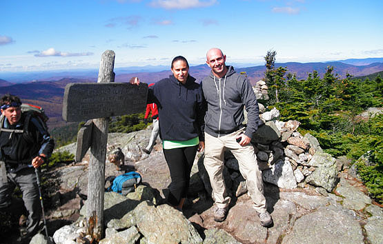
On the summit of Mount Jackson on October 3, 2010.
|
| |
| Mount Jackson Trail Maps - Directions from the parking lot to the summit |
Top |
The trail map below shows how to get to the summit of Mount Jackson via the Webster-Jackson Trail.
You begin on the Webster-Jackson Trail from Route 302 by the AMC Highland Center. After just a short 0.1 miles, you will reach a small trail on the right that leads to Elephant Head. This spot offers great views over Crawford Notch and is worth the short 0.2 mile hike. Once you are back on the Webster-Jackson Trail, continue to head up for 0.5 miles where you will reach a 60 yard trail on the right leading to Bugle Cliff, another lookout ledge over Crawford Notch. Retrace your steps once again to continue up the Webster-Jackson Trail for another 0.8 miles where you will come upon a trail-split. The left side leads to the summit of Mount Jackson and the right leads to Mount Webster after 1.1 miles. Take the left for 1.2 miles until you reach the summit.
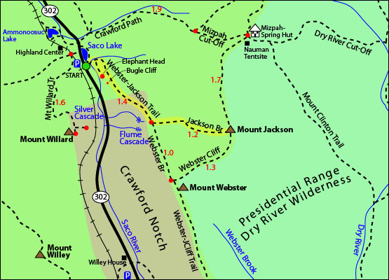
Rollover map above for a closer view. Click to download PDF Trail Map of Mount Jackson
|
| |
|
| |
|
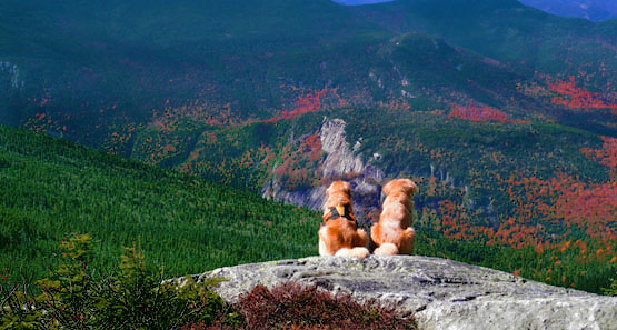
2 Golden Retrievers patiently waiting on the summit for their owners to make it up. October 3, 2010.
Looking down into Crawford Notch.
|
| Mount Jackson Driving Directions |
Top |
The parking lot for the highlighted hike above is at the Webster-Jackson Trail head, located on Route 302 in Twin Mountain (Carroll), New Hampshire.
If you are traveling from the East
The Webster-Jackson Trail Parking Lot is 2.6 miles West of the Willey House Historical Site and 0.1 miles before the AMC Highland Center. The parking lot is on the left hand side, and the trail starts across the street.
If you are traveling from the West
From the junction of Route 3 and Route 302, the Webster-Jackson Trail Parking Lot is 8.5 miles East on Route 302. (0.1 miles after the AMC Highland Center). The parking lot is on the right hand side, and the trail starts across the street. |
|
On this page: Information | Trail maps | View Photos | Driving Directions | Top
|
|
|
|
|
|
|
|
|
|
|
|
|
|
| > |
| |
| |
|
| New Hampshire 4,000 Footers |
Vermont + Maine 4,000 Footers |
Other Hiking Lists / Patches |
New England Mountain Ranges |
Stay Involved in New England |
New Hampshire
Mount Adams
Mount Bond
Bondcliff
Mount Bond, West Peak
Mount Cabot
Cannon Mountain
Mount Carrigain
Carter Dome
Carter, Middle
Carter, South
Mount Eisenhower
Mount Field
Mount Flume
Mount Galehead
Mount Garfield
Mount Hale
Mount Hancock
Mount Hancock, South Peak
Mount Isolation
Mount Jackson
Mount Jefferson
Mount Kinsman, North Peak
Mount Kinsman, South Peak
Mount Lafayette
Mount Liberty
Mount Lincoln
Mount Madison
Mount Monroe
Mount Moosilauke
Mount Moriah
Mount Osceola
Mount Osceola, East Peak
Owl's Head
Mount Passaconway
Mount Pierce
Mount Tecumseh
Mount Tom
Mount Tripyramid, Middle Peak
Mount Tripyramid, North Peak
Mount Twin, North Peak
Mount Twin, South Peak
Mount Washington
Mount Waumbek
Mount Whiteface
Mount Wildcat, A Peak
Mount Wildcat, D Peak
Mount Willey
Zealand Mountain |
Vermont
Mount Abraham
Camel's Hump
Mount Ellen
Killington Peak
Mount Mansfield
Maine
Mount Abraham
Mount Bigelow, Avery Peak
Mount Bigelow, West Peak
Crocker Mountain
Crocker Mountain, South
Mount Katahdin, Baxter Peak
Mount Katahdin, Hamlin Peak
North Brother Mountain
Old Speck Mountain
Mount Redington
Saddleback Mountain
Saddleback Mountain, The Horn
Spaulding Mountain
Sugarloaf Mountain |
NH 4,000 footers
NH 4,000 footers in Winter
New England 4,000 footers
NE 4,000 footers in Winter
NH Hundred Highest
New England Fifty Finest
52 With a view
Trailwrights 72 summit club
New England Hundred highest
NE Hundred highest in Winter
Northeast 111
48x12 "The Grid"
Red Lining
Belknap Range
LRCT / Castle in the Clouds
NH Fire Tower Quest
Hike by - Alphabetically
Hike by - Elevation
Hike by - Prominence
Hike by - Mountain Range |
Ranges in New Hampshire
View all NH mountain ranges
Baldface-Royce Range
Carter-Moriah Range
Dartmouth Range
Franconia Range
Kinsman Range
Mahoosuc
Range
Ossipee Mountains
Northern Ranges
Pemigewasset Wilderness
Pilot Range
Pliny Range
Presidential Range
Sandwich Range
Twin Range
Wapack Range
Western White Mountains
Willey Range
Ranges in Maine
View all ME mountain ranges
Baxter State Park
High Peaks
Bigelow Range
Eastern White Mountains
Ranges in Vermont
Green Mountains
Other VT mountain ranges |
NH Waterfalls
NH AMC Huts
Hiker's store |
New England 4,000 Footers | NH 4,000 Footers | VT 4,000 Footers | ME 4,000 Footers | Hiking Lists & Patches | Hiker's Store | Contact by email
© www.4000footers.com 2015. All rights reserved. We are not affiliated with the AMC or the AMC Four Thousand Footer Club |
|
|


