|
|
|
Hiking Mount Abraham, Maine |
| |
| On this page: Information | Trail maps | View Photos | Driving Directions |
| |
| Mount Abraham Information |
Elevation: 4,050 feet (1,234 meters)
Prominence:  900 feet (274 meters) 900 feet (274 meters)
Location: Mount Abraham, Maine (Franklin County)
Range: High Peaks
Coordinates: 44°58.38' North 70°19.59' West
Rating: Moderate/Difficult
Features: Peak bag , Spaulding Campsite, summit views, Fire Warden's Trail, Mt Abraham Side Trail, Appalachian Trail
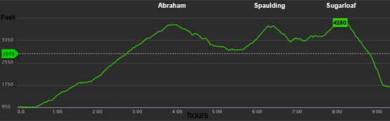
Distance of highlighted hike below: 13.2 miles with Sugarloaf Mountain and Spaulding Mountain. (but you could always just hike Abraham making it just over 8 miles)
|
 |
Mount Abraham is a 4,050 foot mountain in the High Peaks of Franklin County, Maine. There are really nice views on the summit of this mountain.
On November 14, 1967, a supersonic jet fighter (McDonnell F-101 Voodoo), which served the United States Air Force and the Royal Canadian Air Force collided with another F-101B during a cross-country formation flight. The two-man crew was ejected from the aircraft suffering only minor injuries while the other aircraft made an emergency landing at Bangor Air National Guard Base. To learn about other crash sites on New England mountains visit this page: plane crashes.
Summit of Mount Abraham on June 9, 2014.
|
| Mount Abraham Trail Maps - Directions from the parking lot to the summit |
Top |
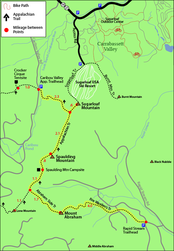
The map below shows how to get to the summit of Mount Abraham, as well as Sugarloaf Mountain and Spaulding Mountain.
This hike is a traverse from the Fire Warden's Trail up Mount Abraham to the Caribou Valley Road Appalachian Trail crossing after Sugarloaf Mountain, so you will need a car spot (car at the beginning and end of the hike). There is a local taxi service phone number below in the driving directions for hikers!
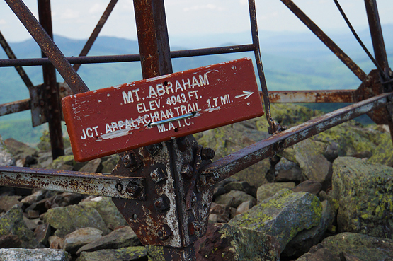
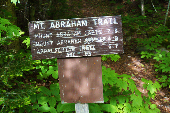
Hike up the Fire Warden's Trail for 4 miles and you will reach the open summit of Mount Abraham. There is a non-climbable tower as well as a hidden rock shelter. After enjoying views on this summit, continue hiking another 1.7 miles (the trail name changes to the Mt Abraham Side Trail.) There was no sign with trail names or which way to go on June 2014, but the only 2 trails coming off the summit of Abraham is the Fire Warden's Trail and the Mt Abraham Side Trail. (Well technically you could say there are 3 trails coming off the summit. The 3rd being the South Side Trail. This trail is not on most maps and is mainly used by locals since you have to drive on many unnamed old logging roads to get to the unmarked traillhead. This website might be of help with directions.)
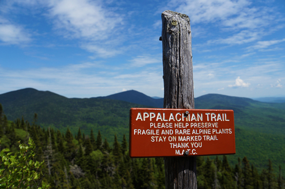
After the 1.7 miles, you will be at the Appalachian Trail junction where you will turn right onto the Appalachian Trail. Hike for 1.1 miles where you will come to a little junction with the Spaulding Mountain Campsite. Staying on the Appalachian Trail, continue another 0.8 miles to the summit of Spaulding Mountain.
To head over to Sugarloaf Mountain, continue along the Appalachian Trail for 2.1 miles until you come to a junction with the Sugarloaf Trail. Turn onto this trail and hike the last 0.6 miles to Sugarloaf's summit.
From the summit of Sugarloaf, rehike the last 0.6 miles you just did on the Sugarloaf Trail to get back to the Appalachian Trail. From the junction, go right on the Appalachian Trail for 2.3 miles where you will reach Caribou Valley Road.
Another option: From the summit of Sugarloaf: instead of hiking back to the Appalachian Trail, you can hike down the ski trails (if it is not ski season). This is the shorter route, but also rather difficult to hike ski trails. You would need a car spot for this option as well.
Rollover the map below for a closer view
Click to download PDF Trail Map of Mount Abraham
|
| |
| |
| Mount Abraham View Photos |
Top |
|
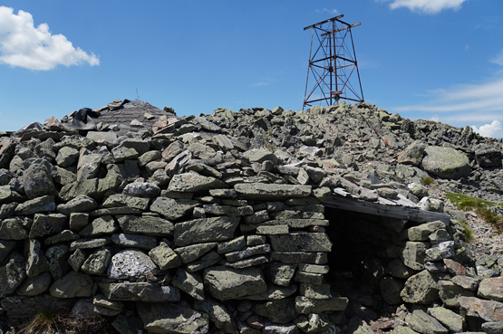
Summit of Mount Abraham on June 9, 2014. Tower and rock shelter.
Heading up the Fire Warden's Trail to the summit of Mount Abraham on June 9, 2014.
Beginning of the Fire Warden's Trail heading up to Mount Abraham on June 9, 2014.
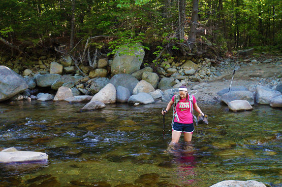
The second river crossing on the way to the Fire Warden's Trailhead June 9, 2014.
|
| Mount Abraham Driving Directions |
Top |
NOTE: This hike might require some road walking because a couple bridges have washed out on Rapid Stream Road. Word is that they will not be replaced anytime soon. So you will have to park before the washed out bridges.
To get to the Rapid Stream Trailhead parking area for the Fire Warden's Trail:
From Sugarloaf USA Ski Resort, drive 14.7 miles South on Route 16 / 27. Turn right onto West Kingfield Road. Drive 3.5 miles. (This road will become a dirt road at the 3.3 mile mark). Right after the road turns to a dirt road, you will come to a 4 way intersection. Go straight through this. This is Rapid Stream Road. Drive 2.6 miles on this rough rocky road where you will reach a major fork. Take the left fork, and you will have to park near this area, because as you will see, the bridge over Rapid Stream has been damaged and fallen, so your hike will start before the actual trailhead and you will have to cross the river on foot. (There is a second bridge after the first that was also damaged, so you will have to cross this on foot as well. This 2nd river crossing can be difficult if the water is high, and might require you to take off your shoes.)
To get to the Caribou Valley Road (Caribou Pond Road) Appalachian Trail crossing parking area:
Take Route 27 northwest from the entrance to Sugarloaf ski area. It is roughly 1 mile from the Sugarloaf entrance to Caribou Valley Road (also called Caribou Pond Road) and will be on the left. This road was not signed in June 2014. The trail for this hike is 4.4 miles up the road. There is a small clearing for parking just before this. The trail is not signed from the road and can be easy to miss, but if you track it, is is 4.4 miles from the beginning of the road on the left.
When you are driving on Caribou Valley Road, you will pass several bridges (two that are wood, and in terrible condition, and one that is metal right before a hill), so you will have to use your judgment whether or not your vehicle can drive over this, otherwise some people opt to park before the bridges and walk the rest. It is unclear if these bridges will be replaced, but as of June 2014 they are still damaged.
Need a car spot or taxi?
There is a local small business called All Points Transportation run by a man named Greg in the Carrabassett Valley area who can help! If you need a car spot to a trailhead or for any other reason, give him a call to see if he is available. 207-329-3482. |
|
| |
On this page: Information | Trail maps | View Photos | Driving Directions | Top
|
|
|
|
|
|
| |
|
|
|
|
|
|
| |
|
|
| New Hampshire 4,000 Footers |
Vermont + Maine 4,000 Footers |
Other Hiking Lists / Patches |
New England Mountain Ranges |
Stay Involved in New England |
New Hampshire
Mount Adams
Mount Bond
Bondcliff
Mount Bond, West Peak
Mount Cabot
Cannon Mountain
Mount Carrigain
Carter Dome
Carter, Middle
Carter, South
Mount Eisenhower
Mount Field
Mount Flume
Mount Galehead
Mount Garfield
Mount Hale
Mount Hancock
Mount Hancock, South Peak
Mount Isolation
Mount Jackson
Mount Jefferson
Mount Kinsman, North Peak
Mount Kinsman, South Peak
Mount Lafayette
Mount Liberty
Mount Lincoln
Mount Madison
Mount Monroe
Mount Moosilauke
Mount Moriah
Mount Osceola
Mount Osceola, East Peak
Owl's Head
Mount Passaconway
Mount Pierce
Mount Tecumseh
Mount Tom
Mount Tripyramid, Middle Peak
Mount Tripyramid, North Peak
Mount Twin, North Peak
Mount Twin, South Peak
Mount Washington
Mount Waumbek
Mount Whiteface
Mount Wildcat, A Peak
Mount Wildcat, D Peak
Mount Willey
Zealand Mountain |
Vermont
Mount Abraham
Camel's Hump
Mount Ellen
Killington Peak
Mount Mansfield
Maine
Mount Abraham
Mount Bigelow, Avery Peak
Mount Bigelow, West Peak
Crocker Mountain
Crocker Mountain, South
Mount Katahdin, Baxter Peak
Mount Katahdin, Hamlin Peak
North Brother Mountain
Old Speck Mountain
Mount Redington
Saddleback Mountain
Saddleback Mountain, The Horn
Spaulding Mountain
Sugarloaf Mountain |
NH 4,000 footers
NH 4,000 footers in Winter
New England 4,000 footers
NE 4,000 footers in Winter
NH Hundred Highest
New England Fifty Finest
52 With a view
Trailwrights 72 summit club
New England Hundred highest
NE Hundred highest in Winter
Northeast 111
48x12 "The Grid"
Red Lining
Belknap Range
LRCT / Castle in the Clouds
NH Fire Tower Quest
Hike by - Alphabetically
Hike by - Elevation
Hike by - Prominence
Hike by - Mountain Range |
Ranges in New Hampshire
View all NH mountain ranges
Baldface-Royce Range
Carter-Moriah Range
Dartmouth Range
Franconia Range
Kinsman Range
Mahoosuc
Range
Ossipee Mountains
Northern Ranges
Pemigewasset Wilderness
Pilot Range
Pliny Range
Presidential Range
Sandwich Range
Twin Range
Wapack Range
Western White Mountains
Willey Range
Ranges in Maine
View all ME mountain ranges
Baxter State Park
High Peaks
Bigelow Range
Eastern White Mountains
Ranges in Vermont
Green Mountains
Other VT mountain ranges |
NH Waterfalls
NH AMC Huts
Hiker's store |
New England 4,000 Footers | NH 4,000 Footers | VT 4,000 Footers | ME 4,000 Footers | Hiking Lists & Patches | Hiker's Store | Contact by email
© www.4000footers.com 2015. All rights reserved. We are not affiliated with the AMC or the AMC Four Thousand Footer Club |
|
|


