| View all NH 4,000 Footers |
| Mount Adams |
| Mount Bond |
| Bondcliff |
| Mount Bond, West Peak |
| Mount Cabot |
| Cannon Mountain |
| Mount Carrigain |
| Carter Dome |
| Carter, Middle |
| Carter, South |
| Mount Eisenhower |
| Mount Field |
| Mount Flume |
| Mount Galehead |
| Mount Garfield |
| Mount Hale |
| Mount Hancock |
| Mount Hancock, South Peak |
| Mount Isolation |
| Mount Jackson |
| Mount Jefferson |
| Mount Kinsman, North Peak |
| Mount Kinsman, South Peak |
| Mount Lafayette |
| Mount Liberty |
| Mount Lincoln |
| Mount Madison |
| Mount Monroe |
| Mount Moosilauke |
| Mount Moriah |
| Mount Osceola |
| Mount Osceola, East Peak |
| Owl's Head |
| Mount Passaconway |
| Mount Pierce |
| Mount Tecumseh |
| Mount Tom |
| Mount Tripyramid, Middle Peak |
| Mount Tripyramid, North Peak |
| Mount Twin, North Peak |
| Mount Twin, South Peak |
| Mount Washington |
| Mount Waumbek |
| Mount Whiteface |
| Mount Wildcat, A Peak |
| Mount Wildcat, D Peak |
| Mount Willey |
| Zealand Mountain |
| NH Mountain Ranges/ Areas ↓ |
| View all NH Mountain Ranges |
| Baldface-Royce Range |
| Carter-Moriah Range |
| Dartmouth Range |
| Franconia Range |
| Kinsman Range |
| Mahoosuc Range |
| Northern Ranges |
| Ossipee Mountains |
| Pemigewasset Wilderness |
| Pilot Range |
| Pliny Range |
| Presidential Range |
| Sandwich Range |
| Twin Range |
| Wapack Range |
| Willey Range |
|
|
Hike Mount Isolation |
| |
| On this page: Information | Trail maps | View Photos | Driving Directions |
| |
| Mount Isolation Information |
Elevation: 4,003 feet (1,220 meters)
Prominence:  203 feet (62 meters) 203 feet (62 meters)
Location: Pinkham Notch, (Coös County)
Range: Presidential Range
Coordinates: 44°12.88' North 71°18.58' West
Rating: Moderate
Features: Rocky Branch River, Dry River Wilderness, Glen Boulder, Slide Peak
Distance of highlighted hike below: 12 miles
|
 |
Mount Isolation is a 4,003 foot mountain located in the Dry River Wilderness. It is situated in the Presidential Range in the White Mountains. Mount Isolation is the highest peak in the Montalban Ridge, which extends from South from Boott Spur.
Mount Isolation one of the White Mountains most remote peaks, and is also the second shortest mountain, out of the NH 4,000 Footers list. It is just 1 foot taller than Mount Tecumseh, the shortest one.
| For peak-baggers: |
Mount Davis is 1.4 miles from the summit of Mount Isolation
Slide Peak is roughly 3.3 miles from the summit of Mount Isolation
Boott Spur is roughly 3.3 miles from the summit of Mount Isolation
Stairs Mountain is 5.5 miles from the summit of Mount Isolation
|
|
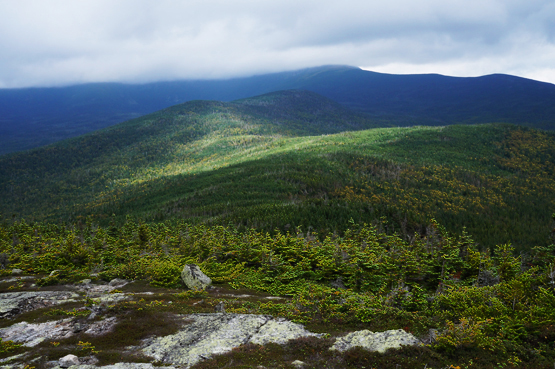
Views from the summit of Mount Isolation in August, 2013. |
| |
| |
| Mount Isolation Trail Maps - Directions from the parking lot to the summit |
Top |
The trail map below shows how to get to the summit of Mount Isolation via the Glen Boulder Trail, and the Davis Path.
From the Glen Ellis Parking area, hike along the Glen Boulder Trail 3.2 miles. (You will pass a junction with the Avalanche Brook Ski Trail after 0.8 miles, and hike over Slide Peak about 1.8 miles after that.) Glen Boulder is 1.6 miles from the parking lot. (Glen Boulder is a HUGE boulder, as the name says, in the middle of the Glen Boulder Trail, and can be seen from Route 16.)
After you hiked 3.2 miles on the Glen Boulder Trail and reach the junction with The Davis Path, turn left onto the Davis Path. Hike for 1.6 miles until you reach a junction with Isolation Trail. Stay left onto the Davis Path for 0.3 miles where you will find another junction with the Isolation Trail. Stay straight/right along the Davis Path for 0.9 miles until you reach the summit of Mount Isolation. To return to the parking lot, retrace your steps the way you came up.
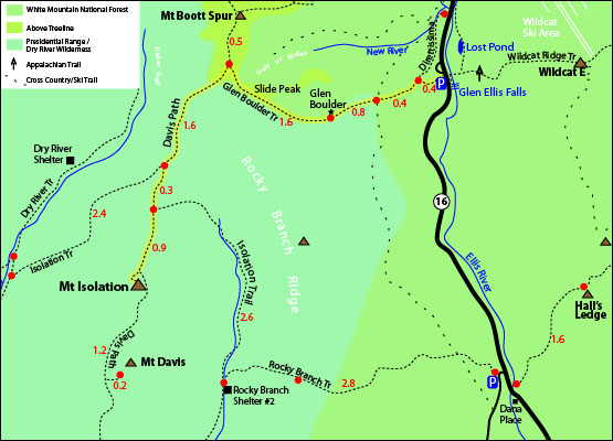
Rollover map for larger view. Click to download PDF Trail Map of Mount Isolation
|
| |
| |
| Mount Isolation Photos |
Top |
|
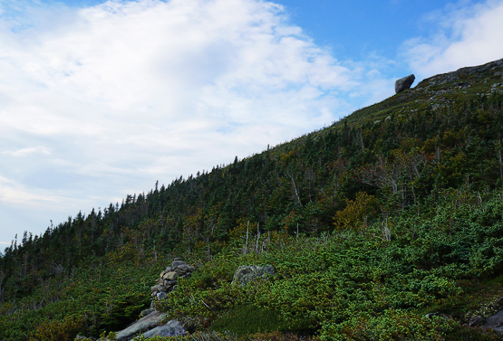
Glen Boulder in the distance from the Glen Boulder Trail.
|
| Mount Isolation Driving Directions |
Top |
The parking lot for the highlighted hike above is located on Route 16 at the Glen Ellis Parking Area.
From the South:
Take exit 4 off I-95 North to merge onto Route 16 North / US 4 West. Follow Route 16 up past Jackson, NH. Look for signs for the Glen Ellis Parking Area on the left. If you drive to Wildcat Ski Area, you drove one parking lot too far.
Be sure to check out Glen Ellis Falls before or after your hike. Well worth the visit!
|
|
On this page: Information | Trail maps | View Photos | Driving Directions | Top
|
|
|
|
|
|
|
|
|
|
|
|
|
|
| |
| |
| |
|
| New Hampshire 4,000 Footers |
Vermont + Maine 4,000 Footers |
Other Hiking Lists / Patches |
New England Mountain Ranges |
Stay Involved in New England |
New Hampshire
Mount Adams
Mount Bond
Bondcliff
Mount Bond, West Peak
Mount Cabot
Cannon Mountain
Mount Carrigain
Carter Dome
Carter, Middle
Carter, South
Mount Eisenhower
Mount Field
Mount Flume
Mount Galehead
Mount Garfield
Mount Hale
Mount Hancock
Mount Hancock, South Peak
Mount Isolation
Mount Jackson
Mount Jefferson
Mount Kinsman, North Peak
Mount Kinsman, South Peak
Mount Lafayette
Mount Liberty
Mount Lincoln
Mount Madison
Mount Monroe
Mount Moosilauke
Mount Moriah
Mount Osceola
Mount Osceola, East Peak
Owl's Head
Mount Passaconway
Mount Pierce
Mount Tecumseh
Mount Tom
Mount Tripyramid, Middle Peak
Mount Tripyramid, North Peak
Mount Twin, North Peak
Mount Twin, South Peak
Mount Washington
Mount Waumbek
Mount Whiteface
Mount Wildcat, A Peak
Mount Wildcat, D Peak
Mount Willey
Zealand Mountain |
Vermont
Mount Abraham
Camel's Hump
Mount Ellen
Killington Peak
Mount Mansfield
Maine
Mount Abraham
Mount Bigelow, Avery Peak
Mount Bigelow, West Peak
Crocker Mountain
Crocker Mountain, South
Mount Katahdin, Baxter Peak
Mount Katahdin, Hamlin Peak
North Brother Mountain
Old Speck Mountain
Mount Redington
Saddleback Mountain
Saddleback Mountain, The Horn
Spaulding Mountain
Sugarloaf Mountain |
NH 4,000 footers
NH 4,000 footers in Winter
New England 4,000 footers
NE 4,000 footers in Winter
NH Hundred Highest
New England Fifty Finest
52 With a view
Trailwrights 72 summit club
New England Hundred highest
NE Hundred highest in Winter
Northeast 111
48x12 "The Grid"
Red Lining
Belknap Range
LRCT / Castle in the Clouds
NH Fire Tower Quest
Hike by - Alphabetically
Hike by - Elevation
Hike by - Prominence
Hike by - Mountain Range |
Ranges in New Hampshire
View all NH mountain ranges
Baldface-Royce Range
Carter-Moriah Range
Dartmouth Range
Franconia Range
Kinsman Range
Mahoosuc
Range
Ossipee Mountains
Northern Ranges
Pemigewasset Wilderness
Pilot Range
Pliny Range
Presidential Range
Sandwich Range
Twin Range
Wapack Range
Western White Mountains
Willey Range
Ranges in Maine
View all ME mountain ranges
Baxter State Park
High Peaks
Bigelow Range
Eastern White Mountains
Ranges in Vermont
Green Mountains
Other VT mountain ranges |
NH Waterfalls
NH AMC Huts
Hiker's store |
New England 4,000 Footers | NH 4,000 Footers | VT 4,000 Footers | ME 4,000 Footers | Hiking Lists & Patches | Hiker's Store | Contact by email
© www.4000footers.com 2015. All rights reserved. We are not affiliated with the AMC or the AMC Four Thousand Footer Club |
|
|


