| View all NH 4,000 Footers |
| Mount Adams |
| Mount Bond |
| Bondcliff |
| Mount Bond, West Peak |
| Mount Cabot |
| Cannon Mountain |
| Mount Carrigain |
| Carter Dome |
| Carter, Middle |
| Carter, South |
| Mount Eisenhower |
| Mount Field |
| Mount Flume |
| Mount Galehead |
| Mount Garfield |
| Mount Hale |
| Mount Hancock |
| Mount Hancock, South Peak |
| Mount Isolation |
| Mount Jackson |
| Mount Jefferson |
| Mount Kinsman, North Peak |
| Mount Kinsman, South Peak |
| Mount Lafayette |
| Mount Liberty |
| Mount Lincoln |
| Mount Madison |
| Mount Monroe |
| Mount Moosilauke |
| Mount Moriah |
| Mount Osceola |
| Mount Osceola, East Peak |
| Owl's Head |
| Mount Passaconway |
| Mount Pierce |
| Mount Tecumseh |
| Mount Tom |
| Mount Tripyramid, Middle Peak |
| Mount Tripyramid, North Peak |
| Mount Twin, North Peak |
| Mount Twin, South Peak |
| Mount Washington |
| Mount Waumbek |
| Mount Whiteface |
| Mount Wildcat, A Peak |
| Mount Wildcat, D Peak |
| Mount Willey |
| Zealand Mountain |
| NH Mountain Ranges/ Areas ↓ |
| View all NH Mountain Ranges |
| Baldface-Royce Range |
| Carter-Moriah Range |
| Dartmouth Range |
| Franconia Range |
| Kinsman Range |
| Mahoosuc Range |
| Northern Ranges |
| Ossipee Mountains |
| Pemigewasset Wilderness |
| Pilot Range |
| Pliny Range |
| Presidential Range |
| Sandwich Range |
| Twin Range |
| Wapack Range |
| Willey Range |
|
|
Hike Mount Flume |
| |
| On this page: Information | Trail maps | View Photos | Driving Directions |
| |
Elevation: 4,328 feet (1,319 meters)
Prominence:  408 feet (124 meters) 408 feet (124 meters)
Location: Lincoln, NH (Grafton County, New Hampshire)
Range: Franconia Range
Coordinates: 44°06'32" North 71°37'40" West
Rating: Very Difficult once you hit the Flume Ledges
Features: Brooks, Peak Bagging , 360 Degree Views, Flume Ledges, Flume Brook, Alpine Zone
Distance of highlighted hike below: 10.1 miles with Mt. Liberty (or hike just Flume at 7.8 miles)
|
 |
Mount Flume is a 4,328 foot mountain in the Franconia Range of the White Mountains overlooking Franconia Notch. It is one of 6 mountains in the Franconia Range, though, only 4 of them being 4,000 footers. Mount Flume is the shortest.
Many people choose to hike Mount Flume and Mount Liberty on the same hike, this is known as Peak-Bagging (also mountain bagging, hill bagging, summit to summit). It is a great way to cross multiple mountains off your list in one day, and not to mention have multiple views! If you choose to hike both mountains, it is wise to hike up to Mount Flume via the Flume Slide Trail, then over to Mount Liberty, and down the Liberty Spring Trail, which is also part of the Appalachian Trail. The Flume Slide Trail is extremely steep for around a mile starting at the summit. It is called the Flume Ledges. Both the views on each mountain are incredible and breath-taking.
The shortest trail up to the summit of Flume is via the Flume Slide Trail, and would take 9.6 miles there and back. (But again, it is not a good idea to hike down the Flume Slide Trail, especially when it is wet out.) It will take 10.1 miles to peak-bag both Liberty and Flume.
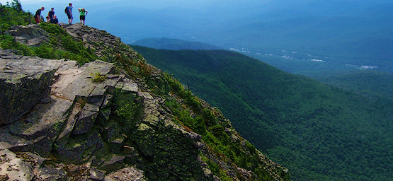
Summit of Mount Flume on August 14, 2011
|
|
| |
| Mount Flume Trail Maps - Directions from the parking lot to the summit |
Top |
The map below shows how to get to the summit of Mount Flume, as well as Mount Liberty.
This is a loop hike (see map below) starting at the Whitehouse Trail head at the Flume Visitor Center. From the parking lot, you will start the hike off by hiking 0.9 miles almost parallel to the highway (some of which is a bike path). Then at the junction turn to get towards Liberty Spring Trail, which is also part of the Appalachian Trail. Hike for 0.6 miles until you come to a fork where you can turn right to head up Mount Liberty, or Left to head up Mount Flume via the Flume Slide Trail. (GO RIGHT. It is not a good idea to end up having to hike down Mount Flume due to its incredible steepness on the Flume Ledges.) It is 3.3 miles until you reach the summit of Mount Flume (roughly 4 hours for the average hiker.) After you enjoy the views on the summit of Flume, continue over the summit for 1.2 miles until you reach the summit of Mount Liberty. To head back down to the parking lot, start your hike down on the Liberty Spring Trail. Hike for 0.3 miles until you come to a junction where you will turn left. (If you stay right, you will end up at Little Haystack Mountain in 1.9 miles). Once on the Liberty Spring Trail, hike down for 2.9 miles until you reach a junction where you will head left for the last 0.9 miles (partly on the paved bike path) until you reach the parking lot.
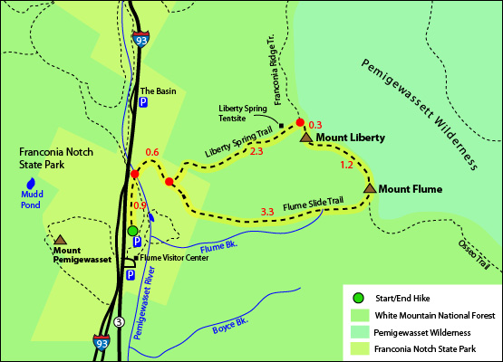
Click to download PDF Trail Map of Mount Flume
|
| |
| |
|
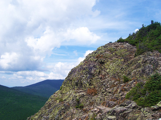
Looking up to the summit of Mount Flume. Photo taken on August 14, 2011.
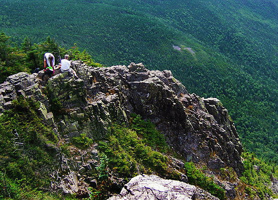
Right below the summit of Mount Flume on August 14, 2011.
|
| Mount Flume Driving Directions |
Top |
The parking lot for this hike is near the Flume Visitor Center at the Whitehouse Trail head Parking Lot, off exit 34A on I-93 in Lincoln, New Hampshire. If you are driving and pass The Basin, you drove too far. |
|
On this page: Information | Trail maps | View Photos | Driving Directions | Top
|
|
|
|
|
|
|
|
|
|
|
|
|
|
| |
| |
| |
|
| New Hampshire 4,000 Footers |
Vermont + Maine 4,000 Footers |
Other Hiking Lists / Patches |
New England Mountain Ranges |
Stay Involved in New England |
New Hampshire
Mount Adams
Mount Bond
Bondcliff
Mount Bond, West Peak
Mount Cabot
Cannon Mountain
Mount Carrigain
Carter Dome
Carter, Middle
Carter, South
Mount Eisenhower
Mount Field
Mount Flume
Mount Galehead
Mount Garfield
Mount Hale
Mount Hancock
Mount Hancock, South Peak
Mount Isolation
Mount Jackson
Mount Jefferson
Mount Kinsman, North Peak
Mount Kinsman, South Peak
Mount Lafayette
Mount Liberty
Mount Lincoln
Mount Madison
Mount Monroe
Mount Moosilauke
Mount Moriah
Mount Osceola
Mount Osceola, East Peak
Owl's Head
Mount Passaconway
Mount Pierce
Mount Tecumseh
Mount Tom
Mount Tripyramid, Middle Peak
Mount Tripyramid, North Peak
Mount Twin, North Peak
Mount Twin, South Peak
Mount Washington
Mount Waumbek
Mount Whiteface
Mount Wildcat, A Peak
Mount Wildcat, D Peak
Mount Willey
Zealand Mountain |
Vermont
Mount Abraham
Camel's Hump
Mount Ellen
Killington Peak
Mount Mansfield
Maine
Mount Abraham
Mount Bigelow, Avery Peak
Mount Bigelow, West Peak
Crocker Mountain
Crocker Mountain, South
Mount Katahdin, Baxter Peak
Mount Katahdin, Hamlin Peak
North Brother Mountain
Old Speck Mountain
Mount Redington
Saddleback Mountain
Saddleback Mountain, The Horn
Spaulding Mountain
Sugarloaf Mountain |
NH 4,000 footers
NH 4,000 footers in Winter
New England 4,000 footers
NE 4,000 footers in Winter
NH Hundred Highest
New England Fifty Finest
52 With a view
Trailwrights 72 summit club
New England Hundred highest
NE Hundred highest in Winter
Northeast 111
48x12 "The Grid"
Red Lining
Belknap Range
LRCT / Castle in the Clouds
NH Fire Tower Quest
Hike by - Alphabetically
Hike by - Elevation
Hike by - Prominence
Hike by - Mountain Range |
Ranges in New Hampshire
View all NH mountain ranges
Baldface-Royce Range
Carter-Moriah Range
Dartmouth Range
Franconia Range
Kinsman Range
Mahoosuc
Range
Ossipee Mountains
Northern Ranges
Pemigewasset Wilderness
Pilot Range
Pliny Range
Presidential Range
Sandwich Range
Twin Range
Wapack Range
Western White Mountains
Willey Range
Ranges in Maine
View all ME mountain ranges
Baxter State Park
High Peaks
Bigelow Range
Eastern White Mountains
Ranges in Vermont
Green Mountains
Other VT mountain ranges |
NH Waterfalls
NH AMC Huts
Hiker's store |
New England 4,000 Footers | NH 4,000 Footers | VT 4,000 Footers | ME 4,000 Footers | Hiking Lists & Patches | Hiker's Store | Contact by email
© www.4000footers.com 2015. All rights reserved. We are not affiliated with the AMC or the AMC Four Thousand Footer Club |
|
|


