| View all NH 4,000 Footers |
| Mount Adams |
| Mount Bond |
| Bondcliff |
| Mount Bond, West Peak |
| Mount Cabot |
| Cannon Mountain |
| Mount Carrigain |
| Carter Dome |
| Carter, Middle |
| Carter, South |
| Mount Eisenhower |
| Mount Field |
| Mount Flume |
| Mount Galehead |
| Mount Garfield |
| Mount Hale |
| Mount Hancock |
| Mount Hancock, South Peak |
| Mount Isolation |
| Mount Jackson |
| Mount Jefferson |
| Mount Kinsman, North Peak |
| Mount Kinsman, South Peak |
| Mount Lafayette |
| Mount Liberty |
| Mount Lincoln |
| Mount Madison |
| Mount Monroe |
| Mount Moosilauke |
| Mount Moriah |
| Mount Osceola |
| Mount Osceola, East Peak |
| Owl's Head |
| Mount Passaconway |
| Mount Pierce |
| Mount Tecumseh |
| Mount Tom |
| Mount Tripyramid, Middle Peak |
| Mount Tripyramid, North Peak |
| Mount Twin, North Peak |
| Mount Twin, South Peak |
| Mount Washington |
| Mount Waumbek |
| Mount Whiteface |
| Mount Wildcat, A Peak |
| Mount Wildcat, D Peak |
| Mount Willey |
| Zealand Mountain |
| NH Mountain Ranges/ Areas ↓ |
| View all NH Mountain Ranges |
| Baldface-Royce Range |
| Carter-Moriah Range |
| Dartmouth Range |
| Franconia Range |
| Kinsman Range |
| Mahoosuc Range |
| Northern Ranges |
| Ossipee Mountains |
| Pemigewasset Wilderness |
| Pilot Range |
| Pliny Range |
| Presidential Range |
| Sandwich Range |
| Twin Range |
| Wapack Range |
| Willey Range |
|
|
Hike Carter Dome, Carter Middle and Carter South |
| |
| On this page: Information | Trail maps | View Photos | Driving Directions |
| |
| Carter Dome, Carter Middle and Carter South Information |
Carter Dome Elevation: 4,832 feet (1,473 meters)
Carter Middle Elevation: 4,610 feet (1,402 meters)
Carter South Elevation: 4,430 feet (1,347 meters)
Carter Dome Prominence:  2,830 feet (863 meters) 2,830 feet (863 meters)
Carter Middle Prominence: 720 feet (219 meters)
Carter South Prominence: 230 feet (70 meters)
Location: Coös County, NH
Range: Carter-Moriah Range
Carter Dome Coordinates: 43°16'01" North 71°10'44" West
Carter Middle Coordinates: 44°18'11" North 71°10'02" West
Carter South Coordinates: 44°17'23" North 071°10'34" West
Rating: Difficult
Features: Peak Bagging , Carter Notch Hut, Carter Lakes,
Nineteen Mile Brook, Carter Notch, Appalachian Trail
Distance of highlighted hike below: 14.8 miles (roughly 1.5 is on the road, unless you have another car to pick you up since this hike described and pictured below starts and ends at 2 different locations.)
|
 |
Carter Dome Mountain is a 4,832 foot mountain in the White Mountains. It sits in the Carter-Moriah Range, which runs along the northeastern side of Pinkham Notch. There are rumors that the mountain is named after a hunter named Carter, and a neighboring peak, Mount Hight, is named after his hunting partner, Hight.
Middle Carter Mountain is a 4,610 foot mountain, also in the White Mountains is part of the Carter-Moriah Range. The summit itself is wooded, so there are no views. But you can enjoy some great views shortly before and after the summit along the Carter-Moriah Trail, which is also part of the Appalachian Trail.
South Carter Mountain is a 4,430 foot mountain in the White Mountains. It sits in the Carter-Moriah Range. The summit itself is wooded, so there are no views. But you can enjoy some great views shortly before and after the summit of Middle Carter Mountain along the Carter-Moriah Trail, which is also part of the Appalachian Trail.
| For peak-baggers: |
Mount Hight is 0.8 miles from the summit of Carter Dome
Mount Hight is 2.7 miles from the summit of Middle Carter Mountain
Mount Hight is 1.4 miles from the summit of South Carter Mountain
Wildcat Mountain, Peak A, is 2 miles from the summit of Carter Dome
South Carter Mountain is 2 miles from the summit of Carter Dome
South Carter Mountain is 1.3 miles from the summit of Middle Carter Mountain
Middle Carter is 3.3 miles form the summit of Carter Dome Mountain
North Carter Mountain is 0.9 miles from the summit of Middle Carter Mountain
North Carter Mountain is 2.2 miles from the summit of South Carter Mountain
|
|
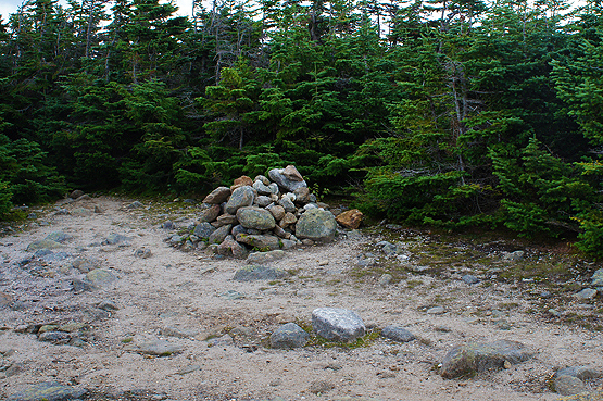
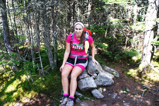
Summit cairn on Carter Dome Mountain on 8/22/2012 |
| |
| Carter Dome, Carter Middle and Carter South Trail Maps - Directions |
Top |
The map below shows how to get to the summit of Carter Dome as well as South Carter and Middle Carter Mountain. (NOTE: A car spot is needed for this particular hike described and pictured below, as you will be starting and ending the hike in 2 different spots.)
Begin at the Nineteen Mile Brook Trail Parking lot. Hike up the Nineteen Mile Brook Trail for 1.9 miles until you reach a junction with the Carter Dome Trail. Stay left onto the Carter Dome Trail for 1.9 miles where you will come to a junction with the Zeta Pass on the right, and the Carter-Moriah Trail / Appalachian Trail on the left. Stay left on the Carter-Moriah Trail and hike for 0.8 miles until you reach the summit of South Carter Mountain. To continue over to Middle Carter Mountain, continue along the Carter-Moriah Trail for another 1.3 miles where you will reach the summit of Middle Carter Mountain. You can enjoy incredible views of Mount Washington on a clear day between the two mountains just before Middle Carter Mountain.
To begin your descent to the parking lot, continue hiking along the Carter-Moriah Trail for 0.6 miles until you reach a junction with the North Carter Trail on your right. Take the North Carter Trail for 1.2 miles until you reach a junction with the IMP Trail. Take the IMP Trail down to route 16 for 3.3 miles. (If you have someone who can pick you up from the road, here is where they can get you.) Turn left onto route 16. You will walk the last part of your hike on route 16 for roughly 1.5 miles until you reach the Nineteen Mile Brook Parking Lot.
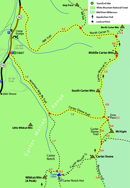
Click to download PDF Trail Map of Carter Dome Mountain, Carter South and Carter Middle
|
| |
| |
| Carter Dome, Carter Middle and Carter South Photos |
Top |
|
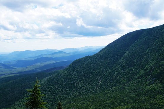
Views along the Carter-Moriah Trail between South and Middle Carter Mountains on 8/22/2012
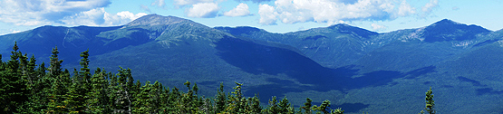
Views near the summit of Carter Dome Mountain on 8/22/2012
Summit cairn on Middle Carter Mountain on 8/22/2012
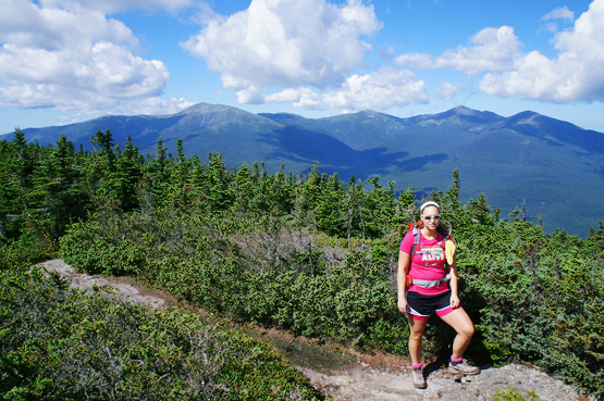
Views along the Carter-Moriah Trail between South and Middle Carter Mountains on 8/22/2012
|
| Carter Dome, Carter Middle and Carter South Driving Directions |
Top |
From the South:
Take exit 35 off I-93 where you will end up on US-3 / N towards Twin Mountain / Lancaster. Continue 12.3 miles and turn right onto NH 115 N. Drive 9.6 miles and turn right onto US-2 E / Presidential Hwy. Drive 12.5 miles and turn right onto Main Street. Drive 1.4 miles and turn NH-16 S / Glen Road. Drive roughly 6.8 miles until you see the Nineteen Mile Brook Parking Lot on the left side.
|
|
On this page: Information | Trail maps | View Photos | Driving Directions | Top
|
|
|
|
|
|
|
|
|
|
|
|
|
|
| |
| |
|
| New Hampshire 4,000 Footers |
Vermont + Maine 4,000 Footers |
Other Hiking Lists / Patches |
New England Mountain Ranges |
Stay Involved in New England |
New Hampshire
Mount Adams
Mount Bond
Bondcliff
Mount Bond, West Peak
Mount Cabot
Cannon Mountain
Mount Carrigain
Carter Dome
Carter, Middle
Carter, South
Mount Eisenhower
Mount Field
Mount Flume
Mount Galehead
Mount Garfield
Mount Hale
Mount Hancock
Mount Hancock, South Peak
Mount Isolation
Mount Jackson
Mount Jefferson
Mount Kinsman, North Peak
Mount Kinsman, South Peak
Mount Lafayette
Mount Liberty
Mount Lincoln
Mount Madison
Mount Monroe
Mount Moosilauke
Mount Moriah
Mount Osceola
Mount Osceola, East Peak
Owl's Head
Mount Passaconway
Mount Pierce
Mount Tecumseh
Mount Tom
Mount Tripyramid, Middle Peak
Mount Tripyramid, North Peak
Mount Twin, North Peak
Mount Twin, South Peak
Mount Washington
Mount Waumbek
Mount Whiteface
Mount Wildcat, A Peak
Mount Wildcat, D Peak
Mount Willey
Zealand Mountain |
Vermont
Mount Abraham
Camel's Hump
Mount Ellen
Killington Peak
Mount Mansfield
Maine
Mount Abraham
Mount Bigelow, Avery Peak
Mount Bigelow, West Peak
Crocker Mountain
Crocker Mountain, South
Mount Katahdin, Baxter Peak
Mount Katahdin, Hamlin Peak
North Brother Mountain
Old Speck Mountain
Mount Redington
Saddleback Mountain
Saddleback Mountain, The Horn
Spaulding Mountain
Sugarloaf Mountain |
NH 4,000 footers
NH 4,000 footers in Winter
New England 4,000 footers
NE 4,000 footers in Winter
NH Hundred Highest
New England Fifty Finest
52 With a view
Trailwrights 72 summit club
New England Hundred highest
NE Hundred highest in Winter
Northeast 111
48x12 "The Grid"
Red Lining
Belknap Range
LRCT / Castle in the Clouds
NH Fire Tower Quest
Hike by - Alphabetically
Hike by - Elevation
Hike by - Prominence
Hike by - Mountain Range |
Ranges in New Hampshire
View all NH mountain ranges
Baldface-Royce Range
Carter-Moriah Range
Dartmouth Range
Franconia Range
Kinsman Range
Mahoosuc
Range
Ossipee Mountains
Northern Ranges
Pemigewasset Wilderness
Pilot Range
Pliny Range
Presidential Range
Sandwich Range
Twin Range
Wapack Range
Western White Mountains
Willey Range
Ranges in Maine
View all ME mountain ranges
Baxter State Park
High Peaks
Bigelow Range
Eastern White Mountains
Ranges in Vermont
Green Mountains
Other VT mountain ranges |
NH Waterfalls
NH AMC Huts
Hiker's store |
New England 4,000 Footers | NH 4,000 Footers | VT 4,000 Footers | ME 4,000 Footers | Hiking Lists & Patches | Hiker's Store | Contact by email
© www.4000footers.com 2015. All rights reserved. We are not affiliated with the AMC or the AMC Four Thousand Footer Club |
|
|


