| View all NH 4,000 Footers |
| Mount Adams |
| Mount Bond |
| Bondcliff |
| Mount Bond, West Peak |
| Mount Cabot |
| Cannon Mountain |
| Mount Carrigain |
| Carter Dome |
| Carter, Middle |
| Carter, South |
| Mount Eisenhower |
| Mount Field |
| Mount Flume |
| Mount Galehead |
| Mount Garfield |
| Mount Hale |
| Mount Hancock |
| Mount Hancock, South Peak |
| Mount Isolation |
| Mount Jackson |
| Mount Jefferson |
| Mount Kinsman, North Peak |
| Mount Kinsman, South Peak |
| Mount Lafayette |
| Mount Liberty |
| Mount Lincoln |
| Mount Madison |
| Mount Monroe |
| Mount Moosilauke |
| Mount Moriah |
| Mount Osceola |
| Mount Osceola, East Peak |
| Owl's Head |
| Mount Passaconway |
| Mount Pierce |
| Mount Tecumseh |
| Mount Tom |
| Mount Tripyramid, Middle Peak |
| Mount Tripyramid, North Peak |
| Mount Twin, North Peak |
| Mount Twin, South Peak |
| Mount Washington |
| Mount Waumbek |
| Mount Whiteface |
| Mount Wildcat, A Peak |
| Mount Wildcat, D Peak |
| Mount Willey |
| Zealand Mountain |
| NH Mountain Ranges/ Areas ↓ |
| View all NH Mountain Ranges |
| Baldface-Royce Range |
| Carter-Moriah Range |
| Dartmouth Range |
| Franconia Range |
| Kinsman Range |
| Mahoosuc Range |
| Northern Ranges |
| Ossipee Mountains |
| Pemigewasset Wilderness |
| Pilot Range |
| Pliny Range |
| Presidential Range |
| Sandwich Range |
| Twin Range |
| Wapack Range |
| Willey Range |
| Maine 4,000 Footers ↓ |
| View all ME 4,000 footers |
| Mount Abraham |
| Mount Bigelow, Avery Peak |
| Mount Bigelow, West Peak |
| Crocker Mountain |
| Crocker Mountain, South |
| Mount Katahdin, Baxter Peak |
| Mount Katahdin, Hamlin Peak |
| North Brother Mountain |
| Old Speck Mountain |
| Mount Redington |
| Saddleback Mountain |
| Saddleback Mountain, The Horn |
| Spauling Mountain |
| Sugarloaf Mountain |
| Maine Mountain Ranges / Areas ↓ |
| View all ME Mountain Ranges |
| Baxter State Park |
| High Peaks |
| Bigelow Range |
| Eastern White Mountains |
| Vermont 4,000 Footers ↓ |
| View all VT 4,000 Footers |
| Mount Abraham |
| Camel's Hump |
| Mount Ellen |
| Killington Peak |
| Mount Mansfield |
| VT Mountain Ranges/ Areas ↓ |
| Green Mountains |
| View other VT Mountain Ranges |
|
|
Hike to New England plane crash sites |
| |
There are tons of place crash sites throughout New England and many that you can hike to and still see remains of old planes from from the 1940s to the 1970s.
Below is a list of some of the mountains you can hike to visit a place crash site
| Camel's Hump, Vermont, 1944 |
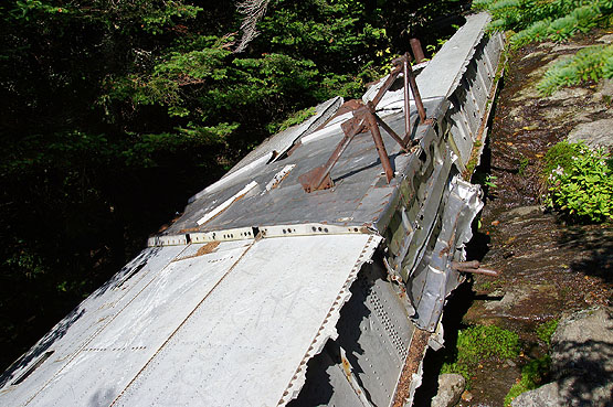
In October 1944 during World War II, a B-27J Bomber plane on a training mission crashed into the side of the mountain near the summit. Most of the wreckage has been removed, but parts of a wing still exist on the Alpine Trail just about 0.4 miles from the summit.
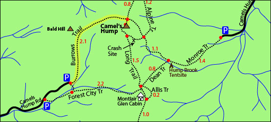
To visit the site, you will need to get on the Alpine Trail (see map below showing where the plane crash site is). Once you reach the "X" area on the map, look for a herd path that leads into the woods off the Alpine Trail on the left. You can see the plane before you hike onto that path. To learn more info about Camel's Hump Mountain, visit the Camel's Hump page where there is a detailed trail map.
Rollover the small photos below to see the larger version.
 |
| |
 |
 |
 |
 |
 |
| |
| Rollover the small photos above to see the larger version. |

|
|
| Mount Abraham, Vermont, 1973 |
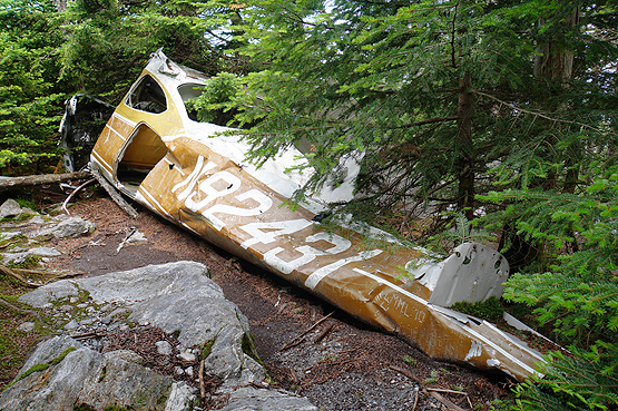
On June 28, 1973, a pilot was trying to navigate through a thick cloud and struck some trees at roughly 3,000 feet elevation on Mount Abraham. He was on his way from Twin Mountain, Vermont to Newburgh, New York. Cessna 182N Registration Number N92431. The pilot survived. To learn more about Mount Abraham, visit the Mt .Abraham page.
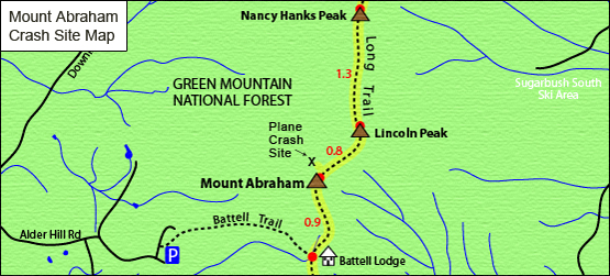
Enjoy some photos below of the wreck site. To find this plane, hike over Mount Abraham heading North on the Long Trail for roughly a hundred feet. There will be a herd path on the left (There was a small cairn in July of 2014 indicating the trail.) The 5th photo below is the unmarked path you will take off the Long Trail to get to the crash site.
Rollover the small photos below to see the larger version.
 |
| |
 |
 |
 |
 |
 |
| |
| Rollover the small photos above to see the larger version. |
|

Click to download PDF Trail Map of Mount Abraham with the crash site pointed out
|
| |
| Mount Success, New Hampshire, 1954 |
On November 30, 1954, Northeast Airlines Flight 792 departed Laconia, NH, at 10:37am bound for Berlin, NH. Onboard the twin-engine Douglas DC-3 were pilot Peter Carey, first officer George McCormick, stewardess Mary McEtrick, superintend ant John C. McNulty, and three passengers: James Harvey, William Miller, and Daniel Hall. Snow and poor weather through the pilot off course, so he attempted to fly the plane by instruments. The pilots quick thinking drove him to shut off all electricity before the crash landing to prevent an explosion which most likely would have killed all 7 on board. Fore more detailed information on this crash visit this page. This hike is roughly 3.2 miles to reach the crash site (one way). |
|
| Mount Waternomee, New Hampshire, 1942 |
| On January 14, 1942, a Douglas B-18 Bolo Bomber returning to Westover Air Force Base in Chicopee, Massachusetts from a patrol over the North Atlantic Ocean for German submarines crashed into the south side of Mount Waternomee in the White Mountains of New Hampshire. This explosion was so loud and the flames were visible from surrounding towns. The cause of this crash was due to poor weather conditions, and the pilot ended up flying in the wrong direction. The pilot did recognize he was off course, but at that point it was too late; they were moments away from crashing into the mountain. Amazingly 5 out of the 7 men aboard the plane survived due to the pilots smart quick thinking of lifting the plane's nose upwards to avoid a nose-dive crash. This hike is roughly 3 miles to reach the crash site (one way). |
|
| Blood Mountain, New Hampshire, 1949 |
| On November 20, 1949, John Moses, the only (pilot) person on board, got lost in the clouds and crashed while flying from Bridgeport, Connecticut to Boston. He crashed just short of the summit of Blood Mountain. The Rockwell AT-6 was a two-seater, single engine craft. The cause of the crash was the pilot's failure to maintain an altitude high enough to clear the peak, and the poor weather conditions. The plane's remains are only about 30 yards from the tree line of the mountain. This hike is roughly 1.25 miles to reach the crash site (one way). |
| |
| Fort Mountain, Maine, 1942 |
| On June 20, 1944, a C-54-A cargo plane (TWA flight 277) crashed into Fort Mountain. All 7 passengers on board died which included 6 civilian crew members and 1 United States Air Force passenger. The aircraft experienced severe weather including heavy rain, high wind and lightning. These weather conditions forced the aircraft to blow 70 feet off course. The pilot, Roger "Rolley" Inman did not know he was flying below 4,000 feet and hit Fort Mountain at about 3,700 feet. Some of the remains of the plane are still on Fort Mountain and allow the curios and ambitious hikers to go visit the site via a difficult bushwhack from North Brother Mountain because there is no maintained trail to Fort Mountain or the crash site. |
| |
|
|
|

