| 52 with a View List ↓ |
| Mount Avalon |
| Baldface, North |
| Baldface, South |
| Black Mountain, (Benton) |
| Black Mountain, Middle (Jackson) |
| Blueberry Mountain |
| Mount Cardigan |
| Mount Chocorua |
| Mount Crawford |
| Mount Cube |
| Doublehead, North |
| Eagle Crag (Mt. Meader) |
| Eastman Mountain |
| Mount Hayes |
| Hedgehog Mountain |
| Mount Hibbard |
| Horn, The |
| Imp Face |
| Iorn Mountain |
| Mount Israel |
| Jennings Peak |
| Mount Kearsarge |
| Kearsarge North |
| Magalloway Mountain |
| Mount Martha (Cherry / Owls Head) |
| Moat Mountain, North |
| Moat Mountain, South |
| Mount Monadnock |
| Mount Parker |
| Mount Paugus |
| Mount Pemigewasset |
| Percy Peaks, North Peak |
| Potash Mountain |
| Mount Resolution |
| Mount Roberts |
| Royce Mountain, West |
| Sandwich Dome |
| Mount Shaw |
| Shelburne Moriah Mountain |
| Sisters, Middle |
| Smarts Mountain |
| Square Ledge |
| Stairs Mountain |
| Mount Starr King |
| Stinson Mountain |
| Mount Success |
| Sugarloaf Mountain |
| Sugarloaf Mountain, Middle |
| Mount Tremont |
| Mount Webster |
| Welch / Dickey Mountain |
| Mount Willard |
|
|
Hike Stinson Mountain |
| |
| On this page: Information | Trail maps | View Photos | Driving Directions |
| |
| Stinson Mountain Information |
Elevation: 2,900 feet (883 meters)
Location: Rumney, NH
Rating:  Low incline trail with no rock ledges or scrambles (except the summit, which is all bare rock) Low incline trail with no rock ledges or scrambles (except the summit, which is all bare rock)
Features: Bare rock summit with 180 degree views, 52 with a View
Distance of highlighted hike below: 3.6 miles via the Stinson Mountain Trail. (or 4.10 if you have to walk Doetown Road).
|
 |
Stinson Mountain is a 2,900 foot mountain in Rumney, NH.
The only trail up to the summit of Stinson Mountain is the Stinson Mountain Trail off Doetown Road. The mountain was once home to a fire tower that has since been removed, but you can see the tower footings on the summit, which makes for good seating after your hike up!
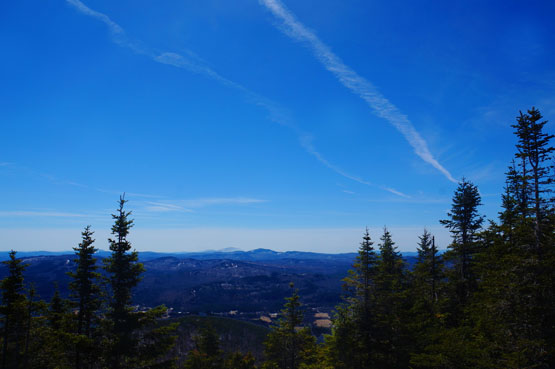
Photo taken from the summit of Stinson Mountain on 4-19-2015.
|
| Stinson Mountain Trail Maps |
Top |
The map below shows how to get to the summit of Stinson Mountain.
From the traillhead off Doetown Road in Rumney, NH (see driving directions towards the bottom of the page), hike up the Stinson Mountian Trail for 1.1 miles until you reach a junction with a snowmobile trail. You can continue up the snowmobile trail to reach the summit, or veer right onto the "hiking trail" as signed. Each way is 0.7 miles to the summit.
(There are seveal other snowmobile trails crossing the main hiking trail, so be sure to stay on the Stinson Mountain Trail. Or to make a loop hike, when you come to the trail junction [see photo below] with the "hiking trail" to the right and the "snow machine trail" to the left, you can take the left to the summit also.)
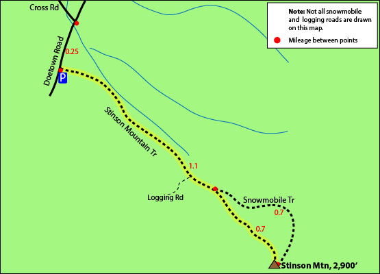
Click to download PDF Trail Map of Stinson Mountain
|
| |
| Stinson Mountain Photos |
Top |
|
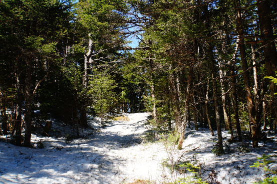
Photo taken from the Stinson Mountain Trail on 4-19-2015.
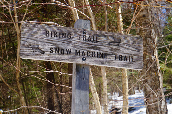
Photo taken from the Stinson Mountain Trail on 4-19-2015. (The hiking trail is to the left and the snowmobile trail is so the right).
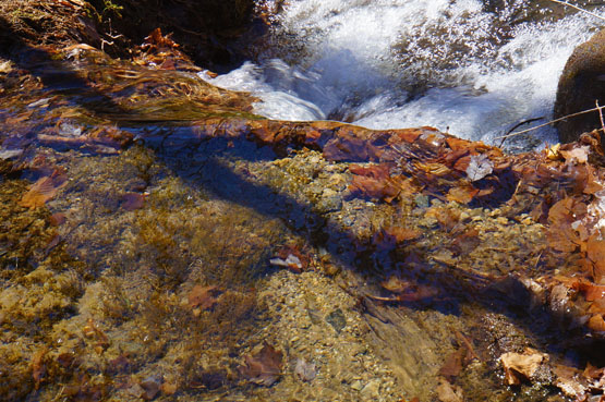
There is a lot of streams all around the Stinson Mountain Trail.
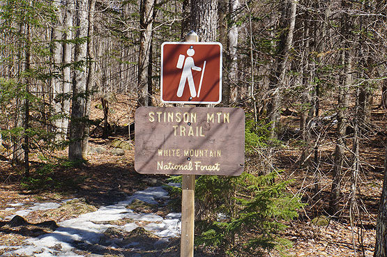
Photo taken from the Stinson Mountain Traillhead on 4-19-2015.
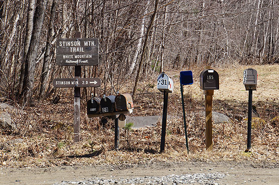
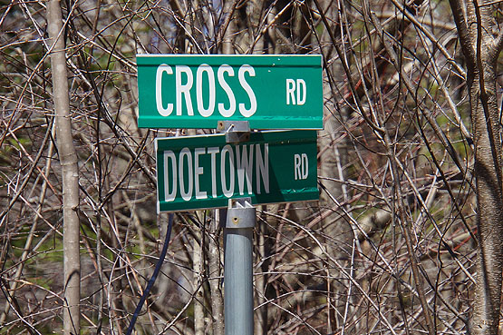
Photo taken from the intersection of Cross Road and Doetown Road in Rumney, NH. If Doetown Road is unplowed or too muddy to drive on to get to the actual traillhead and parking area, people have been known to park here on the side of the road and walk the 0.25 miles on Doetown Road to get to the traillhead.
|
| Stinson Mountain Driving Directions |
Top |
These are driving directions to the Stinson mountain Trail Traillhead Parking lot:
Take exit 26 off I-93 to route 3A South, which eventually turns into 25 West. After 4 miles from the highway, you will reach a traffic circle. Take the first exit at the traffic circle to NH 25 West (Mt Moosilauke Highway). Drive 3.4 miles and turn right onto Main Street. Drive 1 mile and take a slight left onto Stinson Lake Road. Drive 4 miles and turn right onto Cross Road. Drive 0.8 miles and you will find yourself at the intersection of Cross Road and Doetown Road. (People have been known to park here on the side of the road and walk the 0.25 miles on Doetown Road on the right to get to the traillhead if it is unplowed in Winter or too muddy to drive on). But if the road is driveable, turn right onto Doetown Road and the parking area and traillhead is just a quarter of a mile on the left.
|
|
On this page: Information | Trail maps | View Photos | Driving Directions | Top
|
|
|
|
|
|
|
|
|
|
| |
|
|
|
| |
| New Hampshire 4,000 Footers |
Vermont + Maine 4,000 Footers |
Other Hiking Lists / Patches |
New England Mountain Ranges |
Stay Involved in New England |
New Hampshire
Mount Adams
Mount Bond
Bondcliff
Mount Bond, West Peak
Mount Cabot
Cannon Mountain
Mount Carrigain
Carter Dome
Carter, Middle
Carter, South
Mount Eisenhower
Mount Field
Mount Flume
Mount Galehead
Mount Garfield
Mount Hale
Mount Hancock
Mount Hancock, South Peak
Mount Isolation
Mount Jackson
Mount Jefferson
Mount Kinsman, North Peak
Mount Kinsman, South Peak
Mount Lafayette
Mount Liberty
Mount Lincoln
Mount Madison
Mount Monroe
Mount Moosilauke
Mount Moriah
Mount Osceola
Mount Osceola, East Peak
Owl's Head
Mount Passaconway
Mount Pierce
Mount Tecumseh
Mount Tom
Mount Tripyramid, Middle Peak
Mount Tripyramid, North Peak
Mount Twin, North Peak
Mount Twin, South Peak
Mount Washington
Mount Waumbek
Mount Whiteface
Mount Wildcat, A Peak
Mount Wildcat, D Peak
Mount Willey
Zealand Mountain |
Vermont
Mount Abraham
Camel's Hump
Mount Ellen
Killington Peak
Mount Mansfield
Maine
Mount Abraham
Mount Bigelow, Avery Peak
Mount Bigelow, West Peak
Crocker Mountain
Crocker Mountain, South
Mount Katahdin, Baxter Peak
Mount Katahdin, Hamlin Peak
North Brother Mountain
Old Speck Mountain
Mount Redington
Saddleback Mountain
Saddleback Mountain, The Horn
Spaulding Mountain
Sugarloaf Mountain |
NH 4,000 footers
NH 4,000 footers in Winter
New England 4,000 footers
NE 4,000 footers in Winter
NH Hundred Highest
New England Fifty Finest
52 With a view
Trailwrights 72 summit club
New England Hundred highest
NE Hundred highest in Winter
Northeast 111
48x12 "The Grid"
Red Lining
Belknap Range
LRCT / Castle in the Clouds
NH Fire Tower Quest
Hike by - Alphabetically
Hike by - Elevation
Hike by - Prominence
Hike by - Mountain Range |
Ranges in New Hampshire
View all NH mountain ranges
Baldface-Royce Range
Carter-Moriah Range
Dartmouth Range
Franconia Range
Kinsman Range
Mahoosuc
Range
Ossipee Mountains
Northern Ranges
Pemigewasset Wilderness
Pilot Range
Pliny Range
Presidential Range
Sandwich Range
Twin Range
Wapack Range
Western White Mountains
Willey Range
Ranges in Maine
View all ME mountain ranges
Baxter State Park
High Peaks
Bigelow Range
Eastern White Mountains
Ranges in Vermont
Green Mountains
Other VT mountain ranges |
NH Waterfalls
NH AMC Huts
Hiker's store |
New England 4,000 Footers | NH 4,000 Footers | VT 4,000 Footers | ME 4,000 Footers | Hiking Lists & Patches | Hiker's Store | Contact by email
© www.4000footers.com 2015. All rights reserved. We are not affiliated with the AMC or the AMC Four Thousand Footer Club |
|
|


