| New England 100 Highest List ↓ |
| Mount Abraham - Maine |
| Mount Abraham - Vermont |
| Mount Adams |
| Baldpate Mountain |
| Mount Bigelow, Avery Peak |
| Mount Bigelow, West Peak |
| Mount Bigelow, South Horn |
| Big Jay |
| Mount Bond |
| Bondcliff |
| Mount Bond, West Peak |
| Boundary Peak |
| Bread Loaf Mountain |
| Mount Cabot |
| Camel's Hump |
| Cannon Mountain |
| Cannon Ball, Northeast Peak |
| Mount Carrigain |
| Carter Dome |
| Carter, Middle |
| Carter, South |
| Mount Coe |
| Crocker Mountain |
| Crocker Mountain, South |
| Dorset Mountain |
| Mount Eisenhower |
| Elephant Mountain |
| Mount Ellen |
| Equinox Mountain |
| Mount Field |
| Mount Flume |
| Fort Mountain |
| Mount Galehead |
| Mount Garfield |
| Goose Eye Mountain |
| Mount Hale |
| Mount Hancock |
| Mount Hancock, South Peak |
| Mount Isolation |
| Mount Jackson |
| Jay Peak |
| Mount Jefferson |
| Mount Katahdin, Baxter Peak |
| Mount Katahdin, Hamlin Peak |
| Kennebago Divide |
| East Kennebago Mountain |
| Killington Peak |
| Mount Kinsman, North Peak |
| Mount Kinsman, South Peak |
| Mount Lafayette |
| Mount Liberty |
| Mount Lincoln |
| Mount Madison |
| Mount Mansfield |
| Mendon Peak |
| Mount Monroe |
| Mount Moosilauke |
| Mount Moriah |
| Mount Nancy |
| North Brother Mountain |
| Old Speck Mountain |
| Mount Osceola |
| Mount Osceola, East Peak |
| Owl's Head |
| Mount Passaconway |
| Peak Above the Nubble (PATN) |
| Pico Peak |
| Mount Pierce |
| Mount Redington |
| Saddleback Mountain |
| Saddleback Mountain, The Horn |
| Sandwich Mountain |
| Scar Ridge |
| Sleeper, East Peak |
| Snow Mountain - Franklin County |
| Snow Mountain - Oxford County |
| South Brother |
| Spauling Mountain |
| Stratton Mountain |
| Sugarloaf Mountain |
| Mount Tecumseh |
| The Bulge |
| The Horn |
| Mount Tom |
| Mount Tripyramid, Middle Peak |
| Mount Tripyramid, North Peak |
| Mount Twin, North Peak |
| Mount Twin, South Peak |
| Vose Spur |
| Mount Washington |
| Mount Waumbek |
| Mount Weeks |
| Mount Weeks, South |
| White Cap Mountain |
| Mount Whiteface |
| Mount Wildcat, A Peak |
| Mount Wildcat, D Peak |
| Mount Willey |
| Mount Wilson |
Zealand Mountain |
|
|
Hike The Horn |
| |
| On this page: Information | Trail maps | View Photos | Driving Directions |
| |
Elevation: 3,905 feet (1,190 meters)
Prominence:  246 feet (75 meters) 246 feet (75 meters)
Location: Berlin, New Hampshire (Coos County)
Range: Pilot Range
Coordinates: 44°31.08' North 71°24.01" West
Rating: Easy/ Moderate - The only really tricky part of this hike is getting on the summit of The Horn, because it is made up of several large boulders that can be difficult to get up. The length of this hike is also quite long.
Features: Peak Bag, Unknown Pond, Cabot Cabin
Distance of highlighted hike below: 11.5 miles with The Bulge and Mount Cabot.
|
 |
The Horn is a 3,905 foot mountain in the Pilot Range in New Hampshire's northernmost county; Coös County. The Horn is flanked to the Southwest by The Bulge.
Unknown Pond is located to the Northeast of The Horn and has spectacular views of the peak across the pond on a clear day. The trails to the summit are relatively easy, but the summit itself is large boulders that can be a bit tricky to get on top of.
The Horn, The Bulge and Mount Cabot are all on the New England Hundred highest hiking list.
|
| The Horn Trail Maps - Directions from the parking lot to the summit |
Top |
The map below shows how to get to the summit of The Horn as well as The Bulge and Mount Cabot via a nice loop hike.
From the Unknown Pond parking area near the Berlin Fish Hatchery off Bog Dam Road, you will have to walk on the road for a few minutes to the start of Bunnell Notch Trail on the left side of the road. Hike on the Bunnell Notch Trail for 0.2 miles and you will come to a junction with the York Pond Trail. Stay right on the Bunnell Notch Trail and hike for 2.8 more miles until you come to a junction with the Kilkenny Ridge Trail. Stay straight for less than 1/10 of a mile and fork right onto the Kilkenny Ridge Trail. Hike for 1.6 miles until you reach the summit of Mount Cabot (You will pass a junction after 0.3 miles to head back to the Bunnell Notch Trail, and you will also pass Cabot Cabin).
After enjoying the summit of Mount Cabot, continue along the Kilkenny Ridge Trail for roughly 0.7 miles where you will find yourself on the summit of The Bulge. To continue over to The Horn, continue along the Kilkenny Ridge Trail for roughly 0.4 miles until you come to a spur trail on the right that heads up to The Horn in a short 0.3 mile ascent.
To head back down to the car (via the loop hike), go back down the 0.3 mile spur trail that headed up to The Horn, and continue (to the right) on the Kilkenny Ridge Trail for 1.7 miles until you come to a junction with the Unknown Pond Trail (and the actual Unknown Pond). Here you will go right onto the Unknown Pond Trail. (Left will take you to a different parking lot on Mill Brook Road in Stark, NH). Hike for 3.3 miles on the Unknown Pond Trail back down to the parking lot near the Berlin Fish Hatchery.
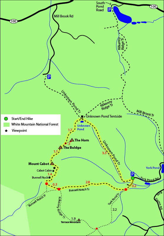
Click to download PDF Trail Map of The Bulge as well as The Horn and Mount Cabot
|
| |
|
| |
|
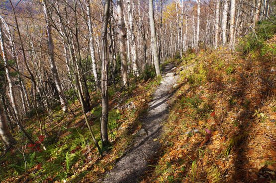
Part of the Unknown Pond Trail on October 15, 2014.
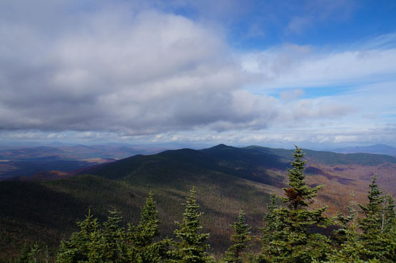
Views from The Horn on October 15, 2014.
Views from The Horn on October 15, 2014.
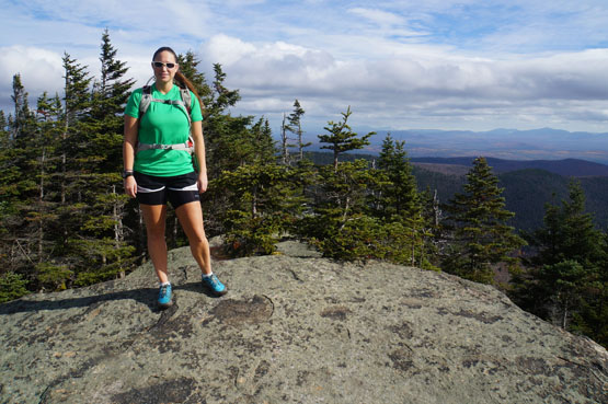
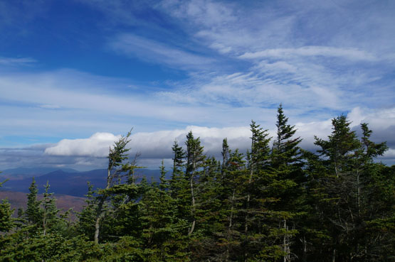
Summit of The Horn on October 15, 2014.
|
| The Horn Driving Directions for the Skyline Pond Traillhead |
Top |
The parking lot for the highlighted hike above is on the Berlin Fish Hatchery property, and the gates are open from 8:00am to 4:00pm. (but sometimes they do open it earlier for hikers or if they are there)
Take exit 35 off I-93 to merge onto US-3-N / Daniel Webster Highway towards Twin Mountain / Lancaster. Drive for 12.3 miles and turn right onto NH-115-N. Drive for 9.6 miles and turn right onto US-2 E / Presidential Highway. Drive 12.5 miles and turn left onto NH-16 N / Main Street. Drive 5 miles and turn left onto Green Street. Drive 0.3 miles and turn left onto 2nd Ave. Drive 463 feet and take your second left onto Madigan Street. Drive 374 feet and take your 1st right onto 3rd Avenue. Drive 0.2 miles and continue onto Wight Street. Drive 0.5 miles and continue onto NH-110 W / W Milan Road. Drive roughly 5 miles on York Pond Road, and stay right at the fork. Drive roughly 1.5 miles until you reach the parking lot on the right side of the road.
|
|
On this page: Information | Trail maps | View Photos | Driving Directions | Top
|
|
|
|
|
|
|
|
|
|
|
|
|
| |
| |
|
| New Hampshire 4,000 Footers |
Vermont + Maine 4,000 Footers |
Other Hiking Lists / Patches |
New England Mountain Ranges |
Stay Involved in New England |
New Hampshire
Mount Adams
Mount Bond
Bondcliff
Mount Bond, West Peak
Mount Cabot
Cannon Mountain
Mount Carrigain
Carter Dome
Carter, Middle
Carter, South
Mount Eisenhower
Mount Field
Mount Flume
Mount Galehead
Mount Garfield
Mount Hale
Mount Hancock
Mount Hancock, South Peak
Mount Isolation
Mount Jackson
Mount Jefferson
Mount Kinsman, North Peak
Mount Kinsman, South Peak
Mount Lafayette
Mount Liberty
Mount Lincoln
Mount Madison
Mount Monroe
Mount Moosilauke
Mount Moriah
Mount Osceola
Mount Osceola, East Peak
Owl's Head
Mount Passaconway
Mount Pierce
Mount Tecumseh
Mount Tom
Mount Tripyramid, Middle Peak
Mount Tripyramid, North Peak
Mount Twin, North Peak
Mount Twin, South Peak
Mount Washington
Mount Waumbek
Mount Whiteface
Mount Wildcat, A Peak
Mount Wildcat, D Peak
Mount Willey
Zealand Mountain |
Vermont
Mount Abraham
Camel's Hump
Mount Ellen
Killington Peak
Mount Mansfield
Maine
Mount Abraham
Mount Bigelow, Avery Peak
Mount Bigelow, West Peak
Crocker Mountain
Crocker Mountain, South
Mount Katahdin, Baxter Peak
Mount Katahdin, Hamlin Peak
North Brother Mountain
Old Speck Mountain
Mount Redington
Saddleback Mountain
Saddleback Mountain, The Horn
Spaulding Mountain
Sugarloaf Mountain |
NH 4,000 footers
NH 4,000 footers in Winter
New England 4,000 footers
NE 4,000 footers in Winter
NH Hundred Highest
New England Fifty Finest
52 With a view
Trailwrights 72 summit club
New England Hundred highest
NE Hundred highest in Winter
Northeast 111
48x12 "The Grid"
Red Lining
Belknap Range
LRCT / Castle in the Clouds
NH Fire Tower Quest
Hike by - Alphabetically
Hike by - Elevation
Hike by - Prominence
Hike by - Mountain Range |
Ranges in New Hampshire
View all NH mountain ranges
Baldface-Royce Range
Carter-Moriah Range
Dartmouth Range
Franconia Range
Kinsman Range
Mahoosuc
Range
Ossipee Mountains
Northern Ranges
Pemigewasset Wilderness
Pilot Range
Pliny Range
Presidential Range
Sandwich Range
Twin Range
Wapack Range
Western White Mountains
Willey Range
Ranges in Maine
View all ME mountain ranges
Baxter State Park
High Peaks
Bigelow Range
Eastern White Mountains
Ranges in Vermont
Green Mountains
Other VT mountain ranges |
NH Waterfalls
NH AMC Huts
Hiker's store |
New England 4,000 Footers | NH 4,000 Footers | VT 4,000 Footers | ME 4,000 Footers | Hiking Lists & Patches | Hiker's Store | Contact by email
© www.4000footers.com 2015. All rights reserved. We are not affiliated with the AMC or the AMC Four Thousand Footer Club |
|
|


