| New England 100 Highest List ↓ |
| Mount Abraham - Maine |
| Mount Abraham - Vermont |
| Mount Adams |
| Baldpate Mountain |
| Mount Bigelow, Avery Peak |
| Mount Bigelow, West Peak |
| Mount Bigelow, South Horn |
| Big Jay |
| Mount Bond |
| Bondcliff |
| Mount Bond, West Peak |
| Boundary Peak |
| Bread Loaf Mountain |
| Mount Cabot |
| Camel's Hump |
| Cannon Mountain |
| Cannon Ball, Northeast Peak |
| Mount Carrigain |
| Carter Dome |
| Carter, Middle |
| Carter, South |
| Mount Coe |
| Crocker Mountain |
| Crocker Mountain, South |
| Dorset Mountain |
| Mount Eisenhower |
| Elephant Mountain |
| Mount Ellen |
| Equinox Mountain |
| Mount Field |
| Mount Flume |
| Fort Mountain |
| Mount Galehead |
| Mount Garfield |
| Goose Eye Mountain |
| Mount Hale |
| Mount Hancock |
| Mount Hancock, South Peak |
| Mount Isolation |
| Mount Jackson |
| Jay Peak |
| Mount Jefferson |
| Mount Katahdin, Baxter Peak |
| Mount Katahdin, Hamlin Peak |
| Kennebago Divide |
| East Kennebago Mountain |
| Killington Peak |
| Mount Kinsman, North Peak |
| Mount Kinsman, South Peak |
| Mount Lafayette |
| Mount Liberty |
| Mount Lincoln |
| Mount Madison |
| Mount Mansfield |
| Mendon Peak |
| Mount Monroe |
| Mount Moosilauke |
| Mount Moriah |
| Mount Nancy |
| North Brother Mountain |
| Old Speck Mountain |
| Mount Osceola |
| Mount Osceola, East Peak |
| Owl's Head |
| Mount Passaconway |
| Peak Above the Nubble (PATN) |
| Pico Peak |
| Mount Pierce |
| Mount Redington |
| Saddleback Mountain |
| Saddleback Mountain, The Horn |
| Sandwich Mountain |
| Scar Ridge |
| Sleeper, East Peak |
| Snow Mountain - Franklin County |
| Snow Mountain - Oxford County |
| South Brother |
| Spauling Mountain |
| Stratton Mountain |
| Sugarloaf Mountain |
| Mount Tecumseh |
| The Bulge |
| The Horn |
| Mount Tom |
| Mount Tripyramid, Middle Peak |
| Mount Tripyramid, North Peak |
| Mount Twin, North Peak |
| Mount Twin, South Peak |
| Vose Spur |
| Mount Washington |
| Mount Waumbek |
| Mount Weeks |
| Mount Weeks, South |
| White Cap Mountain |
| Mount Whiteface |
| Mount Wildcat, A Peak |
| Mount Wildcat, D Peak |
| Mount Willey |
| Mount Wilson |
Zealand Mountain |
|
|
Hike Sandwich Dome / Sandwich Mountain |
| |
| On this page: Information | Trail maps | View Photos | Driving Directions |
| |
| Sandwich Mountain Information |
Elevation: 3,993 feet (1,215 meters)
Prominence:  1,200 feet (365 meters) 1,200 feet (365 meters)
Location: Sandwich, NH
Range: Sandwich Range
Coordinates: 43°54.02' North 71°29.89' West
Rating: Moderate (compared to a 4,000 footer)
Features: Can be a loop hike, Limited summit views, Peak bag , Drakes Brook water crossing
Distance of highlighted hike below: 8.6 miles with Jennings Peak and Noon Peak.
|
 |
Sandwich Mountain or Sandwich Dome as some call it, is a 3,993 foot mountain in Sandwich, NH in the White Mountains. It is located in the Sandwich Range. The mountain i flanked to the northeast by Mount Tripyramid and by Mount Weetamoo on the southwest.
You can peak bag Sandwich Dome along with Jennings Peak and Noon Peak by making a loop hike with the Sandwich Mountain Trail and the Drakes Brook Trail.
| For peak-baggers: |
Jennings Peak is 1.3 miles from the summit of Sandwich Mountain
Noon Peak is 1 mile from the summit of Sandwich Mountain
|
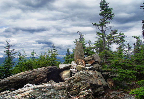
Photo taken from the summit of Sandwich Dome on 7-30-2014.
|
| Sandwich Dome Trail Maps |
Top |
The map below shows how to get to the summit of Sandwich Mountain as well as Jennings Peak and Noon Peak.
From the Sandwich Mountain Trail / Drakes Brook Trail Trailhead parking area on route 49, hike up the Sandwich Mountain Trail for 2.8 miles (going over Noon Peak). You will arrive at a junction with the Drakes Brook Trail on the left. If you hike on for a few more feet, you will come to a small junction with a spur trail on the right leading up to Jennings Peak. You can choose to hike up this 0.2 mile section to enjoy wonderful views on the peak or avoid it.
Continue along the Sandwich Mountain Trail for 1.1 miles (passing a junction with the Smarts Brook Trail at 0.5 miles) until you reach the summit of Sandwich Mountain.
To head back down to the parking lot retrace your steps for the last 1.1 miles on the Sandwich Mountain Trail until you come to the junction with the Drakes Brook Trail. Take the Drakes Brook Trail on the right for 3.2 miles until you reach the parking lot (you will pass a junction after 2.8 miles with Fletcher's Cascade Trail.)
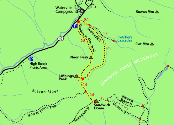
Click to download PDF Trail Map of Sandwich Dome / Sandwich Mountain
|
| |
| Sandwich Mountain Photos |
Top |
|
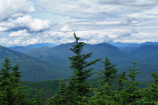
Views from the summit of Sandwich Mountain on 7-30-2014.
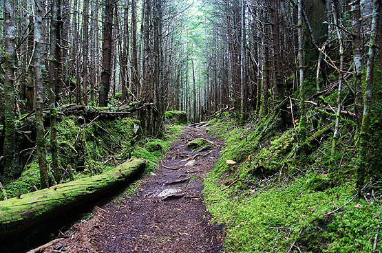
Along the Sandwich Mountain Trail on 7-30-2014.
|
| Sandwich Dome Driving Directions |
Top |
These are driving directions to the Drakes Brook / Sandwich Mountain Trailhead Parking lot
Take exit 28 off I-93 North onto NH49 towards NH 175 Campton / Waterville Valley. Drive 0.3 miles and turn right onto NH-49-East. (Route 49 is Valley Road). Drive roughly 10 miles until the small parking area on the right side of the road. If you reach the Waterville Campground or Tripoli Road (both on the left), you went too far.
If you have a GPS, you can put in Waterville Campground and just know to stop just short of that on Route 49 to the parking lot.
|
|
On this page: Information | Trail maps | View Photos | Driving Directions | Top
|
|
|
|
|
|
|
|
|
|
| |
|
|
|
| |
| New Hampshire 4,000 Footers |
Vermont + Maine 4,000 Footers |
Other Hiking Lists / Patches |
New England Mountain Ranges |
Stay Involved in New England |
New Hampshire
Mount Adams
Mount Bond
Bondcliff
Mount Bond, West Peak
Mount Cabot
Cannon Mountain
Mount Carrigain
Carter Dome
Carter, Middle
Carter, South
Mount Eisenhower
Mount Field
Mount Flume
Mount Galehead
Mount Garfield
Mount Hale
Mount Hancock
Mount Hancock, South Peak
Mount Isolation
Mount Jackson
Mount Jefferson
Mount Kinsman, North Peak
Mount Kinsman, South Peak
Mount Lafayette
Mount Liberty
Mount Lincoln
Mount Madison
Mount Monroe
Mount Moosilauke
Mount Moriah
Mount Osceola
Mount Osceola, East Peak
Owl's Head
Mount Passaconway
Mount Pierce
Mount Tecumseh
Mount Tom
Mount Tripyramid, Middle Peak
Mount Tripyramid, North Peak
Mount Twin, North Peak
Mount Twin, South Peak
Mount Washington
Mount Waumbek
Mount Whiteface
Mount Wildcat, A Peak
Mount Wildcat, D Peak
Mount Willey
Zealand Mountain |
Vermont
Mount Abraham
Camel's Hump
Mount Ellen
Killington Peak
Mount Mansfield
Maine
Mount Abraham
Mount Bigelow, Avery Peak
Mount Bigelow, West Peak
Crocker Mountain
Crocker Mountain, South
Mount Katahdin, Baxter Peak
Mount Katahdin, Hamlin Peak
North Brother Mountain
Old Speck Mountain
Mount Redington
Saddleback Mountain
Saddleback Mountain, The Horn
Spaulding Mountain
Sugarloaf Mountain |
NH 4,000 footers
NH 4,000 footers in Winter
New England 4,000 footers
NE 4,000 footers in Winter
NH Hundred Highest
New England Fifty Finest
52 With a view
Trailwrights 72 summit club
New England Hundred highest
NE Hundred highest in Winter
Northeast 111
48x12 "The Grid"
Red Lining
Belknap Range
LRCT / Castle in the Clouds
NH Fire Tower Quest
Hike by - Alphabetically
Hike by - Elevation
Hike by - Prominence
Hike by - Mountain Range |
Ranges in New Hampshire
View all NH mountain ranges
Baldface-Royce Range
Carter-Moriah Range
Dartmouth Range
Franconia Range
Kinsman Range
Mahoosuc
Range
Ossipee Mountains
Northern Ranges
Pemigewasset Wilderness
Pilot Range
Pliny Range
Presidential Range
Sandwich Range
Twin Range
Wapack Range
Western White Mountains
Willey Range
Ranges in Maine
View all ME mountain ranges
Baxter State Park
High Peaks
Bigelow Range
Eastern White Mountains
Ranges in Vermont
Green Mountains
Other VT mountain ranges |
NH Waterfalls
NH AMC Huts
Hiker's store |
New England 4,000 Footers | NH 4,000 Footers | VT 4,000 Footers | ME 4,000 Footers | Hiking Lists & Patches | Hiker's Store | Contact by email
© www.4000footers.com 2015. All rights reserved. We are not affiliated with the AMC or the AMC Four Thousand Footer Club |
|
|


