| New England 100 Highest List ↓ |
| Mount Abraham - Maine |
| Mount Abraham - Vermont |
| Mount Adams |
| Baldpate Mountain |
| Mount Bigelow, Avery Peak |
| Mount Bigelow, West Peak |
| Mount Bigelow, South Horn |
| Big Jay |
| Mount Bond |
| Bondcliff |
| Mount Bond, West Peak |
| Boundary Peak |
| Bread Loaf Mountain |
| Mount Cabot |
| Camel's Hump |
| Cannon Mountain |
| Cannon Ball, Northeast Peak |
| Mount Carrigain |
| Carter Dome |
| Carter, Middle |
| Carter, South |
| Mount Coe |
| Crocker Mountain |
| Crocker Mountain, South |
| Dorset Mountain |
| Mount Eisenhower |
| Elephant Mountain |
| Mount Ellen |
| Equinox Mountain |
| Mount Field |
| Mount Flume |
| Fort Mountain |
| Mount Galehead |
| Mount Garfield |
| Goose Eye Mountain |
| Mount Hale |
| Mount Hancock |
| Mount Hancock, South Peak |
| Mount Isolation |
| Mount Jackson |
| Jay Peak |
| Mount Jefferson |
| Mount Katahdin, Baxter Peak |
| Mount Katahdin, Hamlin Peak |
| Kennebago Divide |
| East Kennebago Mountain |
| Killington Peak |
| Mount Kinsman, North Peak |
| Mount Kinsman, South Peak |
| Mount Lafayette |
| Mount Liberty |
| Mount Lincoln |
| Mount Madison |
| Mount Mansfield |
| Mendon Peak |
| Mount Monroe |
| Mount Moosilauke |
| Mount Moriah |
| Mount Nancy |
| North Brother Mountain |
| Old Speck Mountain |
| Mount Osceola |
| Mount Osceola, East Peak |
| Owl's Head |
| Mount Passaconway |
| Peak Above the Nubble (PATN) |
| Pico Peak |
| Mount Pierce |
| Mount Redington |
| Saddleback Mountain |
| Saddleback Mountain, The Horn |
| Sandwich Mountain |
| Scar Ridge |
| Sleeper, East Peak |
| Snow Mountain - Franklin County |
| Snow Mountain - Oxford County |
| South Brother |
| Spauling Mountain |
| Stratton Mountain |
| Sugarloaf Mountain |
| Mount Tecumseh |
| The Bulge |
| The Horn |
| Mount Tom |
| Mount Tripyramid, Middle Peak |
| Mount Tripyramid, North Peak |
| Mount Twin, North Peak |
| Mount Twin, South Peak |
| Vose Spur |
| Mount Washington |
| Mount Waumbek |
| Mount Weeks |
| Mount Weeks, South |
| White Cap Mountain |
| Mount Whiteface |
| Mount Wildcat, A Peak |
| Mount Wildcat, D Peak |
| Mount Willey |
| Mount Wilson |
Zealand Mountain |
|
|
Hike East Sleeper (Part of The Sleepers) |
| |
| On this page: Information | Trail maps | View Photos | Driving Directions |
| |
Elevation: 3,840 feet (1,170 meters)
Prominence:  180 feet (55 meters) 180 feet (55 meters)
Location: Waterville Valley, New Hampshire (Grafton County)
Range: Sandwich Range
Coordinates: 43°56.80' North 71°25.53' West
Rating: Difficult
Features: New England Hundred highest, and New Hampshire Hundred highest, many river crossings
Distance of highlighted hike below: Roughly 12.2 miles via the Downes Brook Trail off Route 112 (Kancamagus Highway)
|
 |
East Sleeper is one of two peaks known as The Sleepers, with West Sleeper (3,881'). East Sleeper 3,840 feet tall and sits in the Sandwich Range in the White Mountains of New Hampshire.
The Sleepers are flanked to the Northwest by Middle Tripyramid, to the Northeast by Mount Passaconway, and to the Southeast by Mount Whiteface.
The sleepers got its name from a local innkeeper named Katherine Sleeper, who was a big part of trail development in the area. The Kate Sleeper Trail, which both Sleeper peaks are off of, is named after her as well.
Even though West Sleeper Mountain is taller than East Sleeper, only the East peak is on the New England Hundred highest hiking list, because the dip between West Sleeper and South Tripyramid Mountain is under the 200 foot requirement for the list.
|
| East Sleeper Trail Maps - Directions from the parking lot to the summit |
Top |
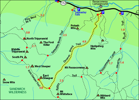
The map below shows how to get to the summit via the Downes Brook Trail. You can hike this from Mount Whiteface as well. Click here to see the Whiteface map.
From the parking area hike to the Downes Brook Trail. There is a short 0.3 mile segment right from the parking lot. After that continue on the Downes Brook Trail by forking left. (Right will take you up to Potash Mountain). Hike for another 4.9 miles following the Downes Brook most of the way with several crossings. After the 4.9 miles you will come to a junction with the Blueberry Ledge Trail on the left and the Kate Sleeper Trail on the right. Go right on the Kate Sleeper Trail and hike for roughly 0.8 miles until you come to a spur trail on the right that leads to the summit of East Sleeper.
To get back to the parking lot, retrace your steps the way you came. (Or you can make a loop and continue along the Kate Sleeper Trail and passing over South Tripyramid Mountain and Middle Tripyramid Mountain and descending the Sabbaday Brook Trail. You would then have to walk on Route 112 for roughly a mile before turning right onto the side road the parking lot is on.)
Click to download PDF Trail Map of East Sleeper
You can also hike East Sleeper from Ferncroft Road and hike Mount Whiteface first. See map.
|
| |
|
| |
| East Sleeper View Photos |
Top |
|
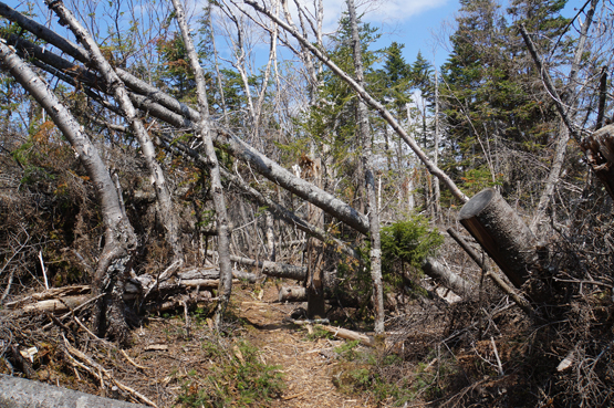
Kate Sleeper Trail in rough condition on May 24, 2015.
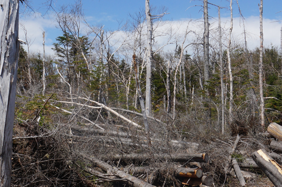
Kate Sleeper Trail in rough condition on May 24, 2015.
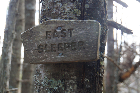
Summit of East Sleeper on May 24, 2015.
|
| East Sleeper Driving Directions |
Top |
The parking area for the highlighted hike above is located off the Kancamagus Highway, Route 112. (To hike East Sleeper from Mount Whiteface, click here to see the Whiteface page with directions.)
From I-93 North, take exit 32 for NH-112 for Woodstock.
Turn left onto Route 112 / Kancamagus Highway.
Drive roughly 21 miles and turn right onto a side road where there is a parking area at the end.
|
|
On this page: Information | Trail maps | View Photos | Driving Directions | Top
|
|
|
|
|
|
|
|
|
|
|
|
|
| |
| |
|
| New Hampshire 4,000 Footers |
Vermont + Maine 4,000 Footers |
Other Hiking Lists / Patches |
New England Mountain Ranges |
Stay Involved in New England |
New Hampshire
Mount Adams
Mount Bond
Bondcliff
Mount Bond, West Peak
Mount Cabot
Cannon Mountain
Mount Carrigain
Carter Dome
Carter, Middle
Carter, South
Mount Eisenhower
Mount Field
Mount Flume
Mount Galehead
Mount Garfield
Mount Hale
Mount Hancock
Mount Hancock, South Peak
Mount Isolation
Mount Jackson
Mount Jefferson
Mount Kinsman, North Peak
Mount Kinsman, South Peak
Mount Lafayette
Mount Liberty
Mount Lincoln
Mount Madison
Mount Monroe
Mount Moosilauke
Mount Moriah
Mount Osceola
Mount Osceola, East Peak
Owl's Head
Mount Passaconway
Mount Pierce
Mount Tecumseh
Mount Tom
Mount Tripyramid, Middle Peak
Mount Tripyramid, North Peak
Mount Twin, North Peak
Mount Twin, South Peak
Mount Washington
Mount Waumbek
Mount Whiteface
Mount Wildcat, A Peak
Mount Wildcat, D Peak
Mount Willey
Zealand Mountain |
Vermont
Mount Abraham
Camel's Hump
Mount Ellen
Killington Peak
Mount Mansfield
Maine
Mount Abraham
Mount Bigelow, Avery Peak
Mount Bigelow, West Peak
Crocker Mountain
Crocker Mountain, South
Mount Katahdin, Baxter Peak
Mount Katahdin, Hamlin Peak
North Brother Mountain
Old Speck Mountain
Mount Redington
Saddleback Mountain
Saddleback Mountain, The Horn
Spaulding Mountain
Sugarloaf Mountain |
NH 4,000 footers
NH 4,000 footers in Winter
New England 4,000 footers
NE 4,000 footers in Winter
NH Hundred Highest
New England Fifty Finest
52 With a view
Trailwrights 72 summit club
New England Hundred highest
NE Hundred highest in Winter
Northeast 111
48x12 "The Grid"
Red Lining
Belknap Range
LRCT / Castle in the Clouds
NH Fire Tower Quest
Hike by - Alphabetically
Hike by - Elevation
Hike by - Prominence
Hike by - Mountain Range |
Ranges in New Hampshire
View all NH mountain ranges
Baldface-Royce Range
Carter-Moriah Range
Dartmouth Range
Franconia Range
Kinsman Range
Mahoosuc
Range
Ossipee Mountains
Northern Ranges
Pemigewasset Wilderness
Pilot Range
Pliny Range
Presidential Range
Sandwich Range
Twin Range
Wapack Range
Western White Mountains
Willey Range
Ranges in Maine
View all ME mountain ranges
Baxter State Park
High Peaks
Bigelow Range
Eastern White Mountains
Ranges in Vermont
Green Mountains
Other VT mountain ranges |
NH Waterfalls
NH AMC Huts
Hiker's store |
New England 4,000 Footers | NH 4,000 Footers | VT 4,000 Footers | ME 4,000 Footers | Hiking Lists & Patches | Hiker's Store | Contact by email
© www.4000footers.com 2015. All rights reserved. We are not affiliated with the AMC or the AMC Four Thousand Footer Club |
|
|


