| New England 100 Highest List ↓ |
| Mount Abraham - Maine |
| Mount Abraham - Vermont |
| Mount Adams |
| Baldpate Mountain |
| Mount Bigelow, Avery Peak |
| Mount Bigelow, West Peak |
| Mount Bigelow, South Horn |
| Big Jay |
| Mount Bond |
| Bondcliff |
| Mount Bond, West Peak |
| Boundary Peak |
| Bread Loaf Mountain |
| Mount Cabot |
| Camel's Hump |
| Cannon Mountain |
| Cannon Ball, Northeast Peak |
| Mount Carrigain |
| Carter Dome |
| Carter, Middle |
| Carter, South |
| Mount Coe |
| Crocker Mountain |
| Crocker Mountain, South |
| Dorset Mountain |
| Mount Eisenhower |
| Elephant Mountain |
| Mount Ellen |
| Equinox Mountain |
| Mount Field |
| Mount Flume |
| Fort Mountain |
| Mount Galehead |
| Mount Garfield |
| Goose Eye Mountain |
| Mount Hale |
| Mount Hancock |
| Mount Hancock, South Peak |
| Mount Isolation |
| Mount Jackson |
| Jay Peak |
| Mount Jefferson |
| Mount Katahdin, Baxter Peak |
| Mount Katahdin, Hamlin Peak |
| Kennebago Divide |
| East Kennebago Mountain |
| Killington Peak |
| Mount Kinsman, North Peak |
| Mount Kinsman, South Peak |
| Mount Lafayette |
| Mount Liberty |
| Mount Lincoln |
| Mount Madison |
| Mount Mansfield |
| Mendon Peak |
| Mount Monroe |
| Mount Moosilauke |
| Mount Moriah |
| Mount Nancy |
| North Brother Mountain |
| Old Speck Mountain |
| Mount Osceola |
| Mount Osceola, East Peak |
| Owl's Head |
| Mount Passaconway |
| Peak Above the Nubble (PATN) |
| Pico Peak |
| Mount Pierce |
| Mount Redington |
| Saddleback Mountain |
| Saddleback Mountain, The Horn |
| Sandwich Mountain |
| Scar Ridge |
| Sleeper, East Peak |
| Snow Mountain - Franklin County |
| Snow Mountain - Oxford County |
| South Brother |
| Spauling Mountain |
| Stratton Mountain |
| Sugarloaf Mountain |
| Mount Tecumseh |
| The Bulge |
| The Horn |
| Mount Tom |
| Mount Tripyramid, Middle Peak |
| Mount Tripyramid, North Peak |
| Mount Twin, North Peak |
| Mount Twin, South Peak |
| Vose Spur |
| Mount Washington |
| Mount Waumbek |
| Mount Weeks |
| Mount Weeks, South |
| White Cap Mountain |
| Mount Whiteface |
| Mount Wildcat, A Peak |
| Mount Wildcat, D Peak |
| Mount Willey |
| Mount Wilson |
Zealand Mountain |
|
|
Hike Jay Peak (and Big Jay) |
| |
| On this page: Information | Trail maps | View Photos | Driving Directions |
| |
Elevation: 3,858 feet (1,176 meters)
Prominence:  2,952 feet (900 meters) 2,952 feet (900 meters)
Location: Westfield and Jay, Vermont
Range: Green Mountains
Coordinates: 44°55'27" North 72°31'32" West
Rating: Easy/Moderate - The hike up the Long Trail to Jay Peak is a steady low incline hike with small rock scrambles the last 0.4 miles. The hike over to Big Jay is via a well-defined herd path.
Features: Atlas Valley Shelter, Long Trail, Jay Peak summit house (with restrooms and hot food available!), herd path, Jay Peak State Forest, New England Hundred highest, New England Fifty Finest
Distance of highlighted hike below: Roughly 6 miles with Big Jay
|
 |
Jay Peak is 3,858 foot mountain in the Green Mountains of beautiful Vermont in Jay Peak State Forest. It is the highest point in Orleans County, Vermont.
Jay Peak is most known for its ski area; Jay Peak Ski Area. When hiking, you might come across more people than expected at the summit from tourists riding the gondola up the mountain and catching the views. When at the summit, you may notice rock slabs that have clearly been cut into; this is because the original summit used to be higher until construction began on the summit to build the Tram Haus. The summit rocks had to be flattened a bit to fit the building.
The mountain is flanked to the Southwest by Big Jay, and to the North by North Jay Peak. Jay Peak is the Northernmost major mountain crossed by the Long Trail, which spans the length of the state of Vermont.
|
| Jay Peak Trail Maps - Directions from the parking lot to the summit |
Top |
The map below shows how to get to the summit of Jay Peak and Big Jay. (Note: This hike involves a herd path to get to Big Jay's summit, which is an unmaintained path in the woods.)
(NOTE - THERE IS NO MAINTAINED TRAIL TO THE SUMMIT OF BIG JAY; ONLY A HERD PATH)
From the parking area on Route 242, the trail starts across the street. It can be kind of hard to see where it begins if the brush is thick. Hike up the Long Trail for 1.7 miles until you reach the summit of Jay Peak. The trail from route 242 is a nice low steady incline and has rock scrambles roughly the last 0.4 miles. Before you get to the summit, you will go up and down a stairwell. Here you can choose to continue on the Long trail, in which case you will walk straight across the wide ski trail and look for the white blazes on the rocks and rock scramble to the summit, or you can go left on the wide path until you reach the summit building. The summit is all bare rocks and there is a building that offers cooked food, beverages with plenty of seating and restrooms.
To continue over to Big Jay, there is a stairwell outside of the summit building. Go down those stairs and walk towards the right down a wide ski path, which is the Long Trail. There will be a few white blazes on rocks on the ground. (If you are hiking in the Winter and won't be able to see any blazes on the ground, the trail is the one directly behind the summit building). You will pass a sign on your right for the Tuckerman's Trail (see photo below). Continue on the wide trail down the hill until you see a fence directly in front of you. Go a few steps to the right and you will see an opening in the fence. (see photo below). The herd path to the summit of Big Jay begins right behind this fence. The path is pretty obvious the entire way with only a few short sections of thick brush. This herd path is known for being MUD CENTRAIL! The mud can be well over a foot deep in areas, so gaiters are a good idea. The summit has a red sled, a summit sign and a small jar hanging on a tree (on a herd path behind the red sled to the left). [all there as of October 2014.]
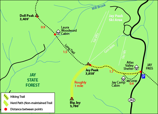
Click to download PDF Trail Map of Jay Peak and Big Jay
|
| |
|
| |
|
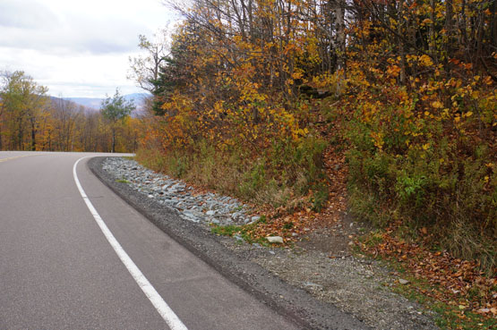
Beginning of the Long Trail on the opposite side of the parking area on Route 242. Taken on 10/9/14.
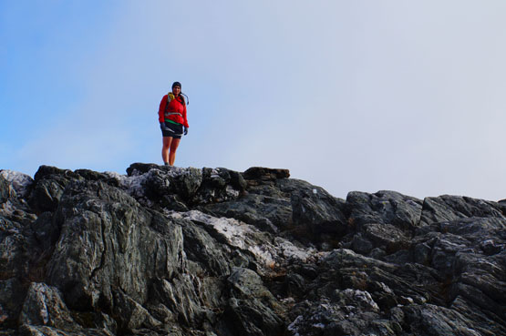
Summit of Jay Peak. Taken on 10/9/14.
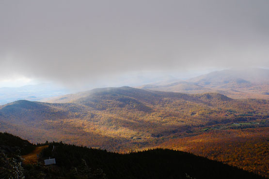
Views near the summit of Jay Peak. Taken on 10/9/14.
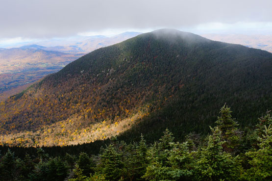
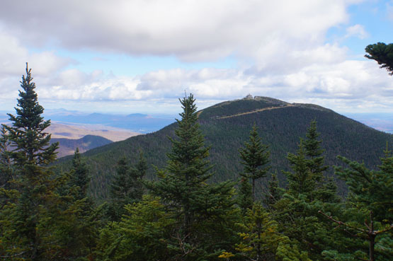
Looking at Big Jay Mountain from the summit of Jay Peak. Taken on 10/9/14.
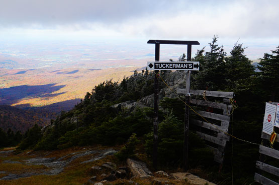
To get over to Big Jay, You will walk down the Long Trail passing this Tuckerman's sign on your right.
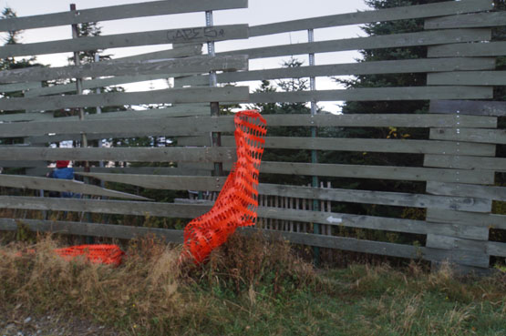
While walking down the wide Long Trail section of trail you will see a fence straight ahead of you down a hill. Look to the right and you will see this opening in the fence - the start of the herd path over to Big Jay starts on the other side of the fence.
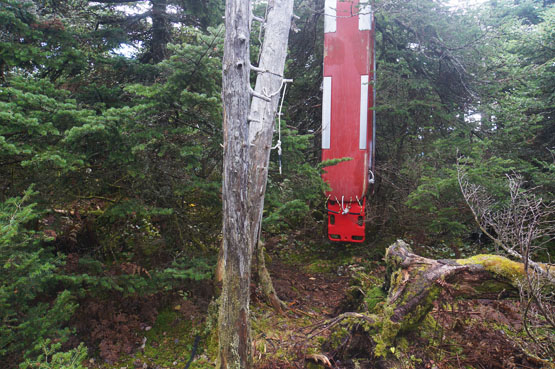
This is the summit area of Big Jay with the famous red sled hanging in a tree. There was no canister on 10/9/14, but the bracket where it used to be was there.
Looking at Jay Peak from the herd path on Big Jay on 10/9/2014.
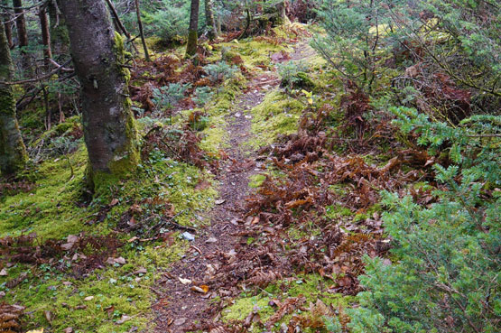
The herd path between Jay Peak and Big Jay mountain is obvious the entire way with only a few small sections of thick brush.
|
| Jay Peak Driving Directions |
Top |
The parking area for the highlighted hike above is located on the side of Route 242 in Westfield, Vermont.
From I-93 North, take the exit for I-91 towards St.Johnsbury. Drive 33 miles and take exit 26 off I-91 to Route 5 West. Drive 5.7 miles and turn left onto Route 14 / Route 105. Drive 4.8 miles and continue onto Vermont 100 South. Drive 5.7 miles and take a slight right onto South Pleasant Street. (Corner of Troy General Store). Take a quick first right onto Vermont 101 North. Drive 3.1 miles and turn left onto Route 242 West. Drive roughly 6.5 miles until you see a wider section of the road on your left where you can park. The trail up to Jay Peak starts across the street up a hill.
If you have a GPS, you can enter Jay Peak Ski Area (830 Jay Peak Road in Jay Vermont) and when you are still on 242, instead of turning onto Jay Peak Road to the ski area, stay on Route 242 for roughly 2-3 miles to the parking area on the left side of the road.
|
|
On this page: Information | Trail maps | View Photos | Driving Directions | Top
|
|
|
|
|
|
|
|
|
|
|
|
|
| |
| |
|
| New Hampshire 4,000 Footers |
Vermont + Maine 4,000 Footers |
Other Hiking Lists / Patches |
New England Mountain Ranges |
Stay Involved in New England |
New Hampshire
Mount Adams
Mount Bond
Bondcliff
Mount Bond, West Peak
Mount Cabot
Cannon Mountain
Mount Carrigain
Carter Dome
Carter, Middle
Carter, South
Mount Eisenhower
Mount Field
Mount Flume
Mount Galehead
Mount Garfield
Mount Hale
Mount Hancock
Mount Hancock, South Peak
Mount Isolation
Mount Jackson
Mount Jefferson
Mount Kinsman, North Peak
Mount Kinsman, South Peak
Mount Lafayette
Mount Liberty
Mount Lincoln
Mount Madison
Mount Monroe
Mount Moosilauke
Mount Moriah
Mount Osceola
Mount Osceola, East Peak
Owl's Head
Mount Passaconway
Mount Pierce
Mount Tecumseh
Mount Tom
Mount Tripyramid, Middle Peak
Mount Tripyramid, North Peak
Mount Twin, North Peak
Mount Twin, South Peak
Mount Washington
Mount Waumbek
Mount Whiteface
Mount Wildcat, A Peak
Mount Wildcat, D Peak
Mount Willey
Zealand Mountain |
Vermont
Mount Abraham
Camel's Hump
Mount Ellen
Killington Peak
Mount Mansfield
Maine
Mount Abraham
Mount Bigelow, Avery Peak
Mount Bigelow, West Peak
Crocker Mountain
Crocker Mountain, South
Mount Katahdin, Baxter Peak
Mount Katahdin, Hamlin Peak
North Brother Mountain
Old Speck Mountain
Mount Redington
Saddleback Mountain
Saddleback Mountain, The Horn
Spaulding Mountain
Sugarloaf Mountain |
NH 4,000 footers
NH 4,000 footers in Winter
New England 4,000 footers
NE 4,000 footers in Winter
NH Hundred Highest
New England Fifty Finest
52 With a view
Trailwrights 72 summit club
New England Hundred highest
NE Hundred highest in Winter
Northeast 111
48x12 "The Grid"
Red Lining
Belknap Range
LRCT / Castle in the Clouds
NH Fire Tower Quest
Hike by - Alphabetically
Hike by - Elevation
Hike by - Prominence
Hike by - Mountain Range |
Ranges in New Hampshire
View all NH mountain ranges
Baldface-Royce Range
Carter-Moriah Range
Dartmouth Range
Franconia Range
Kinsman Range
Mahoosuc
Range
Ossipee Mountains
Northern Ranges
Pemigewasset Wilderness
Pilot Range
Pliny Range
Presidential Range
Sandwich Range
Twin Range
Wapack Range
Western White Mountains
Willey Range
Ranges in Maine
View all ME mountain ranges
Baxter State Park
High Peaks
Bigelow Range
Eastern White Mountains
Ranges in Vermont
Green Mountains
Other VT mountain ranges |
NH Waterfalls
NH AMC Huts
Hiker's store |
New England 4,000 Footers | NH 4,000 Footers | VT 4,000 Footers | ME 4,000 Footers | Hiking Lists & Patches | Hiker's Store | Contact by email
© www.4000footers.com 2015. All rights reserved. We are not affiliated with the AMC or the AMC Four Thousand Footer Club |
|
|


