| New England 100 Highest List ↓ |
| Mount Abraham - Maine |
| Mount Abraham - Vermont |
| Mount Adams |
| Baldpate Mountain |
| Mount Bigelow, Avery Peak |
| Mount Bigelow, West Peak |
| Mount Bigelow, South Horn |
| Big Jay |
| Mount Bond |
| Bondcliff |
| Mount Bond, West Peak |
| Boundary Peak |
| Bread Loaf Mountain |
| Mount Cabot |
| Camel's Hump |
| Cannon Mountain |
| Cannon Ball, Northeast Peak |
| Mount Carrigain |
| Carter Dome |
| Carter, Middle |
| Carter, South |
| Mount Coe |
| Crocker Mountain |
| Crocker Mountain, South |
| Dorset Mountain |
| Mount Eisenhower |
| Elephant Mountain |
| Mount Ellen |
| Equinox Mountain |
| Mount Field |
| Mount Flume |
| Fort Mountain |
| Mount Galehead |
| Mount Garfield |
| Goose Eye Mountain |
| Mount Hale |
| Mount Hancock |
| Mount Hancock, South Peak |
| Mount Isolation |
| Mount Jackson |
| Jay Peak |
| Mount Jefferson |
| Mount Katahdin, Baxter Peak |
| Mount Katahdin, Hamlin Peak |
| Kennebago Divide |
| East Kennebago Mountain |
| Killington Peak |
| Mount Kinsman, North Peak |
| Mount Kinsman, South Peak |
| Mount Lafayette |
| Mount Liberty |
| Mount Lincoln |
| Mount Madison |
| Mount Mansfield |
| Mendon Peak |
| Mount Monroe |
| Mount Moosilauke |
| Mount Moriah |
| Mount Nancy |
| North Brother Mountain |
| Old Speck Mountain |
| Mount Osceola |
| Mount Osceola, East Peak |
| Owl's Head |
| Mount Passaconway |
| Peak Above the Nubble (PATN) |
| Pico Peak |
| Mount Pierce |
| Mount Redington |
| Saddleback Mountain |
| Saddleback Mountain, The Horn |
| Sandwich Mountain |
| Scar Ridge |
| Sleeper, East Peak |
| Snow Mountain - Franklin County |
| Snow Mountain - Oxford County |
| South Brother |
| Spauling Mountain |
| Stratton Mountain |
| Sugarloaf Mountain |
| Mount Tecumseh |
| The Bulge |
| The Horn |
| Mount Tom |
| Mount Tripyramid, Middle Peak |
| Mount Tripyramid, North Peak |
| Mount Twin, North Peak |
| Mount Twin, South Peak |
| Vose Spur |
| Mount Washington |
| Mount Waumbek |
| Mount Weeks |
| Mount Weeks, South |
| White Cap Mountain |
| Mount Whiteface |
| Mount Wildcat, A Peak |
| Mount Wildcat, D Peak |
| Mount Willey |
| Mount Wilson |
Zealand Mountain |
|
|
Hike / Bushwhack to Elephant Mountain |
| |
| On this page: Information | Trail maps | View Photos | Driving Directions |
| |
| Elephant Mountain Information |
Elevation: 3,772 feet (1,150 meters)
Prominence:  2,060 feet (630 meters) 2,060 feet (630 meters)
Location: Andover (Township C), Maine (Oxford, County)
Coordinates: 44°46'05" North 70°46'54" West
Rating: Difficult due to the fact that there is no trail to the summit. But, on the other hand, for a bushwhack, this hike is relatively easy following an old logging road part of the way, and some herd path with little elevation gain. It usually takes roughly 3 hours up and back.
Features: Bushwhack, Old logging roads, some herd path
Elevation Gain: 1,140 feet
Distance of highlighted hike below: Roughly 2.5 miles round trip (Depends on your bushwhack route though)
|
 |
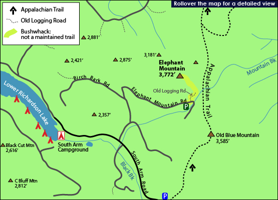
Elephant Mountain is a 3,772 foot mountain located in Andover, Maine in Oxford County, not to be confused with the other Elephant Mountain in Piscataquis County, Maine that stands at 2,650 feet tall.
Elephant Mountain is flanked to the Northeast by Bemis Mountain (3,581 feet) and to the Southeast by Old Blue Mountain (3,585 feet).
The Appalachian Trail runs along the base of Elephant Mountain and crosses over Elephant Mountain Road in Andover (Township C), Maine, which you can see when driving to the parking area to hike Elephant Mountain.
There is no trail to the summit of Elephant Mountain, so the only way to reach the summit is via a bushwhack. There are some herd paths to be seen on the mountain, and most people opt to begin on an old logging road at the end of Elephant Mountain Road.
|
| Elephant Mountain Trail Maps - Directions from the parking lot to the summit |
Top |
The map below shows a suggested idea of how to get to the summit of Elephant Mountain. (Since there are no trails to the summit, you must bushwhack, so the map below is no an exact route.)
(NOTE: THIS IS A BUSHWHACK HIKE. THERE IS NO MAINTAINED TRAIL TO THE SUMMIT OF ELEPHANT MOUNTAIN, SO ONLY ATTEMPT THIS IF YOU ARE SMART WITH A NAVIGATION SYSTEM AND/OR KNOW WHAT YOU ARE DOING.)
From the parking area (see driving directions below), hike up the hill that goes slightly left. This rough road is a continuation of Elephant Mountain Road. Hike on this old road until you come to an open field (see photo below). Walk across this field, aiming towards the left side. There is a cairn marking where to turn in the back left of the field. Turn left at the cairn. (You might see some colored tape [blue, yellow, orange] on some trees. Don't follow these. These are most likely used by hunters).
You might come to a marshy area. Most people opt to go across and to the right past it, still on somewhat of a path. You will soon find yourself in thicker brush for a short while, but the higher up you get, the more of a herd path you will see. The herd path is well defined the closer you get to the summit.
Click to download PDF Trail Map of Elephant Mountain.
|
| |
|
| |
 |
| |
| |
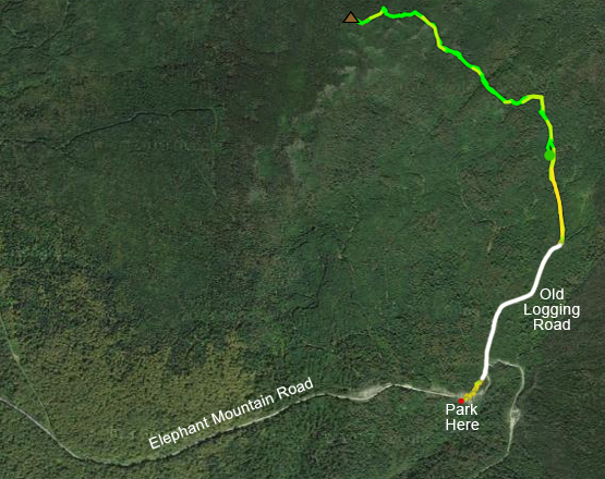
Approximate bushwhack route to Elephant Mountain. The white is an old logging road. The yellow/green is a bushwhack route a hiker took. |
| |
| |
| Elephant Mountain View Photos |
Top |
|
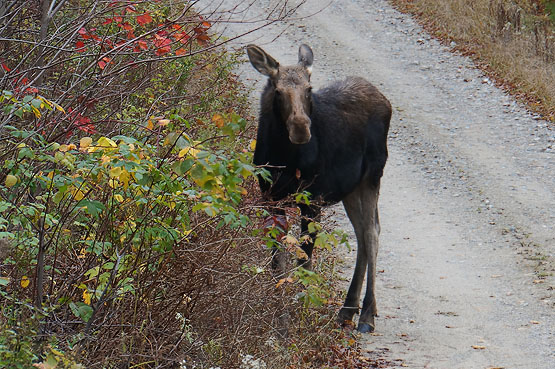
Moose on Elephant Mountain Road on October 19, 2014.
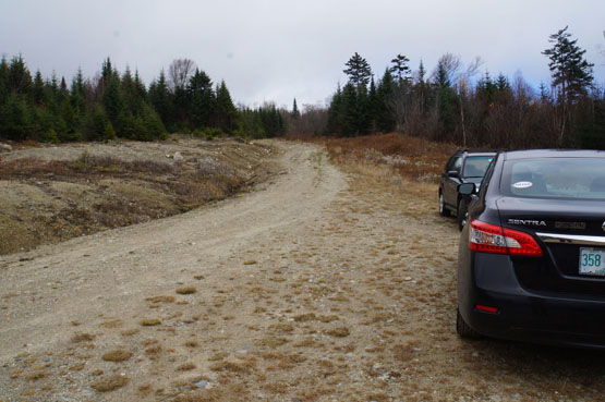
The parking area on Elephant Mountain Road on October 19, 2014. (just before the hill that goes up to the left).
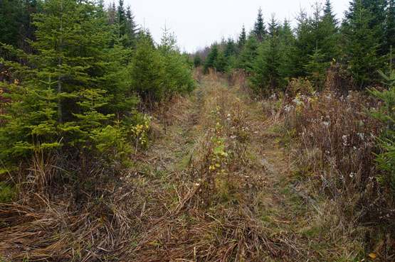
The old logging road is easy to see October 19, 2014.
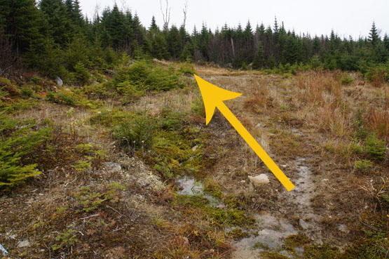
The field you will see after hiking on the logging road. The arrow is pointing to a cairn that you can't see in the photo, but indicates to turn left once you reach it. On October 19, 2014.
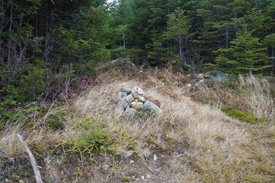
A close-up of that cairn. On October 19, 2014.
Thick parts of the bushwhack up to Elephant Mountain, on October 19, 2014.
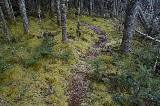
Some very well-defined herd path close to the summit of Elephant Mountain. On October 19, 2014.
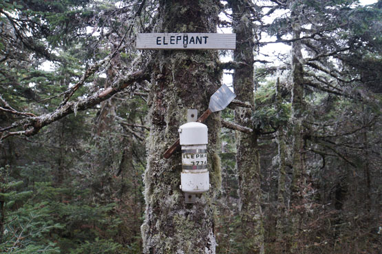
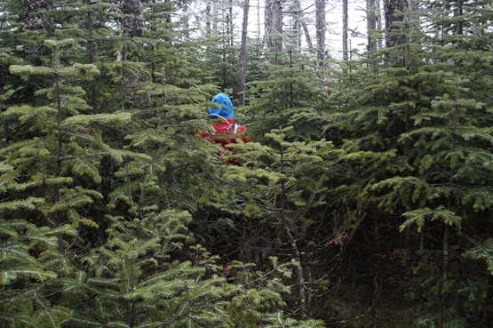
Summit canister and sign (and spatula!) on Elephant Mountain. On October 19, 2014.
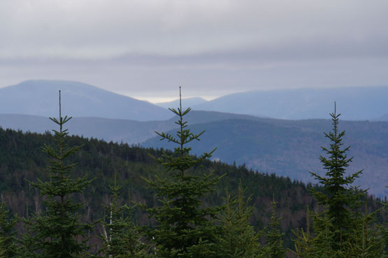
Some views from the old logging road. On October 19, 2014.
|
| Elephant Mountain Driving Directions |
Top |
If you have a GPS, you can enter Elephant Mountain Road in Andover, Maine. This is a rocky dirt road [and has no street sign as of October 2014]. Bear left at roughly 0.4 miles. Then turn right in another 0.7 miles. Roughly 3 miles from South Arm Road the road will dip down - this is where you park (it is right before a hill that curves to the left. See photo above.)
From the South: Follow Route 5 to its Northern Terminus in Andover, Maine and turn right (East) onto Route 120. Quickly cross a bridge over the Ellis River and turn left (North) onto South Arm Road, about 0.6 miles from the intersection of 5 and 120. Continue North on South Arm Road for just about 10 miles. (You will pass the Appalachian Trail crossing at roughly 7.5 miles - but you may miss it, because it is not well marked). After crossing Clear Water Brook turn right onto Elephant Mountain Road. This is a rocky dirt road [and has no street sign as of October 2014]. Bear left at roughly 0.4 miles. Then turn right in another 0.7 miles. Roughly 3 miles from South Arm Road the road will dip down - this is where you park (it is right before a hill that curves to the left. See photo above.)
|
|
| |
On this page: Information | Trail maps | View Photos | Driving Directions | Top
|
|
|
|
|
|
| |
|
|
|
|
|
| |
|
| New Hampshire 4,000 Footers |
Vermont + Maine 4,000 Footers |
Other Hiking Lists / Patches |
New England Mountain Ranges |
Stay Involved in New England |
New Hampshire
Mount Adams
Mount Bond
Bondcliff
Mount Bond, West Peak
Mount Cabot
Cannon Mountain
Mount Carrigain
Carter Dome
Carter, Middle
Carter, South
Mount Eisenhower
Mount Field
Mount Flume
Mount Galehead
Mount Garfield
Mount Hale
Mount Hancock
Mount Hancock, South Peak
Mount Isolation
Mount Jackson
Mount Jefferson
Mount Kinsman, North Peak
Mount Kinsman, South Peak
Mount Lafayette
Mount Liberty
Mount Lincoln
Mount Madison
Mount Monroe
Mount Moosilauke
Mount Moriah
Mount Osceola
Mount Osceola, East Peak
Owl's Head
Mount Passaconway
Mount Pierce
Mount Tecumseh
Mount Tom
Mount Tripyramid, Middle Peak
Mount Tripyramid, North Peak
Mount Twin, North Peak
Mount Twin, South Peak
Mount Washington
Mount Waumbek
Mount Whiteface
Mount Wildcat, A Peak
Mount Wildcat, D Peak
Mount Willey
Zealand Mountain |
Vermont
Mount Abraham
Camel's Hump
Mount Ellen
Killington Peak
Mount Mansfield
Maine
Mount Abraham
Mount Bigelow, Avery Peak
Mount Bigelow, West Peak
Crocker Mountain
Crocker Mountain, South
Mount Katahdin, Baxter Peak
Mount Katahdin, Hamlin Peak
North Brother Mountain
Old Speck Mountain
Mount Redington
Saddleback Mountain
Saddleback Mountain, The Horn
Spaulding Mountain
Sugarloaf Mountain |
NH 4,000 footers
NH 4,000 footers in Winter
New England 4,000 footers
NE 4,000 footers in Winter
NH Hundred Highest
New England Fifty Finest
52 With a view
Trailwrights 72 summit club
New England Hundred highest
NE Hundred highest in Winter
Northeast 111
48x12 "The Grid"
Red Lining
Belknap Range
LRCT / Castle in the Clouds
NH Fire Tower Quest
Hike by - Alphabetically
Hike by - Elevation
Hike by - Prominence
Hike by - Mountain Range |
Ranges in New Hampshire
View all NH mountain ranges
Baldface-Royce Range
Carter-Moriah Range
Dartmouth Range
Franconia Range
Kinsman Range
Mahoosuc
Range
Ossipee Mountains
Northern Ranges
Pemigewasset Wilderness
Pilot Range
Pliny Range
Presidential Range
Sandwich Range
Twin Range
Wapack Range
Western White Mountains
Willey Range
Ranges in Maine
View all ME mountain ranges
Baxter State Park
High Peaks
Bigelow Range
Eastern White Mountains
Ranges in Vermont
Green Mountains
Other VT mountain ranges |
NH Waterfalls
NH AMC Huts
Hiker's store |
New England 4,000 Footers | NH 4,000 Footers | VT 4,000 Footers | ME 4,000 Footers | Hiking Lists & Patches | Hiker's Store | Contact by email
© www.4000footers.com 2015. All rights reserved. We are not affiliated with the AMC or the AMC Four Thousand Footer Club |
|
|


