| New England 100 Highest List ↓ |
| Mount Abraham - Maine |
| Mount Abraham - Vermont |
| Mount Adams |
| Baldpate Mountain |
| Mount Bigelow, Avery Peak |
| Mount Bigelow, West Peak |
| Mount Bigelow, South Horn |
| Big Jay |
| Mount Bond |
| Bondcliff |
| Mount Bond, West Peak |
| Boundary Peak |
| Bread Loaf Mountain |
| Mount Cabot |
| Camel's Hump |
| Cannon Mountain |
| Cannon Ball, Northeast Peak |
| Mount Carrigain |
| Carter Dome |
| Carter, Middle |
| Carter, South |
| Mount Coe |
| Crocker Mountain |
| Crocker Mountain, South |
| Dorset Mountain |
| Mount Eisenhower |
| Elephant Mountain |
| Mount Ellen |
| Equinox Mountain |
| Mount Field |
| Mount Flume |
| Fort Mountain |
| Mount Galehead |
| Mount Garfield |
| Goose Eye Mountain |
| Mount Hale |
| Mount Hancock |
| Mount Hancock, South Peak |
| Mount Isolation |
| Mount Jackson |
| Jay Peak |
| Mount Jefferson |
| Mount Katahdin, Baxter Peak |
| Mount Katahdin, Hamlin Peak |
| Kennebago Divide |
| East Kennebago Mountain |
| Killington Peak |
| Mount Kinsman, North Peak |
| Mount Kinsman, South Peak |
| Mount Lafayette |
| Mount Liberty |
| Mount Lincoln |
| Mount Madison |
| Mount Mansfield |
| Mendon Peak |
| Mount Monroe |
| Mount Moosilauke |
| Mount Moriah |
| Mount Nancy |
| North Brother Mountain |
| Old Speck Mountain |
| Mount Osceola |
| Mount Osceola, East Peak |
| Owl's Head |
| Mount Passaconway |
| Peak Above the Nubble (PATN) |
| Pico Peak |
| Mount Pierce |
| Mount Redington |
| Saddleback Mountain |
| Saddleback Mountain, The Horn |
| Sandwich Mountain |
| Scar Ridge |
| Sleeper, East Peak |
| Snow Mountain - Franklin County |
| Snow Mountain - Oxford County |
| South Brother |
| Spauling Mountain |
| Stratton Mountain |
| Sugarloaf Mountain |
| Mount Tecumseh |
| The Bulge |
| The Horn |
| Mount Tom |
| Mount Tripyramid, Middle Peak |
| Mount Tripyramid, North Peak |
| Mount Twin, North Peak |
| Mount Twin, South Peak |
| Vose Spur |
| Mount Washington |
| Mount Waumbek |
| Mount Weeks |
| Mount Weeks, South |
| White Cap Mountain |
| Mount Whiteface |
| Mount Wildcat, A Peak |
| Mount Wildcat, D Peak |
| Mount Willey |
| Mount Wilson |
Zealand Mountain |
|
|
Hike / Bushwhack Peak Above the Nubble (PATN) |
| |
| On this page: Information | Trail maps | View Photos | Driving Directions |
| |
| Peak Above the Nubble Information |
Elevation: 3,813 feet (1,162 meters)
Prominence:  173 feet (53 meters) 173 feet (53 meters)
Location: Grafton County, New Hampshire
Range: Twin Range
Coordinates: 44°13'22" North 71°33'42" West
Rating: Difficult - The start of the hike on old forest road 304A is easy. The rest of the hike is a bushwhack with some herd path, so navigation skills are required. It is only steep near the 2 summits.
Features: Bushwhack, Summit canister & sign, Summit views off herd path
Distance of highlighted hike below: Could be as little as 3.35 miles roundtrip (but could also be closer to 5 miles depending on the bushwhack route you take.)
|
 |
Peak Above the Nubble, also known as Nubble Peak, or PATN (Pronounced Patton) is a 3,862 foot mountain in the Twin Range of the White Mountains in New Hampshire. Topographic maps show 2 high point in this area: one being The Nubble and the other being Peak Above the Nubble, which is the higher point. They are roughly 0.3 miles apart.
The mountain is flanked to the South by North Twin Mountain.
Peak Above the Nubble is on the New England Hundred highest hiking list as well as the New Hampshire Hundred highest hiking list. This is a difficult hike because one will have to bushwhack to reach the summit, as there is no trail leading to the peak. The most popular route starts out on an old forest road (304A) off Haystack Road in Bethlehem, NH.
|
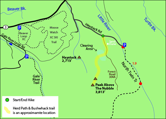
| Peak Above the Nubble Trail Maps - Directions from the parking lot to the summit |
Top |
The map below shows how to get to the summit of Peak Above the Nubble.
From the start of old forest road 304A (only marked by 3 large boulders, blocking the road off from vehicles) off Haystack Road in Bethlehem, NH, start hiking down the old forest road. When you come to a sand dune hill on your left, bear right. A few more minutes up this road is the typical starting point of this bushwhack on the right side. (There was an arrow made out of sticks and a tiny cairn in October of 2014, but don't rely on this). This part of the hike is on a herd path for less than half a mile in young, but TALL, vegetation. It is very tight in this area, but the herd path is easy to follow if you keep your eyes on the ground. You will go through 2 small clearings, which is a nice break from the tall and thick vegetation you just came out of! Soon after you get out of the young vegetation, you are in open forest. It is not dense, so this part of the bushwhack is not that difficult, BUT a herd path is difficult to see.
Once you reach the summit of the Nubble (the smaller peak), there is obvious herd path that goes left and right. Go right and follow down and up hill to the summit of Peak Above the Nubble! The summit has a canister and summit sign. If you go down the herd path from the summit to the left, there is a great view (the only view on this summit) of North Twin Mountain.
To get back to the parking area, go back the same way you came up.
Click to download PDF Trail Map of Peak Above the Nubble
|
| |
|
| |
| Peak Above the Nubble View Photos |
Top |
|
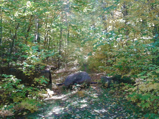
The start of this hike: Old forest road 304A off Haystack Road in Bethlehem, NH. Taken on 9/28/14. (It doesn't look like an obvious trail in this photo, but it is: This particular Fall day was covered in leaves!)
Old forest road 304A is an obvious trail to hike on. Taken on 9/28/14.
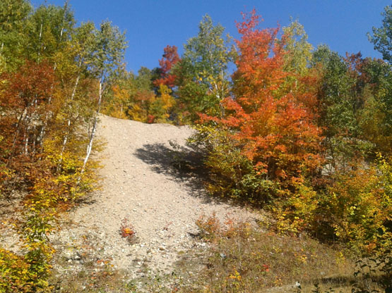
The sand dune you will see on you left on the old forest road. Bear right here. Taken on 9/28/14.
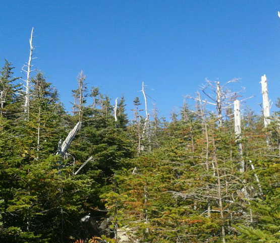
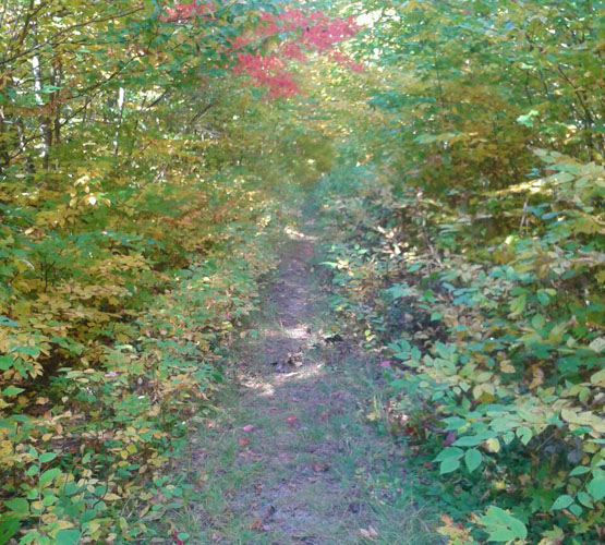
Taken near the summit of Peak Above the Nubble. Taken on 9/28/14.
|
| Peak Above the Nubble Driving Directions |
Top |
The parking area for the highlighted hike above is located on Haystack Road in Bethlehem, NH (so if you have a GPS, you can just enter that road and town, and drive roughly 1.7 miles on Haystack Road. You will see 3 large boulders blocking off old forest road 304A on the right side. This is the start of the hike. There is no actual parking lot, but this area can fit a couple cars.)
If you don't have a GPS and are coming from the South:
Take exit 35 off I-93 North to merge onto US-3 N, towards Twin Mountain / Lancaster. Drive on Route 3 for 7.9 miles until you come to Haystack Road on the right. Turn right and drive roughly 1.7 miles until you see 3 large boulders blocking off an old forest road on the right side. This is the start of the hike. There is no actual parking lot, but this area can fit a couple cars.
|
|
On this page: Information | Trail maps | View Photos | Driving Directions | Top
|
|
|
|
|
|
|
|
|
|
|
|
|
| |
| |
|
| New Hampshire 4,000 Footers |
Vermont + Maine 4,000 Footers |
Other Hiking Lists / Patches |
New England Mountain Ranges |
Stay Involved in New England |
New Hampshire
Mount Adams
Mount Bond
Bondcliff
Mount Bond, West Peak
Mount Cabot
Cannon Mountain
Mount Carrigain
Carter Dome
Carter, Middle
Carter, South
Mount Eisenhower
Mount Field
Mount Flume
Mount Galehead
Mount Garfield
Mount Hale
Mount Hancock
Mount Hancock, South Peak
Mount Isolation
Mount Jackson
Mount Jefferson
Mount Kinsman, North Peak
Mount Kinsman, South Peak
Mount Lafayette
Mount Liberty
Mount Lincoln
Mount Madison
Mount Monroe
Mount Moosilauke
Mount Moriah
Mount Osceola
Mount Osceola, East Peak
Owl's Head
Mount Passaconway
Mount Pierce
Mount Tecumseh
Mount Tom
Mount Tripyramid, Middle Peak
Mount Tripyramid, North Peak
Mount Twin, North Peak
Mount Twin, South Peak
Mount Washington
Mount Waumbek
Mount Whiteface
Mount Wildcat, A Peak
Mount Wildcat, D Peak
Mount Willey
Zealand Mountain |
Vermont
Mount Abraham
Camel's Hump
Mount Ellen
Killington Peak
Mount Mansfield
Maine
Mount Abraham
Mount Bigelow, Avery Peak
Mount Bigelow, West Peak
Crocker Mountain
Crocker Mountain, South
Mount Katahdin, Baxter Peak
Mount Katahdin, Hamlin Peak
North Brother Mountain
Old Speck Mountain
Mount Redington
Saddleback Mountain
Saddleback Mountain, The Horn
Spaulding Mountain
Sugarloaf Mountain |
NH 4,000 footers
NH 4,000 footers in Winter
New England 4,000 footers
NE 4,000 footers in Winter
NH Hundred Highest
New England Fifty Finest
52 With a view
Trailwrights 72 summit club
New England Hundred highest
NE Hundred highest in Winter
Northeast 111
48x12 "The Grid"
Red Lining
Belknap Range
LRCT / Castle in the Clouds
NH Fire Tower Quest
Hike by - Alphabetically
Hike by - Elevation
Hike by - Prominence
Hike by - Mountain Range |
Ranges in New Hampshire
View all NH mountain ranges
Baldface-Royce Range
Carter-Moriah Range
Dartmouth Range
Franconia Range
Kinsman Range
Mahoosuc
Range
Ossipee Mountains
Northern Ranges
Pemigewasset Wilderness
Pilot Range
Pliny Range
Presidential Range
Sandwich Range
Twin Range
Wapack Range
Western White Mountains
Willey Range
Ranges in Maine
View all ME mountain ranges
Baxter State Park
High Peaks
Bigelow Range
Eastern White Mountains
Ranges in Vermont
Green Mountains
Other VT mountain ranges |
NH Waterfalls
NH AMC Huts
Hiker's store |
New England 4,000 Footers | NH 4,000 Footers | VT 4,000 Footers | ME 4,000 Footers | Hiking Lists & Patches | Hiker's Store | Contact by email
© www.4000footers.com 2015. All rights reserved. We are not affiliated with the AMC or the AMC Four Thousand Footer Club |
|
|


