| New England 100 Highest List ↓ |
| Mount Abraham - Maine |
| Mount Abraham - Vermont |
| Mount Adams |
| Baldpate Mountain |
| Mount Bigelow, Avery Peak |
| Mount Bigelow, West Peak |
| Mount Bigelow, South Horn |
| Big Jay |
| Mount Bond |
| Bondcliff |
| Mount Bond, West Peak |
| Boundary Peak |
| Bread Loaf Mountain |
| Mount Cabot |
| Camel's Hump |
| Cannon Mountain |
| Cannon Ball, Northeast Peak |
| Mount Carrigain |
| Carter Dome |
| Carter, Middle |
| Carter, South |
| Mount Coe |
| Crocker Mountain |
| Crocker Mountain, South |
| Dorset Mountain |
| Mount Eisenhower |
| Elephant Mountain |
| Mount Ellen |
| Equinox Mountain |
| Mount Field |
| Mount Flume |
| Fort Mountain |
| Mount Galehead |
| Mount Garfield |
| Goose Eye Mountain |
| Mount Hale |
| Mount Hancock |
| Mount Hancock, South Peak |
| Mount Isolation |
| Mount Jackson |
| Jay Peak |
| Mount Jefferson |
| Mount Katahdin, Baxter Peak |
| Mount Katahdin, Hamlin Peak |
| Kennebago Divide |
| East Kennebago Mountain |
| Killington Peak |
| Mount Kinsman, North Peak |
| Mount Kinsman, South Peak |
| Mount Lafayette |
| Mount Liberty |
| Mount Lincoln |
| Mount Madison |
| Mount Mansfield |
| Mendon Peak |
| Mount Monroe |
| Mount Moosilauke |
| Mount Moriah |
| Mount Nancy |
| North Brother Mountain |
| Old Speck Mountain |
| Mount Osceola |
| Mount Osceola, East Peak |
| Owl's Head |
| Mount Passaconway |
| Peak Above the Nubble (PATN) |
| Pico Peak |
| Mount Pierce |
| Mount Redington |
| Saddleback Mountain |
| Saddleback Mountain, The Horn |
| Sandwich Mountain |
| Scar Ridge |
| Sleeper, East Peak |
| Snow Mountain - Franklin County |
| Snow Mountain - Oxford County |
| South Brother |
| Spauling Mountain |
| Stratton Mountain |
| Sugarloaf Mountain |
| Mount Tecumseh |
| The Bulge |
| The Horn |
| Mount Tom |
| Mount Tripyramid, Middle Peak |
| Mount Tripyramid, North Peak |
| Mount Twin, North Peak |
| Mount Twin, South Peak |
| Vose Spur |
| Mount Washington |
| Mount Waumbek |
| Mount Weeks |
| Mount Weeks, South |
| White Cap Mountain |
| Mount Whiteface |
| Mount Wildcat, A Peak |
| Mount Wildcat, D Peak |
| Mount Willey |
| Mount Wilson |
Zealand Mountain |
|
|
Hike / Bushwhack to Mendon Peak |
| |
| On this page: Information | Trail maps | View Photos | Driving Directions |
| |
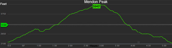
Elevation: 3,840 feet (1,170 meters)
Prominence:  280 feet (85 meters) 280 feet (85 meters)
Location: Killington / Mendon, Vermont (Rutland County)
Range: Green Mountains
Coordinates: 43°35'42" North 72°50'46" West
Rating: Difficult - This hike follows logging roads for roughly 3 miles but the last mile or so is a bushwhack, thus the difficulty rating. The first 3 miles is all flat and low inclines, but there are several river crossings that can be tricky in high water.
Features: Logging roads, Bushwhack, summit sign & canister, river crossings
Distance of highlighted hike below: Roughly 7.75 miles (depends on your bushwhack route).
|
 |
Mendon Peak is a 3,840 foot mountain located in Killington and Mendon, Vermont in Rutland County in the famous Green Mountains. The peak sits in the Calvin Coolidge State Forest. It is flanked to the East by Little Killington Mountain and to the South by Robinson Hill.
There is no trail to the summit of Mendon Peak. The most common routes to reach the summit is by hiking along old logging roads then bushwhacking for about a mile to the peak, which is on the New England Hundred highest hiking list.
|
| Mendon Peak Trail Maps - Directions from the parking lot to the summit |
Top |
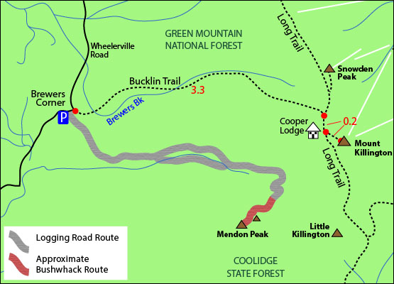
The map below shows a suggested route to the summit of Mendon Peak via old logging roads and a bushwhack. There are several ways to reach the summit, but these directions will show a loop hike, which requires several river crossings. (There are a lot of forks and turns in this route, and it took me, personally, 2 attempts to locate the summit based off of other website's directions, so I have tried my best to be as descriptive as possible, so you don't end up going in circles like i did on the many twists and turns on these logging roads :)
(NOTE: THIS IS A BUSHWHACK HIKE. THERE IS NO MAINTAINED TRAIL TO THE SUMMIT OF MENDON PEAK, SO ONLY ATTEMPT THIS IF YOU ARE SMART WITH A NAVIGATION SYSTEM AND/OR KNOW WHAT YOU ARE DOING.)
NOTE: The map below shows only the logging roads used to reach Mendon Peak for this hike. There are many other logging roads, that are NOT drawn into this map. As you will see below in in the instructions, there are many many turns.
If you are looking at the Bucklin Traillhead on Wheelerville Road in Mendon / Killington, Vermont, there is a black gate located just to the right; this is the start of the hike to Mendon Peak.
Hike on the old logging road past the gate for roughly 1 mile where you will find yourself at a fork. (You will pass a house on your left at the [roughly] 0.65 mile mark). At this fork go left. In roughly 0.25 miles, fork left again. Then shortly after (roughly 0.10 miles) fork right. You will fork right again in roughly 0.70 miles. In roughly 0.20 miles go left, then shortly after (roughly 0.10 miles) go right. In roughly 0.10 miles you will cross a river. Shortly after (roughly 0.10 miles) you will fork right. You will cross the river again at roughly 0.30 miles. You will see a cairn in roughly 0.25 miles, and the main logging road you are on turns left. In roughly 0.20 miles, there is another cairn that marks the beginning of the bushwhack. Turn right into the woods to begin your bushwhack. There is a herd path the entire way up, but you may lose it, and pick it back up again on and off. The herd path closer to the summit is obvious.
NOTE: If it is a cloudy day and you have no views, when close to the summit, there is an area that looks like a high point on the mountain that has herd path going left and right. To get to the SW peak, which is the higher of the 2 peaks that make up Mendon, go right to find the summit with sign and canister.
Click to download PDF Trail Map of Mendon Peak
|
| |
|
| |
 |
| |
| |
| Mendon Peak View Photos |
Top |
|
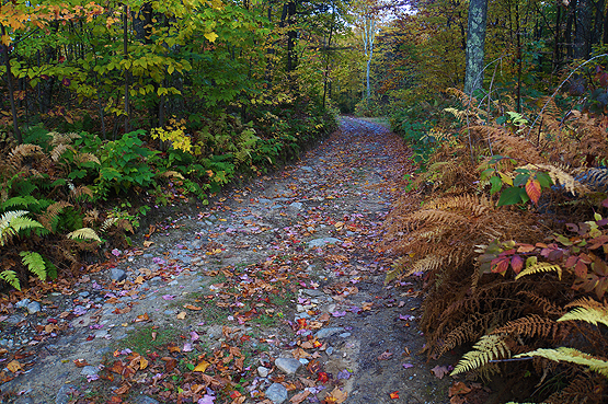
The old logging road that begins your hike. Taken on October 12, 2014.
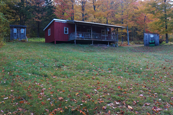
The cottage you will see roughly 0.65 into the hike. Taken on October 12, 2014.
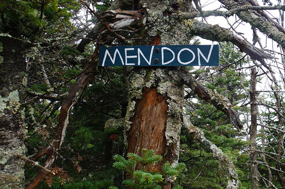
Summit sign on Mendon Peak. Taken on October 26, 2014.
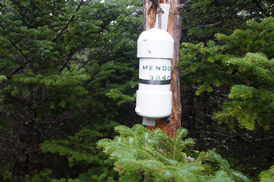
Summit canister on Mendon Peak. Taken on October 26, 2014.
|
| Mendon Peak Driving Directions |
Top |
If you have a GPS, the traillhead is on Wheelerville Road in Killington (or Mendon), Vermont. (If you enter 20 Wheelerville Road, it should take you close to the traillhead parking lot).
From the South, get onto I-89 North. Take exit 1 for US 4 / Woodstock Road towards Rutland / Quechee. Turn left onto Route 4. Drive 10.4 miles on Route 4 West and turn slight left to stay on Route 4 West. Drive 25.9 miles on Route 4 West, and turn left onto Wheelerville Road. Drive roughly 4 miles to the Bucklin Traillhead parking area. The hike to Mendon Peak starts after the black gate to the right of the parking area.
|
|
On this page: Information | Trail maps | View Photos | Driving Directions | Top
|
|
|
|
|
|
|
|
|
|
|
|
|
| |
| |
|
| New Hampshire 4,000 Footers |
Vermont + Maine 4,000 Footers |
Other Hiking Lists / Patches |
New England Mountain Ranges |
Stay Involved in New England |
New Hampshire
Mount Adams
Mount Bond
Bondcliff
Mount Bond, West Peak
Mount Cabot
Cannon Mountain
Mount Carrigain
Carter Dome
Carter, Middle
Carter, South
Mount Eisenhower
Mount Field
Mount Flume
Mount Galehead
Mount Garfield
Mount Hale
Mount Hancock
Mount Hancock, South Peak
Mount Isolation
Mount Jackson
Mount Jefferson
Mount Kinsman, North Peak
Mount Kinsman, South Peak
Mount Lafayette
Mount Liberty
Mount Lincoln
Mount Madison
Mount Monroe
Mount Moosilauke
Mount Moriah
Mount Osceola
Mount Osceola, East Peak
Owl's Head
Mount Passaconway
Mount Pierce
Mount Tecumseh
Mount Tom
Mount Tripyramid, Middle Peak
Mount Tripyramid, North Peak
Mount Twin, North Peak
Mount Twin, South Peak
Mount Washington
Mount Waumbek
Mount Whiteface
Mount Wildcat, A Peak
Mount Wildcat, D Peak
Mount Willey
Zealand Mountain |
Vermont
Mount Abraham
Camel's Hump
Mount Ellen
Killington Peak
Mount Mansfield
Maine
Mount Abraham
Mount Bigelow, Avery Peak
Mount Bigelow, West Peak
Crocker Mountain
Crocker Mountain, South
Mount Katahdin, Baxter Peak
Mount Katahdin, Hamlin Peak
North Brother Mountain
Old Speck Mountain
Mount Redington
Saddleback Mountain
Saddleback Mountain, The Horn
Spaulding Mountain
Sugarloaf Mountain |
NH 4,000 footers
NH 4,000 footers in Winter
New England 4,000 footers
NE 4,000 footers in Winter
NH Hundred Highest
New England Fifty Finest
52 With a view
Trailwrights 72 summit club
New England Hundred highest
NE Hundred highest in Winter
Northeast 111
48x12 "The Grid"
Red Lining
Belknap Range
LRCT / Castle in the Clouds
NH Fire Tower Quest
Hike by - Alphabetically
Hike by - Elevation
Hike by - Prominence
Hike by - Mountain Range |
Ranges in New Hampshire
View all NH mountain ranges
Baldface-Royce Range
Carter-Moriah Range
Dartmouth Range
Franconia Range
Kinsman Range
Mahoosuc
Range
Ossipee Mountains
Northern Ranges
Pemigewasset Wilderness
Pilot Range
Pliny Range
Presidential Range
Sandwich Range
Twin Range
Wapack Range
Western White Mountains
Willey Range
Ranges in Maine
View all ME mountain ranges
Baxter State Park
High Peaks
Bigelow Range
Eastern White Mountains
Ranges in Vermont
Green Mountains
Other VT mountain ranges |
NH Waterfalls
NH AMC Huts
Hiker's store |
New England 4,000 Footers | NH 4,000 Footers | VT 4,000 Footers | ME 4,000 Footers | Hiking Lists & Patches | Hiker's Store | Contact by email
© www.4000footers.com 2015. All rights reserved. We are not affiliated with the AMC or the AMC Four Thousand Footer Club |
|
s
|


