| New England 100 Highest List ↓ |
| Mount Abraham - Maine |
| Mount Abraham - Vermont |
| Mount Adams |
| Baldpate Mountain |
| Mount Bigelow, Avery Peak |
| Mount Bigelow, West Peak |
| Mount Bigelow, South Horn |
| Big Jay |
| Mount Bond |
| Bondcliff |
| Mount Bond, West Peak |
| Boundary Peak |
| Bread Loaf Mountain |
| Mount Cabot |
| Camel's Hump |
| Cannon Mountain |
| Cannon Ball, Northeast Peak |
| Mount Carrigain |
| Carter Dome |
| Carter, Middle |
| Carter, South |
| Mount Coe |
| Crocker Mountain |
| Crocker Mountain, South |
| Dorset Mountain |
| Mount Eisenhower |
| Elephant Mountain |
| Mount Ellen |
| Equinox Mountain |
| Mount Field |
| Mount Flume |
| Fort Mountain |
| Mount Galehead |
| Mount Garfield |
| Goose Eye Mountain |
| Mount Hale |
| Mount Hancock |
| Mount Hancock, South Peak |
| Mount Isolation |
| Mount Jackson |
| Jay Peak |
| Mount Jefferson |
| Mount Katahdin, Baxter Peak |
| Mount Katahdin, Hamlin Peak |
| Kennebago Divide |
| East Kennebago Mountain |
| Killington Peak |
| Mount Kinsman, North Peak |
| Mount Kinsman, South Peak |
| Mount Lafayette |
| Mount Liberty |
| Mount Lincoln |
| Mount Madison |
| Mount Mansfield |
| Mendon Peak |
| Mount Monroe |
| Mount Moosilauke |
| Mount Moriah |
| Mount Nancy |
| North Brother Mountain |
| Old Speck Mountain |
| Mount Osceola |
| Mount Osceola, East Peak |
| Owl's Head |
| Mount Passaconway |
| Peak Above the Nubble (PATN) |
| Pico Peak |
| Mount Pierce |
| Mount Redington |
| Saddleback Mountain |
| Saddleback Mountain, The Horn |
| Sandwich Mountain |
| Scar Ridge |
| Sleeper, East Peak |
| Snow Mountain - Franklin County |
| Snow Mountain - Oxford County |
| South Brother |
| Spauling Mountain |
| Stratton Mountain |
| Sugarloaf Mountain |
| Mount Tecumseh |
| The Bulge |
| The Horn |
| Mount Tom |
| Mount Tripyramid, Middle Peak |
| Mount Tripyramid, North Peak |
| Mount Twin, North Peak |
| Mount Twin, South Peak |
| Vose Spur |
| Mount Washington |
| Mount Waumbek |
| Mount Weeks |
| Mount Weeks, South |
| White Cap Mountain |
| Mount Whiteface |
| Mount Wildcat, A Peak |
| Mount Wildcat, D Peak |
| Mount Willey |
| Mount Wilson |
Zealand Mountain |
|
|
Hike Mount Nancy |
| |
| On this page: Information | Trail maps | View Photos | Driving Directions |
| |
Elevation: 3,926 feet (1,197 meters)
Prominence:  1,006 feet (307 meters) 1,006 feet (307 meters)
Location: Lincoln, New Hampshire (Grafton County)
Range: Nancy Range in the Pemigewasset Wilderness
Coordinates: 44°07'21" North 71°24'17" West
Rating: Difficult - The Nancy Pond Trail is a nice low incline hike up to Nancy Cascades. After the cascades the hike is steep and strenuous for a bit before leveling out near Nancy and Norcross ponds. The herd path up to Mount Nancy is very steep in most areas but also easy to navigate.
Features: Herd path, summit views, Nancy Pond, Norcross Pond, Nancy Cascades.
Distance of highlighted hike below: Roughly 10 miles
|
 |
Mount Nancy, formally known as Mount Amorisgelu, is a 3,862 foot mountain in the Pemigewasset Wilderness of the White Mountains in New Hampshire. It is the highest point in the Nancy Range. It is flanked to the Northeast by Mount Bemis, to the Southwest by Mount Anderson and to the Southeast by Duck Pond Mountain.
Currently there is no maintained trail to the summit of Mount Nancy, but there used to be, so the herd path up to the summit that begins at the end of Norcross Pond, is easy to follow. Nancy is on the New England Hundred highest hiking list as well as the New Hampshire Hundred highest hiking list.
|
| Mount Nancy Trail Maps - Directions from the parking lot to the summit |
Top |
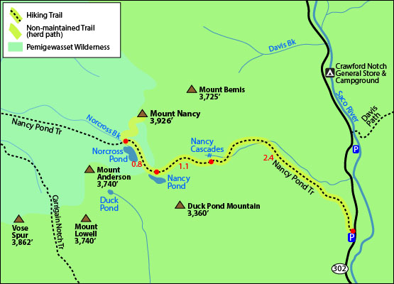
The map below shows how to get to the summit of Mount Nancy.
From the Nancy Pond traillhead off Route 302, hike up the Nancy Pond Trail for 2.4 miles until you reach the Nancy Cascades. From the parking lot to this area is roughly 1,500 feet elevation gain. From the cascades continue along the Nancy Pond Trail for 1.1 miles where you will reach Nancy Pond. That 1.1 mile stretch is pretty rough and steep. After the pond, continue on the Nancy Pond Trail for 0.8 miles until you come to the end of Norcross Pond. You will find yourself in a flat open area where the Nancy Pond Trail continues straight. Instead of going straight, the old trail that used to go up to Mount Nancy is on your hard right. Less than a minute into that old trail, you will see a fork. Take the fork left all the way to the summit of Nancy. For an unmaintained trail, it is easy to follow, with very little areas of thick brush. (also depends on the season). The trail is very steep and strenuous in areas but the views at the summit are worth it! You can see Mount Washington in the distance. The summit has a summit sign.
To get back to the parking area, go back the same way you came up.
Click to download PDF Trail Map of Mount Nancy
|
| |
|
| |
| Mount Nancy View Photos |
Top |
|
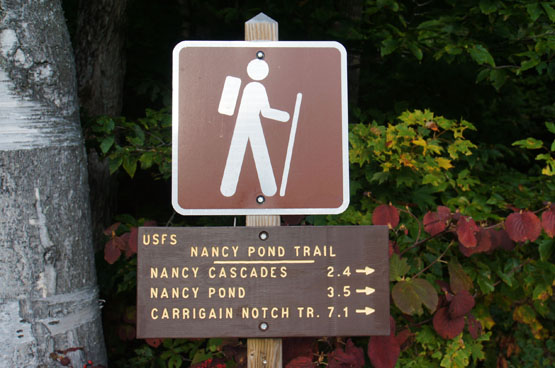
Traillhead for Mount Nancy. Nancy Pond Trail. Taken on 9/25/14.
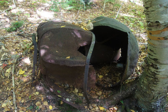
Some old remains along the Nancy Pond Trail. Taken on 9/25/14.
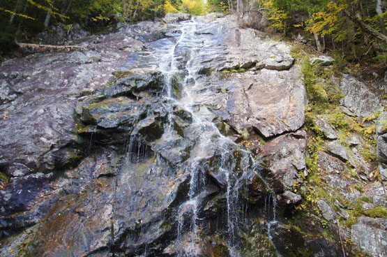
Nancy Cascades along the Nancy Pond Trail in Fall (This waterfall looks alot better in Spring!)
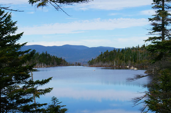
Norcross Pond along the Nancy Pond Trail. Taken on 9/25/14.
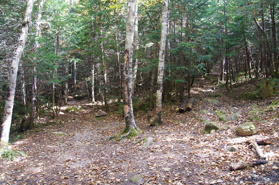
The unmaintained trail up to Mount Nancy (go left at this fork). Taken on 9/25/14.
The steep, strenuous part of the unmaintained trail up to Mount Nancy. Taken on 9/25/14.
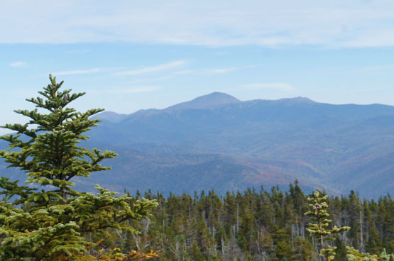
Views from the summit of Mount Nancy. Taken on 9/25/14.
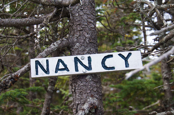
Summit sign for Mount Nancy! Taken on 9/25/14.
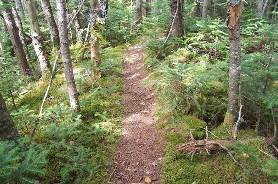
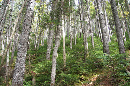
The unmaintained trail looked like this most of the way up to Mount Nancy; easy to navigate, with some areas of thick vegetation (but never too bad). Taken on 9/25/14.
|
| Mount Nancy Driving Directions |
Top |
The parking lot for the highlighted hike above is located on Route 302. From the South, take exit 35 off I-93 North to merge onto US-3-N toward Twin Mountain / Lancaster. Drive about 10 miles and turn right onto US Route 302 East. Drive roughly 18 miles until you come to the Nancy Pond Traillhead parking area on the right side. (Just past the Notchland Inn and the Davis Path Traillhead. If you reach Sawyer River Road or the Fourth Iron Tent site, you have driven too far.)
|
|
On this page: Information | Trail maps | View Photos | Driving Directions | Top
|
|
|
|
|
|
|
|
|
|
|
|
|
| |
| |
|
| New Hampshire 4,000 Footers |
Vermont + Maine 4,000 Footers |
Other Hiking Lists / Patches |
New England Mountain Ranges |
Stay Involved in New England |
New Hampshire
Mount Adams
Mount Bond
Bondcliff
Mount Bond, West Peak
Mount Cabot
Cannon Mountain
Mount Carrigain
Carter Dome
Carter, Middle
Carter, South
Mount Eisenhower
Mount Field
Mount Flume
Mount Galehead
Mount Garfield
Mount Hale
Mount Hancock
Mount Hancock, South Peak
Mount Isolation
Mount Jackson
Mount Jefferson
Mount Kinsman, North Peak
Mount Kinsman, South Peak
Mount Lafayette
Mount Liberty
Mount Lincoln
Mount Madison
Mount Monroe
Mount Moosilauke
Mount Moriah
Mount Osceola
Mount Osceola, East Peak
Owl's Head
Mount Passaconway
Mount Pierce
Mount Tecumseh
Mount Tom
Mount Tripyramid, Middle Peak
Mount Tripyramid, North Peak
Mount Twin, North Peak
Mount Twin, South Peak
Mount Washington
Mount Waumbek
Mount Whiteface
Mount Wildcat, A Peak
Mount Wildcat, D Peak
Mount Willey
Zealand Mountain |
Vermont
Mount Abraham
Camel's Hump
Mount Ellen
Killington Peak
Mount Mansfield
Maine
Mount Abraham
Mount Bigelow, Avery Peak
Mount Bigelow, West Peak
Crocker Mountain
Crocker Mountain, South
Mount Katahdin, Baxter Peak
Mount Katahdin, Hamlin Peak
North Brother Mountain
Old Speck Mountain
Mount Redington
Saddleback Mountain
Saddleback Mountain, The Horn
Spaulding Mountain
Sugarloaf Mountain |
NH 4,000 footers
NH 4,000 footers in Winter
New England 4,000 footers
NE 4,000 footers in Winter
NH Hundred Highest
New England Fifty Finest
52 With a view
Trailwrights 72 summit club
New England Hundred highest
NE Hundred highest in Winter
Northeast 111
48x12 "The Grid"
Red Lining
Belknap Range
LRCT / Castle in the Clouds
NH Fire Tower Quest
Hike by - Alphabetically
Hike by - Elevation
Hike by - Prominence
Hike by - Mountain Range |
Ranges in New Hampshire
View all NH mountain ranges
Baldface-Royce Range
Carter-Moriah Range
Dartmouth Range
Franconia Range
Kinsman Range
Mahoosuc
Range
Ossipee Mountains
Northern Ranges
Pemigewasset Wilderness
Pilot Range
Pliny Range
Presidential Range
Sandwich Range
Twin Range
Wapack Range
Western White Mountains
Willey Range
Ranges in Maine
View all ME mountain ranges
Baxter State Park
High Peaks
Bigelow Range
Eastern White Mountains
Ranges in Vermont
Green Mountains
Other VT mountain ranges |
NH Waterfalls
NH AMC Huts
Hiker's store |
New England 4,000 Footers | NH 4,000 Footers | VT 4,000 Footers | ME 4,000 Footers | Hiking Lists & Patches | Hiker's Store | Contact by email
© www.4000footers.com 2015. All rights reserved. We are not affiliated with the AMC or the AMC Four Thousand Footer Club |
|
|


